

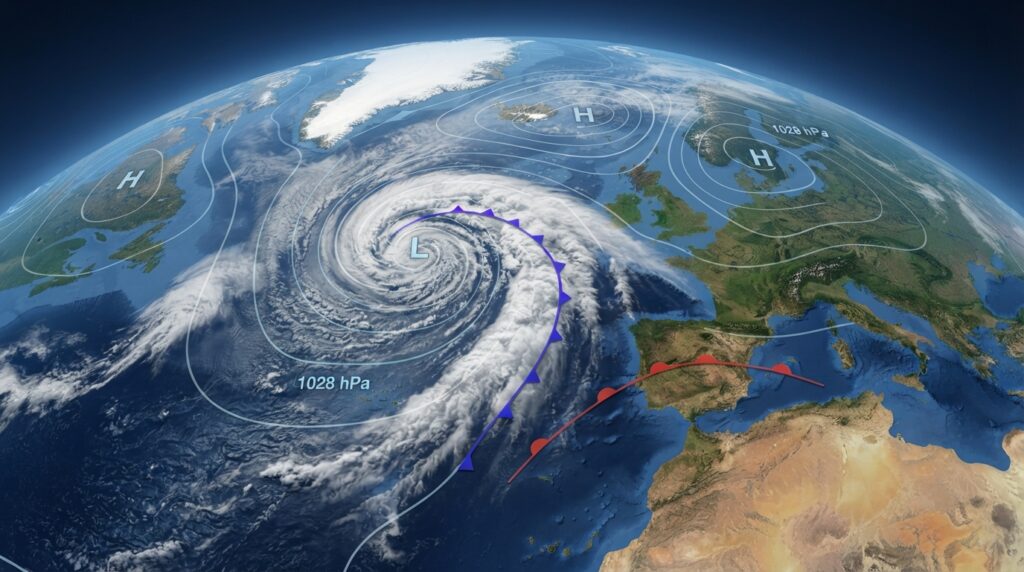
Synoptic meteorology is the branch of atmospheric science that studies large-scale weather systems—such as high and low-pressure systems, fronts, and cyclones—across broad geographic regions and time scales. Meteorologists use synoptic charts, radiosonde data, and numerical weather models to analyze and forecast weather patterns that span hundreds to thousands of kilometers.
Few scientific disciplines affect daily life as directly and consistently as meteorology. From the morning commute to agricultural planning, aviation routing to emergency disaster response, weather forecasts shape decisions at every level of human activity. At the heart of modern weather forecasting sits a foundational discipline: synoptic meteorology—the systematic study of atmospheric conditions across large spatial and temporal scales.
Understanding synoptic meteorology is not simply an academic exercise. It provides the conceptual framework through which meteorologists interpret the atmosphere as an interconnected system, rather than a collection of isolated weather events. This article explores what synoptic meteorology is, how it works, what tools it relies on, and why it remains indispensable to modern science and society.
The Definition and Scope of Synoptic Meteorology
The term “synoptic” derives from the Greek synoptikos, meaning “seen together” or “affording a general view.” In atmospheric science, the word captures the discipline’s defining ambition: to observe and analyze weather conditions simultaneously across large geographic areas, creating a coherent snapshot of the atmosphere at any given moment.
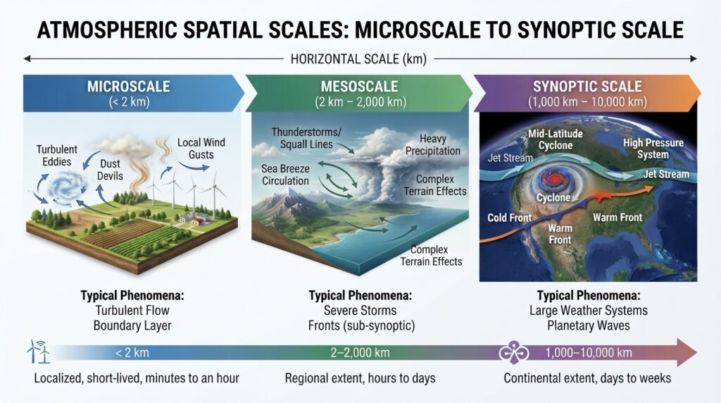
Synoptic meteorology operates at a specific spatial scale—generally between 1,000 and 10,000 kilometers. This distinguishes it from microscale meteorology, which examines localized phenomena
like turbulence or dust devils, and from mesoscale meteorology, which covers intermediate features such as thunderstorms and sea breezes. Synoptic-scale processes, by contrast, include the large pressure systems, frontal boundaries, jet streams, and extratropical cyclones that drive regional and continental weather patterns over hours to days.
The temporal scale of synoptic meteorology also sets it apart. Synoptic analyses typically cover periods ranging from several hours to a few days—the time frame most relevant to short- and medium-range weather forecasting. It is within this window that the discipline delivers its greatest practical value.
The Historical Development of Synoptic Analysis
Synoptic meteorology as a formal discipline emerged in the mid-nineteenth century, enabled by a technological breakthrough: the telegraph. Before real-time data transmission was possible, weather observations at distant stations arrived too slowly to be compiled into a coherent picture of current atmospheric conditions. The telegraph changed this entirely.
In 1854, the British Meteorological Office, under the direction of Vice-Admiral Robert FitzRoy, began collecting simultaneous weather reports from stations across the United Kingdom and compiling them into what became the first synoptic weather charts. FitzRoy’s maps allowed meteorologists to see, for the first time, how weather systems moved across the country as cohesive structures.

The discipline advanced significantly in the early twentieth century through the work of the Bergen School of Meteorology in Norway. Led by Vilhelm Bjerknes and his colleagues—including his son Jacob Bjerknes—the school developed the Norwegian Cyclone Model, a landmark framework describing how extratropical cyclones form, mature, and decay along frontal boundaries. This model introduced the concepts of warm fronts and cold fronts that remain standard in meteorological analysis today.
Subsequent decades brought further development through numerical weather prediction, satellite imagery, and global data assimilation systems, transforming synoptic meteorology from a largely observational science into a highly computational one.
Core Concepts in Synoptic Meteorology
Pressure Systems and Atmospheric Circulation
At the foundation of synoptic analysis lie atmospheric pressure systems. A high-pressure system, or anticyclone, is characterized by descending air, relatively calm conditions, and clear skies. A low-pressure system, or cyclone, features rising air, convergence at the surface, and is typically associated with cloud formation, precipitation, and unsettled weather.
These systems do not exist in isolation. They form part of a broader pattern of atmospheric circulation driven by differential solar heating, the Coriolis effect, and surface topography. The arrangement and movement of pressure systems across a synoptic chart reveal the likely trajectory of weather across a region.
Frontal Systems
Fronts are boundaries between air masses of differing temperature and humidity. A cold front marks the leading edge of a cooler, denser air mass advancing into a warmer region. As the cold air undercuts the warmer air, rapid uplift occurs, often producing intense convective activity, heavy precipitation, and a sharp temperature drop following the front’s passage.
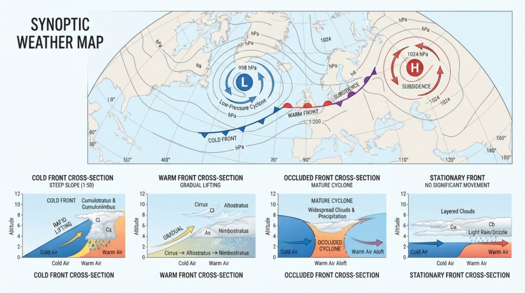
A warm front, by contrast, represents the advance of warmer air over a retreating cooler air mass. The uplift along a warm front is more gradual, producing widespread stratiform clouds and steady precipitation ahead of the boundary. Occluded fronts and stationary fronts represent additional configurations that emerge as cyclones mature.
Frontal analysis is among the most critical components of synoptic meteorology, as fronts are directly responsible for many of the significant weather events experienced across mid-latitude regions.
Jet Streams and Upper-Level Dynamics
Synoptic meteorology does not confine itself to surface observations. Upper-level atmospheric dynamics—particularly jet streams—play a decisive role in shaping surface weather patterns.
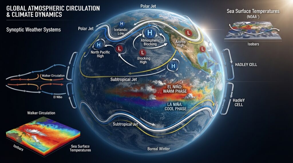
Jet streams are narrow bands of fast-moving air in the upper troposphere, typically flowing west to east at speeds exceeding 160 kilometers per hour. The polar jet stream, which migrates northward in summer and southward in winter, exerts powerful influence over the tracks of extratropical cyclones. Where the jet stream dips southward in a trough, surface low-pressure systems tend to develop and deepen. Where it bulges northward in a ridge, high-pressure dominates.
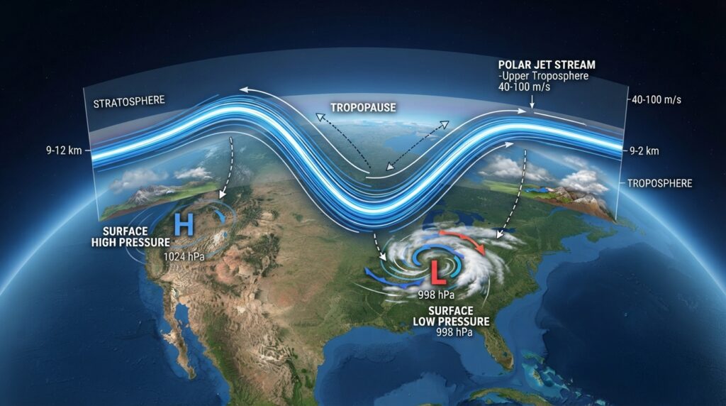
Understanding the relationship between upper-level flow and surface weather is central to synoptic analysis and forms the basis for most medium-range weather forecasting.
The Tools and Methods of Synoptic Meteorology
Synoptic Charts and Surface Analysis Maps
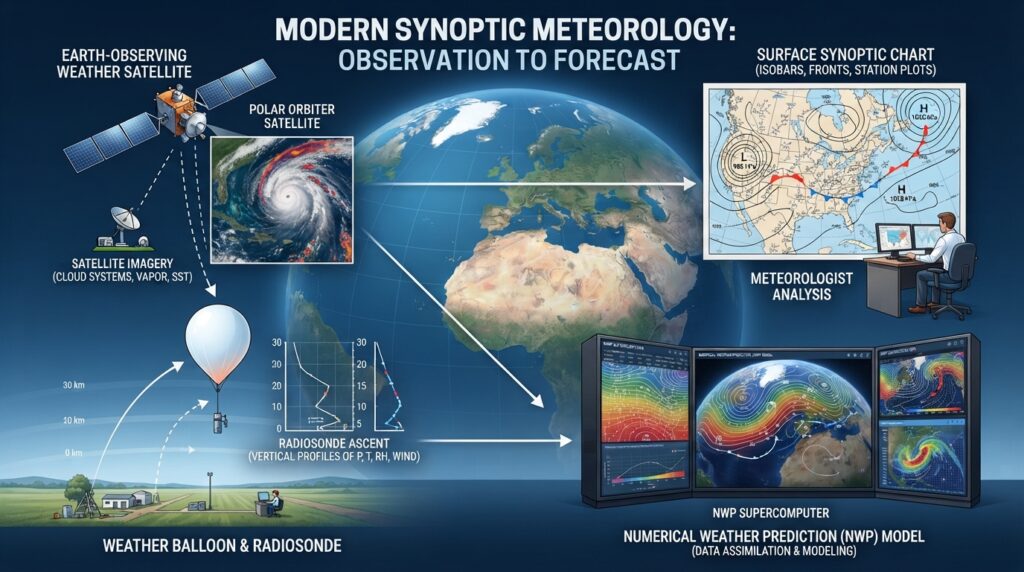
The synoptic chart—also called a weather map or surface analysis map—is the primary visual tool of the discipline. These charts display isobars (lines of equal pressure), frontal boundaries, wind observations, temperature, and other meteorological variables across a broad geographic area at a specific time.
Meteorologists use synoptic charts to identify and track pressure systems, frontal zones, and areas of significant weather. Modern charts are generated using data assimilated from thousands of surface weather stations, buoys, ships, and automated sensors distributed globally.
Upper-Air Observations and Radiosonde Data
Surface observations alone provide an incomplete picture of atmospheric behavior. To analyze the three-dimensional structure of the atmosphere, meteorologists rely heavily on upper-air data collected by radiosondes—instrument packages attached to weather balloons that measure temperature, humidity, pressure, and wind speed as they ascend through the atmosphere.
Radiosonde launches occur at approximately 900 stations worldwide, twice daily, at 00:00 and 12:00 Coordinated Universal Time (UTC). The data are fed into global weather models and plotted on upper-air charts such as 500 hPa and 250 hPa maps, which meteorologists analyze alongside surface charts to build a coherent understanding of the atmospheric column.
Numerical Weather Prediction Models
Numerical weather prediction (NWP) models are now the primary computational tool used to extend synoptic analysis into the future. These models divide the atmosphere into a three-dimensional grid and apply the fundamental equations of fluid dynamics and thermodynamics to simulate how atmospheric conditions will evolve over time.
Major NWP systems include the European Centre for Medium-Range Weather Forecasts (ECMWF) Integrated Forecast System, the National Oceanic and Atmospheric Administration (NOAA) Global Forecast System (GFS), and the UK Met Office Unified Model. These models ingest enormous volumes of observational data through a process called data assimilation, producing forecasts that extend from hours to approximately two weeks into the future.
Synoptic meteorologists interpret model output in conjunction with observational data, applying their understanding of physical processes to assess forecast confidence and identify potential model errors.
Satellite Imagery
Satellite imagery has transformed synoptic meteorology since its introduction in the 1960s. Geostationary satellites, positioned approximately 35,800 kilometers above the equator, provide continuous imagery of cloud patterns, water vapor distribution, and surface temperatures. Polar-orbiting satellites offer finer spatial resolution across different times of day.
Water vapor imagery, in particular, has proven invaluable for synoptic analysis. It reveals the structure of upper-level troughs and ridges, moisture transport pathways, and areas of atmospheric divergence and convergence—all of which are critical to understanding and forecasting synoptic-scale weather.
The Role of Synoptic Meteorology in Weather Forecasting
Weather forecasting as practiced by national meteorological agencies rests on synoptic meteorology as its conceptual backbone. A skilled forecaster approaching any forecast situation begins by examining current synoptic conditions—the positions of pressure systems, fronts, and upper-level features—before considering smaller-scale processes.
The synoptic situation defines the “weather regime” under which a region is operating. This regime determines whether conditions favor storm development, precipitation, dry and settled weather, or transitional states between these patterns. Even localized forecasts for specific cities or regions are largely conditioned by the synoptic environment in which they occur.
This makes synoptic competency fundamental not only to general public weather forecasts but also to specialized applications including aviation meteorology, marine weather services, agricultural forecasting, and severe weather prediction.
Synoptic Meteorology and Climate Research
Beyond day-to-day forecasting, synoptic meteorology contributes meaningfully to climate science. The study of synoptic climatology—the analysis of how synoptic patterns recur over time and vary across seasons and years—provides insight into regional climate variability and the influence of large-scale circulation modes.
Phenomena such as the North Atlantic Oscillation (NAO), the El Niño–Southern Oscillation (ENSO), and the Arctic Oscillation are defined by their impact on synoptic-scale circulation patterns. Understanding how these oscillations shift the frequency, intensity, and location of synoptic systems helps researchers attribute past climate variability and project future changes.
As climate change alters the thermal gradient between the equator and poles, researchers are actively examining whether synoptic-scale features—particularly jet streams and blocking patterns—are responding in measurable ways. These questions sit at the intersection of synoptic meteorology and climate dynamics, representing one of the most active frontiers in atmospheric science.
The Enduring Relevance of Synoptic Meteorology
The development of sophisticated numerical models and automated observing systems has not diminished the importance of synoptic meteorology. Rather, it has elevated the role of the human forecaster who must interpret model output through the lens of physical understanding, recognize when models diverge from reality, and communicate nuanced uncertainty to decision-makers and the public.
Synoptic meteorology provides exactly this foundation. Its principles explain why pressure systems behave as they do, how fronts develop and decay, and why the upper-level atmosphere steers surface weather in predictable ways. These are not abstract concepts—they are the rules by which the atmosphere operates.
Students of atmospheric science begin with synoptic meteorology for good reason. It builds the observational intuition and physical reasoning that no algorithm, however powerful, can fully replace. As weather forecasting continues to evolve with advances in artificial intelligence and ensemble modeling, practitioners grounded in synoptic principles will remain best equipped to apply these tools with precision and judgment.
Synoptic meteorology began with hand-drawn charts compiled by telegraph. Today it encompasses petabytes of satellite data, global modeling systems, and real-time observational networks spanning every continent and ocean. The tools have changed dramatically. The fundamental purpose—to see the atmosphere whole, and to understand what it will do next—has not.