

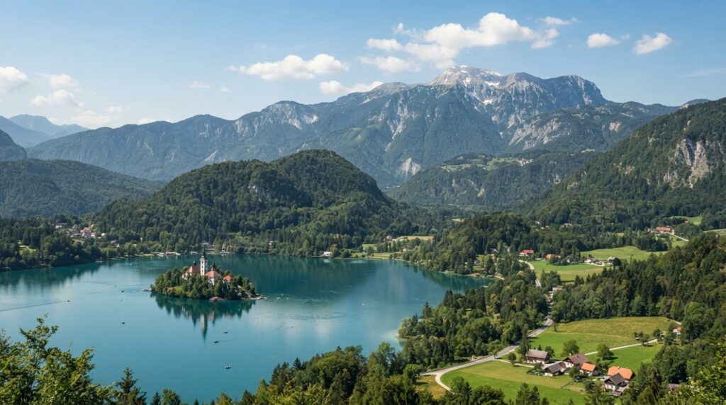
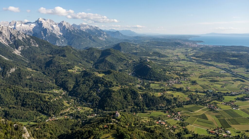
Slovenia occupies a small but geographically layered stretch of Central Europe, wedged between the eastern Alps and the northern Adriatic Sea. Few countries of its size pack in such a range of physical environments: snow-capped peaks give way to limestone plateaus within a short drive, and those plateaus descend into river valleys before flattening into the edge of the Pannonian plain. This convergence of landscapes is not incidental. Slovenia sits at the exact point where several of Europe’s major physical regions — the Alps, the Dinaric Alps, the Pannonian Basin, and the Mediterranean climatic zone — meet and overlap. Understanding Slovenia’s geography means understanding how these systems interact, and how they have shaped where people live, how they farm, what they build, and how the country connects to its neighbors.
Geographic Location and Regional Context
Slovenia is a land-connected Central European country with a short Adriatic coastline, bordered by Austria to the north, Hungary to the northeast, Croatia to the south and southeast, and Italy to the west. Its total area is modest — roughly 20,273 square kilometers, making it one of the smaller states in Europe — yet its location places it at a genuine crossroads. To the northwest, the Julian Alps and Karawanks connect Slovenia to the broader Alpine arc shared with Austria and Italy. To the south and southeast, the Dinaric Alps extend the country’s terrain into the limestone country associated with the western Balkans. To the northeast, the land flattens into the edge of the Pannonian Basin, a lowland system that stretches across Hungary and beyond. And along its short Adriatic edge, Slovenia touches the Mediterranean climatic and cultural world.
This convergence is why Slovenia resists easy regional labeling. It is not accurate to describe Slovenia simply as a Balkan country; while it shares some historical and geological connections with the western Balkans through the Dinaric system, its climate, settlement patterns, and cultural development are more closely tied to the Alpine and Central European sphere. At the same time, describing Slovenia as purely Alpine ignores its karst plateaus, its Pannonian lowlands, and its Adriatic access. The most accurate description situates Slovenia within Central Europe, with strong Alpine, northern Adriatic, and transitional southeastern European characteristics.
It is also worth distinguishing the modern Republic of Slovenia from the historical territories that once covered similar ground. The lands that make up Slovenia today were part of the Habsburg Monarchy for centuries, later the Austro-Hungarian Empire, and then a constituent republic of Yugoslavia. None of these historical entities shared Slovenia’s current borders, and treating them as interchangeable with the modern state obscures how recent Slovenia’s present political geography actually is.
Key Facts
|
Category |
Detail |
|---|---|
|
Official name |
Republic of Slovenia |
|
Capital |
Ljubljana |
|
Region |
Central Europe |
|
Area |
approximately 20,273 km² |
|
Population |
approximately 2.1 million (2023, Statistical Office of the Republic of Slovenia) |
|
Highest point |
Triglav, 2,864 m, Julian Alps |
|
Major mountain systems |
Julian Alps, Kamnik–Savinja Alps, Karawanks, Dinaric Alps |
|
Major rivers |
Sava, Drava, Mura, Soča, Savinja, Krka, Kolpa |
|
Major lakes |
Lake Bled, Lake Bohinj, Cerknica Lake |
|
Coastline |
approximately 46.6 km on the Adriatic Sea |
|
Climate |
Alpine, continental, and Mediterranean influences |
|
Currency |
Euro |
|
Administrative structure |
Municipalities and statistical regions under a national government |
|
Major national park |
Triglav National Park |
Physical Geography and Major Landforms
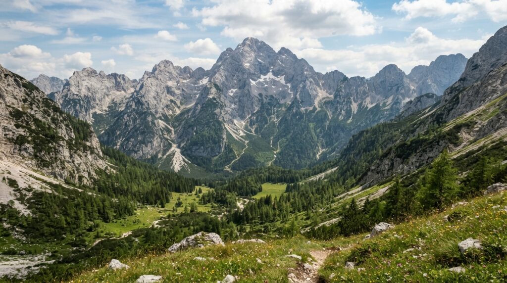
Slovenia’s physical geography changes dramatically across short distances. In the northwest, the Julian Alps and the Kamnik–Savinja Alps rise into jagged limestone peaks, glacial cirques, and steep valleys. The Karawanks form a narrower alpine ridge along the border with Austria. Moving south and east, the terrain transitions into the Dinaric Alps and the Slovenian Karst, a limestone plateau riddled with sinkholes, caves, and underground rivers. Between these highland systems lie lower basins — most notably the Ljubljana Basin, where the capital sits, and the Upper Sava Valley, which channels transportation and settlement through the Alpine north.
Further east and northeast, the landscape flattens considerably. The Drava and Mura lowlands mark Slovenia’s share of the Pannonian Basin, an area of gentler relief, fertile soils, and more continental farming patterns. The Vipava Valley, near the Italian border, forms a warm lowland corridor influenced by Mediterranean air moving inland from the Adriatic. Along the coast itself, the Slovenian littoral consists of low coastal hills and plateaus descending toward the sea.
Triglav, at 2,864 meters, is Slovenia’s highest peak and sits at the heart of the Julian Alps. Its significance extends beyond elevation: Triglav functions as a national symbol, and the mountain range surrounding it anchors the country’s largest protected natural area. The presence of a peak of this height, alongside extensive lowland and karst terrain, illustrates a broader point about Slovenia’s physical geography — the country is considerably more mountainous and topographically varied than its small area would suggest. More than half of Slovenia’s territory lies at elevations that support forest rather than farmland, a fact that shapes nearly every other aspect of the country’s human and economic geography.
Geological History and Tectonic Setting
Slovenia’s terrain is a direct product of its position at the junction of three major geological systems: the Alpine orogenic belt, the Dinaric fold-and-thrust system, and the sedimentary basin associated with the Pannonian region. Over tens of millions of years, the collision and compression of tectonic plates folded and faulted the rock layers beneath what is now Slovenia, producing the steep ridgelines of the Alps and the more complex, overlapping structures of the Dinarides.
Much of Slovenia’s bedrock consists of limestone and dolomite, laid down as marine sediment long before the mountains rose. These carbonate rocks are highly soluble, and where they dominate the surface — particularly across the Karst Plateau in the southwest — slightly acidic rainwater has slowly dissolved the stone over geological time. This process, known as karstification, has produced one of the most extensively studied karst landscapes in the world. Sinkholes, disappearing streams, underground rivers, and vast cave systems all trace back to this same chemical and structural process. Postojna Cave and the Škocjan Caves are the best-known results, both formed by rivers cutting through and dissolving limestone over long periods. The Škocjan Caves have been inscribed on the UNESCO World Heritage List, recognized for their exceptional karst features, including one of the largest known underground canyons.
More recent geological history includes the effects of Quaternary glaciation, which carved and reshaped many Alpine valleys, and ongoing river erosion, which continues to deepen valleys and transport sediment toward the lowlands. Tectonically, Slovenia remains active. The country sits near fault systems associated with the boundary between the Adriatic microplate and the Eurasian plate, and earthquake risk is a genuine consideration, particularly in the western and northwestern regions, where past seismic events have affected populated areas. Slovenia is not considered volcanically active; its geological hazards are tied to seismicity and karst instability rather than volcanism.
Mountains, Valleys, and Alpine Geography
The Julian Alps dominate Slovenia’s northwestern geography, forming a rugged limestone range shared with Italy. Triglav rises at their center, surrounded by high cirques, steep scree slopes, and alpine meadows that sit above the treeline for much of the year. To the east, the Kamnik–Savinja Alps present a similarly steep but slightly lower range, while the Karawanks stretch along the Austrian border, forming a natural boundary reinforced by geology rather than politics alone.
These mountains were significantly shaped by glaciation during past ice ages. Glacial erosion carved U-shaped valleys, deepened basins, and left behind moraines — ridges of debris marking the former extent of ice. Lake Bohinj, Slovenia’s largest natural lake, sits in one such glacially carved basin. The legacy of glaciation also shows up in the shape of Alpine valleys such as the Upper Sava Valley, which has long served as a natural transportation corridor connecting mountain communities and, more recently, international road and rail routes.
Three valleys deserve particular attention for their role in settlement and economic life: the Sava valley, which channels population, industry, and transport through north-central Slovenia; the Soča valley, known for its distinctive turquoise river and steep enclosing peaks; and the Savinja valley, an important agricultural and hop-growing corridor in the country’s north-central region. Each valley illustrates how Alpine terrain, rather than isolating communities, has historically directed where people settle and how they move — a contrast to the karst plateaus further south, where the absence of surface water and the presence of sinkholes made permanent settlement more difficult, and to the Pannonian lowlands, where flatter terrain and better soils supported denser agricultural settlement instead.
Rivers, Lakes, Drainage, and Water Geography
Slovenia’s rivers divide almost entirely between two drainage systems. Most of the country, including the Sava, Drava, Mura, Savinja, Krka, and Kolpa rivers, drains toward the Danube and ultimately the Black Sea. Only a small portion of western Slovenia, drained principally by the Soča River, flows toward the Adriatic Sea. This division matters geographically because it places most of Slovenia within the vast Danube basin shared with much of Central and Southeastern Europe, while its Adriatic-draining rivers connect it more directly to the Mediterranean hydrological system.
The Sava is Slovenia’s longest and most economically significant river, flowing through the Ljubljana Basin and the Upper Sava Valley before continuing into Croatia. The Drava and Mura drain the northeastern lowlands, supporting agriculture across the Pannonian portion of the country. The Soča, by contrast, cuts through steep Alpine terrain in the west, known for its clarity and its role in shaping the narrow valleys of the Julian Alps’ southern flank.
Slovenia’s lakes reflect its varied geology. Lake Bled and Lake Bohinj are natural lakes of glacial origin, set within Alpine terrain and fed by mountain streams; they should not be confused with the country’s several artificial reservoirs, which were constructed primarily for hydropower and water management along rivers such as the Drava. Cerknica Lake presents a genuinely unusual case: it is a seasonal karst lake that fills during wet periods and drains away through underground channels and sinkholes during drier months, sometimes disappearing from the surface entirely. This behavior is a direct consequence of the karst hydrology described earlier — water moves through underground conduits rather than a conventional surface outlet, so the lake’s presence depends on the balance between rainfall and the capacity of those hidden channels to carry water away.
Groundwater plays a substantial role across the karst regions, where surface water is scarce but underground aquifers supply springs and drinking water. Wetlands and floodplains along the Sava, Drava, and Mura provide flood storage, habitat, and, increasingly, a focus for conservation efforts as land-use pressures grow.
Adriatic Coast and Coastal Geography
Slovenia’s Adriatic coastline measures only about 46.6 kilometers, yet it carries outsized geographical and economic importance. The coast lies along the Gulf of Trieste, at the northernmost point of the Adriatic Sea, and includes a mix of low cliffs, coastal plains, and, near the Croatian border, the Sečovlje salt pans — a wetland and traditional salt-production area that also functions as an important habitat for coastal birdlife.
The coastal settlements of Koper, Izola, Piran, and Portorož sit along this narrow strip, each shaped by the interaction between land and sea rather than by any large hinterland. Koper is by far the most significant of these in economic terms: the Port of Koper serves as Slovenia’s primary maritime gateway, linking landlocked Central European markets — Austria, Hungary, and beyond — to Adriatic and wider Mediterranean shipping routes. This function gives Slovenia’s brief coastline a geographical importance disproportionate to its length, positioning the country as a transit point between Central Europe and Mediterranean trade.
Climate and Climatic Regions
Slovenia’s climate results from the same convergence of physical regions that defines its landforms. Alpine Slovenia experiences a mountain climate, with cold winters, heavy snowfall, and significant orographic precipitation as moist air is forced upward over the peaks. Central Slovenia, including the Ljubljana Basin, has a more moderate continental climate, though basins in this zone are prone to temperature inversions, where cold air settles at low elevations and produces persistent winter fog. The northeastern lowlands carry a stronger continental character, with hotter summers and colder winters than the coastal or Alpine zones. The Dinaric and karst regions occupy a transitional climatic space, often drier and more exposed to temperature extremes than surrounding lowlands. Coastal Slovenia, by contrast, enjoys a Mediterranean climate, with milder winters, warmer summers, and less dramatic seasonal swings.
This range of climatic influence, packed into such a small area, produces strong local variation over short distances — a hallmark of Slovenia’s geography more broadly. Thunderstorms are common in summer, particularly in the mountains and northeast, and can trigger flash flooding in narrow valleys. Slovenia has also experienced serious river flooding along the Sava, Drava, and other lowland rivers, along with periodic drought affecting agriculture in the northeast. Steep terrain in the Alps and Dinaric regions carries landslide and, in winter, avalanche risk, particularly following heavy snowfall or rapid thaw.
Climate change poses specific challenges tied to Slovenia’s physical geography. Reduced snowpack threatens Alpine ecosystems and winter water storage, since mountain snow historically released meltwater gradually into rivers through spring and summer. Shifting precipitation patterns affect both forest health and agricultural productivity, particularly in the drier karst and northeastern regions. Warmer sea temperatures and changing precipitation also affect the narrow coastal zone, where salt pan ecosystems and marine habitats are sensitive to shifts in salinity and temperature.
Forests, Ecosystems, and Biodiversity
Slovenia is one of the most heavily forested countries in Europe, a direct consequence of its steep terrain, moderate rainfall, and limited area suited to large-scale agriculture. Alpine forests dominate the higher elevations of the Julian and Kamnik–Savinja Alps, giving way to extensive beech and mixed forests across the Dinaric region and much of central Slovenia. Karst vegetation, adapted to thin soils and limited surface water, covers much of the Karst Plateau, while wetlands and riverine forests line the Sava, Drava, and Mura corridors. Alpine meadows above the treeline and the narrow coastal ecosystem near the Adriatic round out this range of habitats.
This forest and habitat diversity supports a correspondingly diverse set of species. Slovenia’s Dinaric and Alpine forests provide habitat for brown bear, grey wolf, and Eurasian lynx — three large carnivores that require substantial, connected forest range to sustain viable populations. Chamois and red deer inhabit the higher Alpine terrain, while roe deer and wild boar are widespread across lowland and forest habitats alike. Golden eagles nest in the Alpine cliffs, and rivers and wetlands support beaver and otter populations. The presence of these species depends directly on the physical geography described earlier: without extensive, connected forest cover linking the Alps to the Dinaric ranges, large carnivores in particular would struggle to maintain the territory ranges they need.
Slovenia’s biodiversity faces real pressures. Habitat fragmentation from roads, settlements, and infrastructure interrupts the forest corridors that connect mountain and lowland habitats. Climate change is altering forest composition and increasing disturbance from pests and storm damage. Invasive species increasingly compete with native flora and fauna, particularly in disturbed or agricultural landscapes. Agricultural intensification in the Pannonian lowlands and water pollution along some river stretches add further strain, while tourism pressure in popular Alpine and lake areas can disturb sensitive habitats if not carefully managed.
Agriculture and Rural Geography
Slovenia’s agricultural geography is constrained by the same terrain that defines its physical landscape. Because so much of the country is mountainous, forested, or karst, only a relatively small share of land is suited to intensive farming. Livestock farming and dairy production dominate in Alpine and hilly areas, where hay meadows support cattle grazing but limit the potential for arable cropping. Cereal and maize production, along with potatoes and vegetables, concentrate in the flatter, more fertile Pannonian lowlands of the northeast, where soils and climate better support arable agriculture.
Viticulture holds a particularly important place in Slovenia’s rural geography, with distinct wine-growing regions shaped by local climate and terrain. Brda and the Vipava Valley, both near the Italian border, benefit from Mediterranean warmth funneled inland; the Karst region produces wines suited to thin, well-drained limestone soils; and Štajerska and Prekmurje, in the northeast, reflect the more continental conditions of the Pannonian lowlands. Hop cultivation is concentrated in the Savinja valley, supplying an industry closely tied to the region’s agricultural identity. Forestry, meanwhile, remains economically significant given the extent of forest cover, supplying timber and wood products from Alpine and Dinaric forest regions alike.
Land fragmentation — the division of farmland into small, often oddly shaped parcels — combined with steep terrain and thin karst soils, limits the scale and efficiency of Slovenian agriculture in many regions. Changing rural demographics, including an aging farming population and depopulation of some mountain villages, add further pressure, a pattern connected closely to the settlement geography discussed next.
Population and Settlement Geography
Slovenia’s population, estimated at approximately 2.1 million as of 2023 by the Statistical Office of the Republic of Slovenia, concentrates disproportionately in a handful of urban centers set within the country’s flatter basins and valleys. Ljubljana, the capital, sits within the Ljubljana Basin at the geographical heart of the country, a position that has made it the natural hub for road, rail, administrative, educational, and economic activity. Maribor, Slovenia’s second-largest city, anchors the northeastern Pannonian lowlands, while Celje and Kranj serve as secondary centers along major river valleys and transport corridors. Koper functions as the country’s principal coastal city and port, Novo Mesto and Velenje serve as regional centers in the southeast and north-central areas, respectively, and Nova Gorica anchors the western border region near Italy.
This pattern reflects a broader geographical logic: population and urban development follow the basins, valleys, and lowlands, while the steeper Alpine and Dinaric terrain supports far sparser settlement. Urbanization and suburban growth around Ljubljana and other major cities continue, drawing population from more remote rural and mountain areas. Depopulation affects some of these mountain and rural communities directly, compounding an aging population structure in regions where younger residents increasingly move toward urban centers for work and education. Regional population differences, then, are not incidental but a direct outcome of Slovenia’s physical geography.
Slovenian People, Language, and Cultural Geography
Slovenia’s cultural geography mirrors its physical diversity. The Slovenian language, while unified nationally, carries numerous regional dialects shaped by centuries of relative isolation across mountain valleys, karst plateaus, and lowland basins — a linguistic diversity unusually rich for a country of Slovenia’s size. Cultural regions reflect the same geographical influences that define the landscape: Alpine and Central European traditions dominate the north and west, Mediterranean influence shapes the coastal and Vipava areas, Pannonian character marks the northeast, and Dinaric traditions extend into the south. Traditional rural architecture, from Alpine farmhouses to Karst stone dwellings, reflects local building materials and climate as much as cultural preference.
Historical regional identities remain culturally significant even though they no longer correspond directly to Slovenia’s modern administrative divisions. Carniola, historically the core Slovenian-speaking territory under Habsburg rule, along with Styria, Carinthia, Gorizia, the Littoral, and Prekmurje, each carry distinct historical and cultural associations. These regions should be understood as historical-cultural reference points rather than as the country’s current administrative geography, which is organized instead around municipalities and statistical regions. Slovenian minority communities exist in parts of neighboring Austria, Italy, Hungary, and Croatia, a legacy of shifting borders across the twentieth century, though these communities represent a modest demographic presence rather than a major geopolitical factor.
Administrative and Political Geography
Modern Slovenia is organized as a parliamentary republic with Ljubljana as its capital. Local governance operates through a system of municipalities, several of which hold urban status reflecting their larger populations and administrative functions. For statistical and European Union reporting purposes, Slovenia is also divided into statistical regions, which group municipalities for planning and economic analysis rather than serving as an intermediate layer of political government.
This administrative structure is entirely distinct from the historical territories that once covered similar ground. The lands of modern Slovenia were governed, in succession, as parts of the Habsburg lands, the Austro-Hungarian Empire, the short-lived Kingdom of Serbs, Croats and Slovenes, and then the Socialist Federal Republic of Yugoslavia, before Slovenia’s independence in 1991 established the current republic. Each of these prior arrangements involved different borders, different administrative logic, and different relationships to the surrounding region, none of which map neatly onto Slovenia’s present-day geography.
Historical Geography
Slovenia’s historical geography traces a long sequence of territorial and administrative change. Prehistoric settlement in the region gave way to Celtic and later Roman influence, with Roman provincial administration establishing towns and road networks that shaped settlement patterns still visible today. Slavic settlement in the early medieval period established the linguistic and cultural foundations of the modern Slovenian people, within a territory then organized as Carniola and neighboring medieval polities.
From the late medieval period onward, Habsburg rule brought the Slovenian lands into the administrative orbit of Central Europe, a relationship that lasted for centuries and shaped trade routes, town development, and regional identity. The nineteenth century brought growing national consciousness among Slovenian speakers within the Austro-Hungarian Empire, setting the stage for major territorial upheaval following the First World War. The collapse of Austria-Hungary led to the incorporation of Slovenian-populated lands into the Kingdom of Serbs, Croats and Slovenes, later renamed Yugoslavia. The Second World War brought occupation and territorial division among competing powers, followed by the reestablishment of Slovenia as a constituent republic within socialist Yugoslavia.
Slovenia’s independence in 1991 marked a fundamental geographical break: for the first time, a Slovenian state existed with defined, internationally recognized borders corresponding to the territory Slovenians had long inhabited. Subsequent integration into the European Union and other international institutions reoriented Slovenia’s economic and transportation relationships toward Central European and Adriatic partners, a pattern consistent with its underlying physical geography rather than a departure from it.
Natural Resources and Economic Geography
Slovenia’s natural-resource base reflects its forested, mountainous terrain. Timber and forest products remain economically significant given the country’s extensive forest cover, while limestone and other construction materials are extracted from the karst and Dinaric regions. Agricultural land, though limited in extent, supports the livestock, dairy, and viticultural sectors already described. Hydropower potential along the Sava and Drava rivers represents one of Slovenia’s most valuable natural resources, and modest geothermal resources exist in certain lowland areas.
Economically, manufacturing plays a central role, particularly machinery production, automotive components, pharmaceuticals, chemicals, and electronics. Food processing and wood products draw directly on the country’s agricultural and forestry base. Tourism contributes meaningfully to the economy, drawing on Alpine, karst, and coastal landscapes, though its scale remains proportionate to Slovenia’s small size rather than dominant. Logistics and business services benefit from Slovenia’s transit position between Central Europe and the Adriatic, and information technology has grown as a service export in recent years.
Economic activity concentrates geographically around Ljubljana, Maribor, Celje, Kranj, and Koper — the same urban centers that anchor the country’s population distribution. This clustering reflects Slovenia’s underlying geography: flat, accessible land supports industry and services, while the surrounding mountainous and forested terrain limits large-scale development elsewhere. Slovenia’s position between Austria, Italy, Hungary, and Croatia allows it to function as a connective economic link between Central European markets and Adriatic shipping routes, a role reinforced by its transportation infrastructure.
Energy Geography
Slovenia’s energy geography combines nuclear power, hydropower, and a growing share of renewable sources. The Krško Nuclear Power Plant, located along the Sava River and jointly owned by Slovenian and Croatian interests, supplies a substantial share of Slovenia’s electricity generation. Hydropower along the Sava and Drava rivers provides another major source, taking advantage of the elevation change and river flow generated by the country’s mountainous terrain. Natural gas and petroleum are largely imported, given Slovenia’s limited domestic reserves.
Renewable energy development, including solar and biomass, has expanded in recent years, though Slovenia’s terrain presents both opportunities and constraints: mountainous areas offer strong hydropower potential but limited space for large solar installations, while forested regions support biomass energy but require careful management to avoid conflicting with conservation goals. Geothermal energy remains a minor but locally useful resource in certain lowland basins.
Transportation and Connectivity
Slovenia’s transportation network exists largely to serve its role as a link between Central Europe and the Adriatic. Motorways and railways channel traffic through the country’s valleys and basins, following the same routes shaped by geography for centuries — the Ljubljana Basin as a central hub, the Upper Sava Valley as an Alpine corridor, and the coastal approach to Koper as the maritime gateway. Mountain passes connect Slovenia to Austria and Italy, though steep terrain increases the cost and complexity of road and rail construction throughout the Alpine and Dinaric regions.
The Port of Koper anchors Slovenia’s connection to Adriatic and broader Mediterranean shipping, moving freight destined for Austria, Hungary, and other landlocked Central European markets. Airports and freight corridors extend this connectivity further, linking Slovenia into wider Danube-region and Balkan trade networks. Slovenia’s transportation geography, in short, exists because of its position at the meeting point of the Alps, the Adriatic, and the Pannonian lowlands — the same convergence that defines nearly every other aspect of its geography.
Environmental Geography and Conservation
Slovenia’s environmental challenges track closely with its physical geography. Forest conservation matters given how much of the country’s land area and biodiversity depend on connected woodland. Karst protection addresses the fragility of underground drainage systems and cave ecosystems, particularly where agriculture, development, or pollution threaten groundwater quality. River management along the Sava, Drava, and Mura balances flood risk, hydropower use, and ecological health, while urban expansion around cities like Ljubljana and Maribor puts pressure on surrounding agricultural and natural land.
Triglav National Park, established around the Julian Alps and Slovenia’s highest peak, functions as the country’s principal protected area, preserving Alpine ecosystems, glacial landforms, and habitat for species such as chamois and golden eagle. The Škocjan Caves hold UNESCO World Heritage status in recognition of their karst significance, and Slovenia maintains a network of Natura 2000 sites and other protected areas covering wetlands, forests, and coastal habitats. Climate change intersects with each of these conservation priorities, altering snowpack, forest health, water availability, and coastal ecosystem stability in ways that conservation planning must increasingly account for.
Regional and International Geographical Significance
Slovenia’s importance extends beyond its small size because of where it sits. Within the Alpine region, it connects the eastern Alps to the Adriatic. Within the Danube basin, it contributes headwaters and tributary systems shared with Austria, Croatia, and Hungary. Within the Dinaric region, it forms the northernmost extension of a mountain system that continues through the western Balkans. And as a transit link between Central Europe and the northern Adriatic, it plays a transportation role disproportionate to its territorial size.
This position also creates shared responsibilities with neighboring countries. Rivers such as the Sava, Drava, and Mura cross international borders, requiring cooperative water management with Croatia, Austria, and Hungary. Mountain systems shared with Austria and Italy call for coordinated conservation and hazard management, particularly around avalanche and landslide risk. Cross-border biodiversity, especially large carnivore populations that range across the Dinaric and Alpine systems, similarly depends on cooperation rather than isolated national management. Slovenia’s geography, in other words, is not simply a description of the territory within its borders — it is a description of a transition zone that connects several of Europe’s major physical and cultural regions, with consequences that extend well beyond its own small footprint.
Slovenia’s geography ultimately explains far more about the country than its size might suggest. The convergence of the Alps, the Dinaric system, the Pannonian Basin, and the Adriatic within a single small territory has shaped where Slovenians settled, how they farm, what industries developed where, and how the country connects to its neighbors. Anyone seeking to understand modern Slovenia — its economy, its culture, its environmental challenges — will find that the explanation almost always traces back to this same physical convergence, and to the human adaptations built around it over centuries.