

The polar vortex is a large area of low pressure and cold air surrounding Earth’s poles. When it weakens or becomes disrupted, frigid Arctic air spills southward into mid-latitudes, triggering extreme winter cold events across North America, Europe, and Asia.
Few atmospheric phenomena capture public attention quite like the polar vortex. When news anchors announce its arrival, millions of people brace for bone-chilling temperatures, school closures, and dangerous wind chills. Yet despite its dramatic reputation, the polar vortex is widely misunderstood—often described as something that “breaks” or “escapes,” as though it were a caged force of nature.
The reality is both more nuanced and more fascinating. The polar vortex is a permanent atmospheric feature, one that has shaped weather patterns across the Northern Hemisphere for millennia. Understanding how it works, why it weakens, and what its behavior might signal about a changing climate is essential for anyone seeking to make sense of modern winter weather.
This article explains the polar vortex from first principles—its structure, its drivers, its disruptions, and its far-reaching consequences.
The Structure and Location of the Polar Vortex
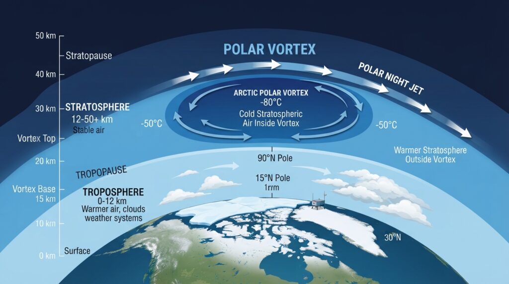
The polar vortex is a large-scale cyclone of cold air that sits high in the atmosphere, centered over Earth’s poles. There are two polar vortices—one over the Arctic and one over Antarctica—though it is the Arctic polar vortex that most directly affects populated regions of the Northern Hemisphere.
Contrary to popular belief, the polar vortex is not a surface-level weather system. It exists primarily in the stratosphere, the layer of the atmosphere that begins roughly 10–15 kilometers above the Earth’s surface and extends to about 50 kilometers. Within the stratosphere, the polar vortex typically sits between 15 and 25 kilometers in altitude.
The vortex is held in place by the polar night jet, a powerful band of stratospheric winds that circulate counterclockwise around the pole in the Northern Hemisphere. During winter, the polar region receives little to no sunlight, causing the stratosphere above the pole to cool dramatically. This temperature contrast between the frigid polar stratosphere and the warmer air at lower latitudes creates a steep pressure gradient—and it is this gradient that sustains the vortex’s rotational strength.
A strong polar vortex acts like a containment system, keeping the coldest Arctic air locked near the pole. When the vortex is robust, its boundary remains tight and circular, and mid-latitude regions tend to experience relatively mild winters.
The Tropospheric Connection and Surface Weather Effects
While the polar vortex itself resides in the stratosphere, its influence extends downward into the troposphere—the lowest layer of the atmosphere, where daily weather occurs. This stratosphere-troposphere coupling is one of the most consequential and least-discussed aspects of the polar vortex system.
The coupling works through a mechanism involving the Arctic Oscillation (AO), a climate index that measures pressure patterns in the Northern Hemisphere. When the polar vortex is strong, the AO tends to be in a “positive phase,” characterized by lower-than-normal pressure over the Arctic and higher pressure over the mid-latitudes. This configuration keeps cold air bottled up near the pole and steers storm tracks northward.
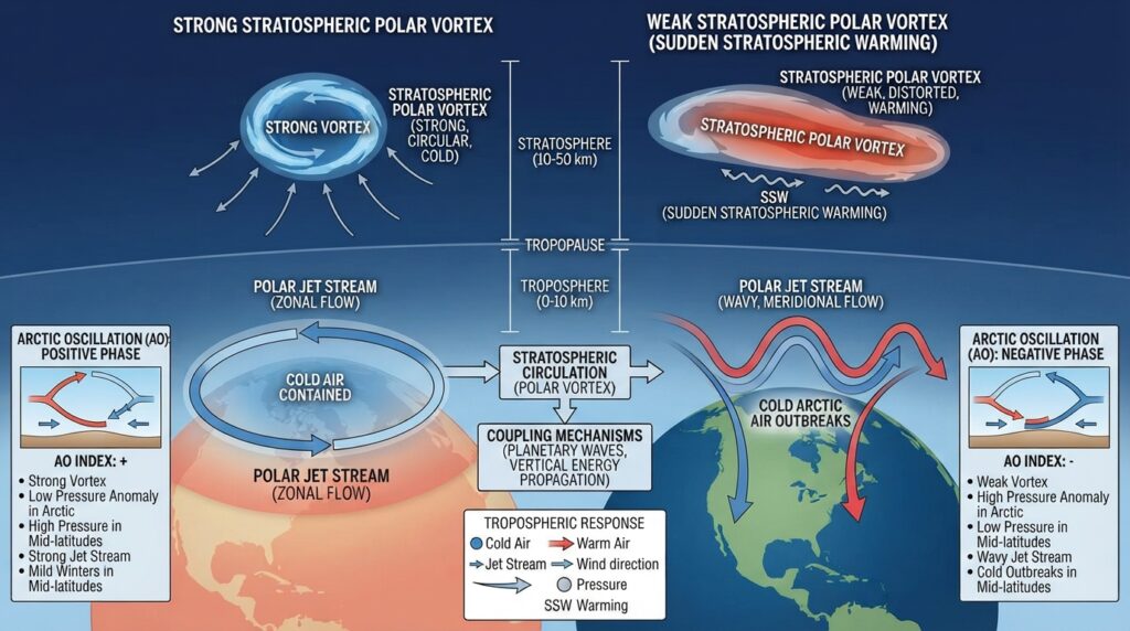
When the polar vortex weakens, the AO shifts to a “negative phase.” Pressure over the Arctic rises, the jet stream becomes wavy and erratic, and cold Arctic air descends toward lower latitudes. This is when regions like the central United States, Western Europe, and parts of Asia experience sudden, severe cold snaps—events popularly associated with a “polar vortex outbreak.”
It is worth emphasizing a common point of confusion: during these cold outbreaks, the polar vortex has not “moved south.” Rather, its disruption allows Arctic air masses that it normally contains to spill equatorward. The vortex weakens; the cold spreads.
Sudden Stratospheric Warming Events
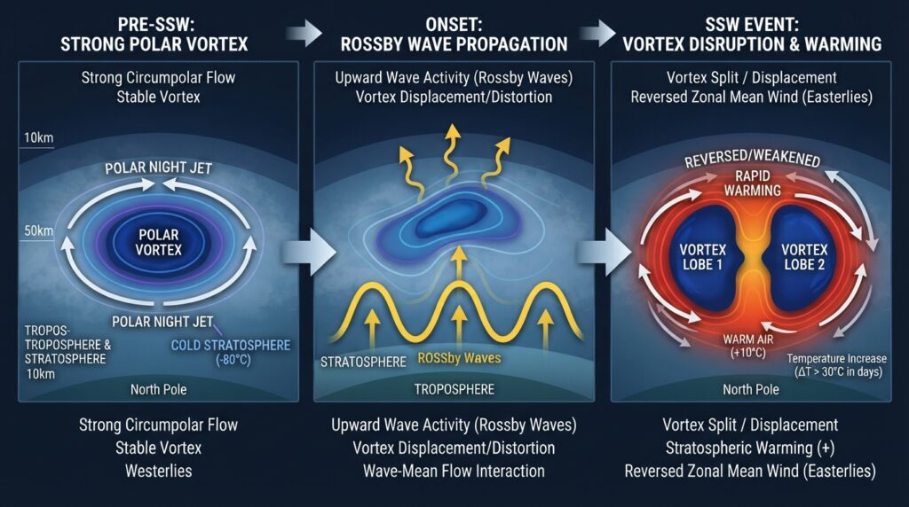
The most dramatic disruptions to the polar vortex are caused by sudden stratospheric warming (SSW) events—rapid and intense warming episodes in the stratosphere that can cause the polar vortex to weaken, split, or even temporarily reverse its circulation.
During an SSW event, stratospheric temperatures over the Arctic can rise by as much as 30–50°C within just a few days—an extraordinary change for a region that is normally locked in extreme cold. These events are triggered by large-scale atmospheric waves, called planetary waves or Rossby waves, that originate in the troposphere and propagate upward into the stratosphere.
When these waves are particularly strong, they disrupt the polar night jet, eroding the temperature gradient that sustains the vortex. The vortex may elongate, become displaced from the pole, or split into two smaller vortices. In major SSW events—classified as those in which the stratospheric winds reverse from westerly to easterly—the downstream effects on surface weather can persist for weeks.
According to research published by the National Oceanic and Atmospheric Administration (NOAA), major SSW events occur roughly six times per decade in the Northern Hemisphere. However, their frequency and intensity are subjects of active scientific investigation, particularly in the context of a warming climate.
Geographic Regions Most Affected by Polar Vortex Disruptions
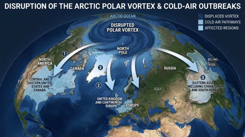
Not all regions experience polar vortex disruptions equally. The geographic distribution of cold air outbreaks depends on the specific pattern of vortex displacement and the configuration of the jet stream at the time of disruption.
North America, particularly the central and eastern United States and Canada, is among the most frequently affected regions. When the polar vortex weakens and the jet stream buckles southward over the continent, temperatures in the Midwest can plunge well below -20°C, with wind chills reaching dangerous extremes. The February 2021 cold wave in Texas—during which temperatures fell to record lows and millions lost power—was directly linked to a polar vortex disruption.
Europe, especially the United Kingdom, Scandinavia, and continental Europe, also experiences significant cold outbreaks during vortex disruptions. The “Beast from the East” events of March 2018, which brought heavy snowfall and bitter cold to the United Kingdom and parts of Western Europe, coincided with a major SSW event that occurred in February of that year.
East Asia, including parts of China, Japan, and South Korea, experiences its own cold air outbreaks during vortex disruptions, typically associated with displacement of the vortex toward the Eurasian sector.
The Role of the Jet Stream in Cold Air Delivery
The polar jet stream is the atmospheric highway through which polar vortex disruptions translate into surface weather events. Situated in the upper troposphere at altitudes of roughly 7–12 kilometers, the jet stream is a fast-moving band of westerly winds that encircles the Northern Hemisphere at mid-latitudes.
Under normal conditions, the jet stream flows in a relatively straight, zonal path from west to east. This configuration keeps cold Arctic air confined to the north and allows warmer, maritime air to dominate mid-latitude regions.
When the polar vortex weakens, the jet stream loses its rigidity and begins to meander in large, looping patterns—a configuration meteorologists describe as high-amplitude Rossby waves. These meanders allow cold Arctic air to dive deep into lower latitudes along the troughs of the wave pattern, while simultaneously drawing warm air poleward along the ridges.
The persistence of these wave patterns is what makes polar vortex-driven cold outbreaks so prolonged. Unlike a transient cold front, a displaced jet stream can hold a region in bitterly cold conditions for days or even weeks before the pattern breaks down.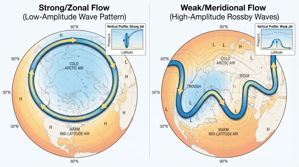
The Polar Vortex and Climate Change
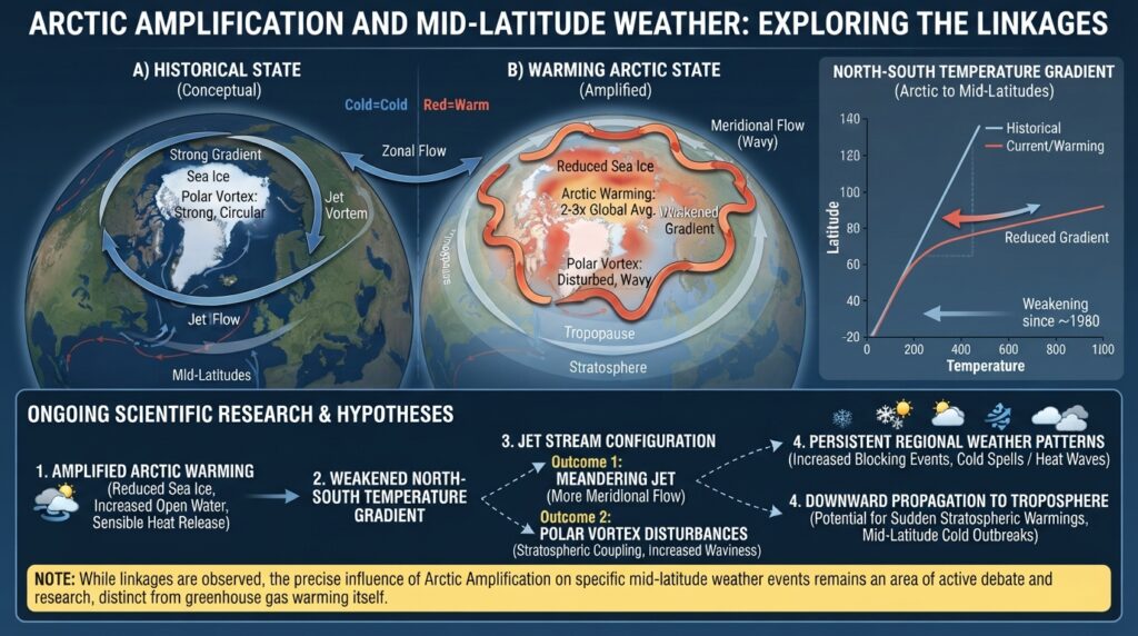
One of the most actively debated questions in atmospheric science concerns the relationship between Arctic warming and polar vortex behavior. As global temperatures rise, the Arctic is warming approximately four times faster than the global average—a phenomenon known as Arctic amplification. This disproportionate warming reduces the temperature gradient between the Arctic and the mid-latitudes, which some scientists argue weakens the polar night jet and makes the polar vortex more susceptible to disruption.
This hypothesis, associated with researchers including Jennifer Francis of the Woodhole Oceanographic Institution, suggests that a warming Arctic could paradoxically lead to more frequent and severe cold outbreaks in mid-latitude regions by destabilizing the polar vortex and increasing the waviness of the jet stream.
However, the scientific community has not reached consensus on this point. Other research suggests that internal atmospheric variability plays a larger role in polar vortex disruptions than Arctic amplification, and that the statistical evidence for a link between Arctic warming and increased cold outbreaks remains mixed. Studies published in journals including Nature Climate Change and the Journal of Geophysical Research: Atmospheres continue to probe this relationship with increasing sophistication.
What is broadly agreed upon is that extreme cold events linked to polar vortex disruptions can co-exist with long-term warming trends. A warming global average temperature does not preclude the occurrence of record-breaking cold snaps in specific regions—a point that underscores the complexity of attributing individual weather events to climate change.
Forecasting Polar Vortex Disruptions
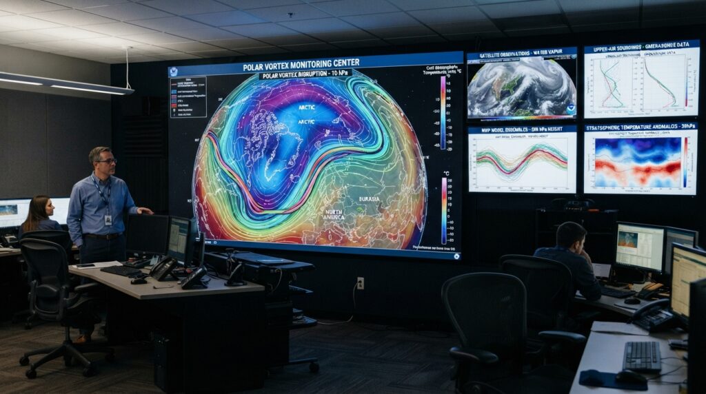
Advances in atmospheric modeling have significantly improved the ability to forecast polar vortex disruptions days to weeks in advance. Modern numerical weather prediction models, including those operated by the European Centre for Medium-Range Weather Forecasts (ECMWF) and NOAA’s National Centers for Environmental Prediction (NCEP), can detect the early signs of stratospheric warming and vortex weakening with reasonable skill up to two weeks ahead.
This extended predictability is particularly valuable for sectors that depend on advance weather planning—including energy utilities, transportation networks, agriculture, and public health systems. A reliable two-week forecast of an impending polar vortex disruption allows grid operators to prepare for surges in heating demand and enables emergency management agencies to issue early warnings.
Despite these advances, predicting exactly which geographic regions will bear the brunt of a vortex-driven cold outbreak remains challenging. The precise path of the displaced vortex, the amplitude of jet stream meanders, and the interaction of the cold air mass with regional topography all introduce uncertainty into localized forecasts.
The Polar Vortex as a Window Into Atmospheric Dynamics
The polar vortex sits at the intersection of stratospheric physics, tropospheric meteorology, and climate science. Its behavior is governed by the same fluid dynamics that shape ocean currents and the rotation of distant planetary atmospheres—making it a compelling subject not only for weather forecasters but for atmospheric scientists studying Earth’s climate system in its entirety.
For the general public, understanding the polar vortex means moving beyond the headlines and recognizing that severe winter weather is not a random event. It is the product of large-scale atmospheric processes, shaped by geography, solar forcing, and an increasingly complex relationship with a changing climate. The next time temperatures plunge and the polar vortex makes front-page news, the story behind the cold is far richer than any single weather alert can convey.