

Monsoon systems are large-scale seasonal wind reversals driven by differential heating between land and ocean surfaces. In synoptic meteorology, they are analyzed through pressure gradients, jet streams, and moisture transport patterns that collectively govern precipitation cycles across tropical and subtropical regions.
Few atmospheric phenomena shape human civilization as profoundly as the monsoon. From the rice paddies of Southeast Asia to the arid plateaus of West Africa, seasonal rainfall governed by monsoon circulation determines agricultural output, water security, and economic stability for billions of people. Understanding how these systems operate—and how meteorologists analyze them at the synoptic scale—is essential for both scientific inquiry and practical forecasting.
Synoptic meteorology concerns itself with large-scale weather patterns observed across broad geographic areas at a given moment in time. It is the discipline that allows forecasters to map pressure systems, fronts, and wind fields spanning thousands of kilometers. Within this framework, monsoon systems represent some of the most complex and consequential circulation patterns on Earth. Their onset, intensity, and withdrawal are governed by a web of interacting factors—solar radiation, sea surface temperatures, upper-level wind patterns, and land surface feedbacks—that synoptic meteorologists work to decode season after season.
This article examines the physical mechanisms behind monsoon circulation, the synoptic-scale features that define monsoon systems, and the major monsoon regimes studied around the world. It also considers how modern meteorological analysis tools have advanced the science of monsoon forecasting.
The Physical Basis of Monsoon Circulation
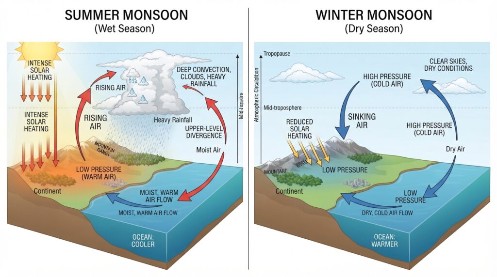
At its core, a monsoon is a seasonal reversal of wind direction driven by differential heating between large continental landmasses and adjacent ocean bodies. During the warmer months, continents absorb solar radiation more rapidly than oceans, causing surface temperatures over land to rise sharply. This differential heating creates a thermal low-pressure system over the heated landmass, while higher pressure persists over the relatively cooler ocean surface.
The resulting pressure gradient drives moisture-laden air from the ocean toward the continent. As this moist air ascends over land—particularly when forced upward by mountain ranges or converging wind patterns—it cools adiabatically, leading to condensation and the release of latent heat. This latent heat release further fuels upward motion, sustaining deep convection and heavy precipitation throughout the monsoon season.
The reverse process occurs in the cooler months. Continental surfaces lose heat rapidly through longwave radiation, generating high pressure over land. The pressure gradient then reverses, drawing dry continental air outward toward the ocean. This is the withdrawal phase—characterized by reduced rainfall, subsiding air, and the return of dry conditions across the affected regions.
This thermal contrast mechanism, first formally described by British astronomer Edmund Halley in 1686, remains foundational to monsoon theory, though modern research has greatly expanded the understanding of how ocean-atmosphere coupling, upper-level circulations, and soil moisture feedbacks amplify or modulate this basic driver.
Synoptic-Scale Features of Monsoon Systems
Analyzing monsoon systems at the synoptic scale involves examining several interconnected atmospheric structures that collectively govern the behavior of seasonal rainfall.
Low-Level Jets and Surface Wind Patterns
One of the most distinctive synoptic features of a mature monsoon is the low-level jet stream—a narrow band of fast-moving air at lower atmospheric levels that acts as the primary conveyor of moisture from ocean to continent. The Somali Jet, for instance, is a low-level jet that intensifies dramatically during the South Asian monsoon onset, transporting moisture from the western Indian Ocean across the Arabian Sea toward the Indian subcontinent. Wind speeds within this feature can exceed 25 meters per second, making it a critical driver of precipitation intensity.
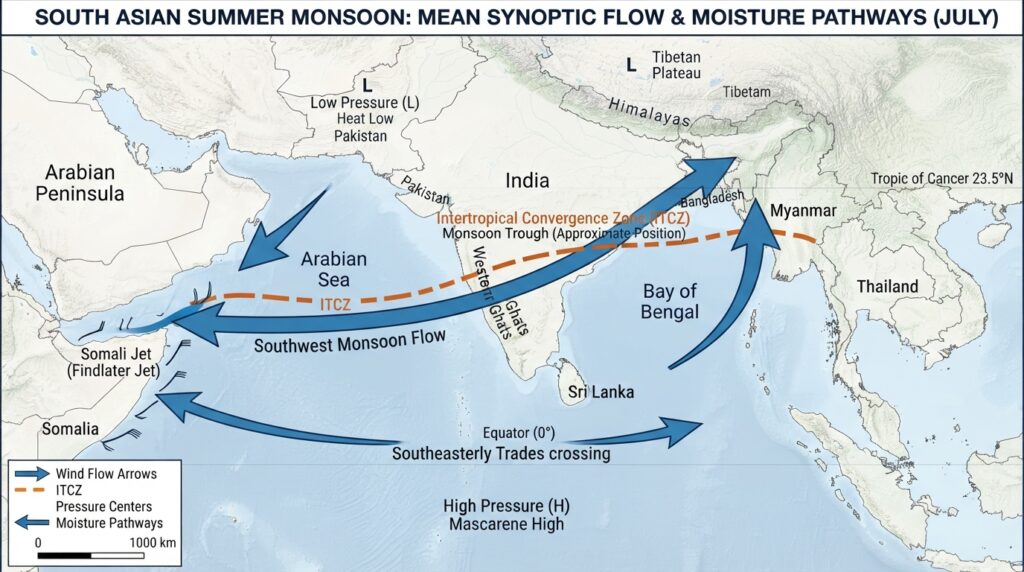
At the surface level, synoptic charts during the active monsoon phase show characteristic wind patterns: southwesterly flows across the Arabian Sea, westerly or southwesterly flows over the Bay of Bengal, and a well-defined Intertropical Convergence Zone (ITCZ) positioned over or north of the equator. The ITCZ marks the region where trade winds from the Northern and Southern Hemispheres converge, creating a persistent band of convective activity and rainfall.
The Subtropical High-Pressure Systems
Monsoon circulation does not operate in isolation—it is embedded within the broader general circulation of the atmosphere. Subtropical high-pressure systems, particularly the Mascarene High over the southern Indian Ocean and the Azores High in the Atlantic, play a pivotal role in directing the flow of moisture into monsoon regions. The positioning and intensity of these anticyclones influence the strength of low-level cross-equatorial flow and, by extension, rainfall distribution over monsoon areas.
During years when subtropical highs are anomalously strong or displaced, the monsoon circulation can intensify or weaken significantly, leading to flood or drought conditions far removed from the highs themselves.
Upper-Level Circulation and the Tropical Easterly Jet
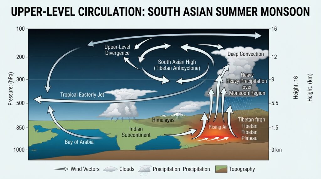
At higher levels of the troposphere, the monsoon is associated with a distinct upper-level anticyclone positioned over the Tibetan Plateau—a feature known as the South Asian High or Tibetan Anticyclone. Flanking this anticyclone to its south is the Tropical Easterly Jet (TEJ), a powerful upper-level wind stream that flows westward across the tropics during the boreal summer.
The TEJ promotes upper-level divergence over South Asia and Africa, which helps sustain the ascending motion and deep convection associated with active monsoon conditions. Weakening of the TEJ has been statistically linked to deficient monsoon rainfall over India and Sahelian Africa, making it an important diagnostic tool for seasonal forecasters.
Monsoon Depressions and Low-Pressure Systems
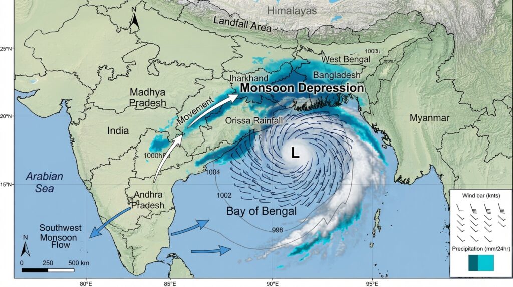
Within the broader monsoon flow, synoptic-scale disturbances—commonly referred to as monsoon depressions—are responsible for a disproportionate share of total seasonal rainfall. These systems form over warm ocean surfaces, often in the Bay of Bengal, and track inland carrying intense precipitation. A single monsoon depression can deliver 200–300 millimeters of rainfall over affected regions within 24 to 48 hours.
Unlike tropical cyclones, monsoon depressions are relatively weak vortices without a clearly defined eye structure. They are, however, efficiently fueled by the ambient moisture and instability of the monsoon environment. Identifying their genesis signals and tracking their movement is a central task in operational monsoon forecasting.
Major Monsoon Systems of the World
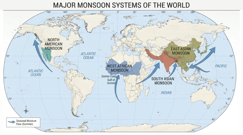
While the South Asian monsoon receives the most scientific attention, monsoon circulations exist across several regions of the globe, each with its own synoptic characteristics.
The South Asian Monsoon
The South Asian monsoon is the most studied and hydrologically significant monsoon system on Earth. It affects the Indian subcontinent, the Bay of Bengal, and parts of the Arabian Sea between June and September. Its onset over the Kerala coast of India, typically around June 1, is considered a benchmark event in regional meteorology and is tracked through a composite index of rainfall, outgoing longwave radiation, and wind shear.
The Himalayas and Western Ghats impose significant orographic controls on rainfall distribution, creating intense precipitation on windward slopes and rain shadow conditions on leeward sides. The interaction between the monsoon circulation and these mountain barriers is a key element of synoptic analysis during the monsoon season.
The East Asian Monsoon
The East Asian monsoon operates over China, Korea, Japan, and neighboring regions. Its structure differs somewhat from the South Asian system due to the influence of mid-latitude dynamics and the proximity of the subtropical jet stream. A particularly notable feature is the Meiyu-Baiu front—a quasi-stationary rainfall band that persists over eastern China and Japan in early summer, responsible for chronic flooding events in these regions.
Upper-level ridging associated with the Western Pacific Subtropical High governs the northward advance of the Meiyu-Baiu front, and shifts in this high’s position have been linked to dramatic inter-seasonal variability in rainfall distribution across East Asia.
The West African Monsoon
The West African monsoon governs rainfall over the Sahel and Guinea Coast regions. Its defining synoptic feature is the Inter-Tropical Discontinuity (ITD)—the surface boundary between southwesterly moisture-laden monsoon air from the Atlantic and dry, dusty northeasterly Harmattan winds from the Sahara.
The northward migration of the ITD during boreal summer determines when and where the rains arrive across West Africa. Simultaneously, the African Easterly Jet at mid-levels generates African Easterly Waves—synoptic-scale disturbances that serve as precursors to rainfall events and, in some cases, Atlantic tropical cyclogenesis.
The North American Monsoon
Often underappreciated in global discussions, the North American monsoon brings substantial summer rainfall to the southwestern United States and northwestern Mexico. Driven by thermal low pressure over the Sonoran Desert and moisture influx from the Gulf of California and Gulf of Mexico, this system transforms desert landscapes into temporarily lush environments from July through September. Synoptic analysis of the North American monsoon requires careful attention to the upper-level ridge position over the region, as shifts in ridge placement strongly control moisture transport pathways.
Modern Tools in Synoptic Monsoon Analysis
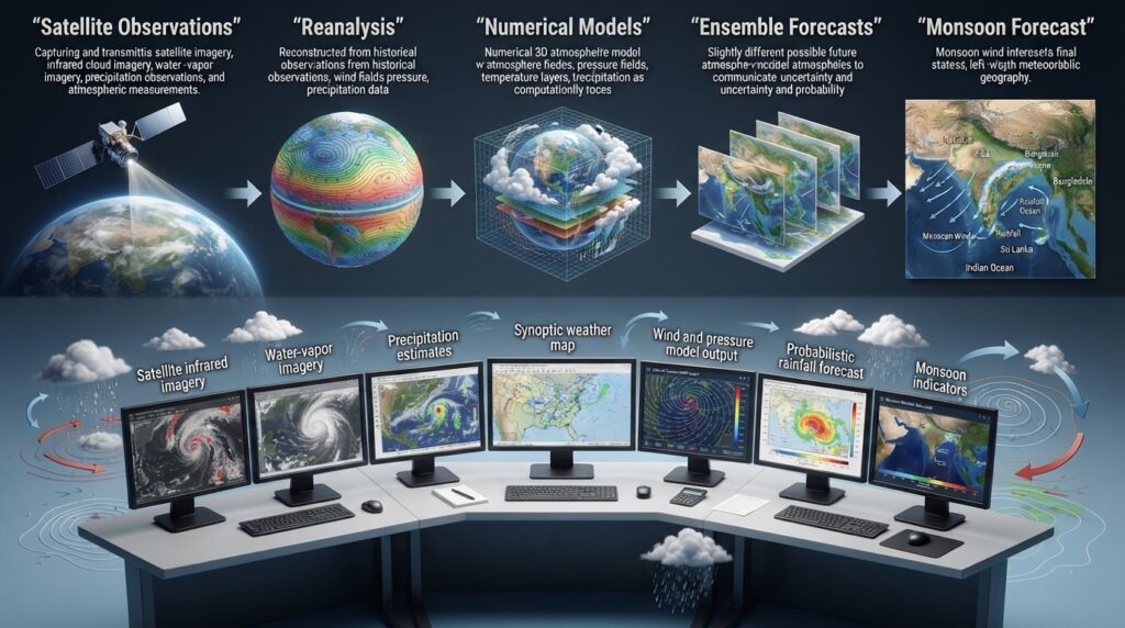
Advances in observational technology and numerical weather prediction have transformed the way meteorologists analyze and forecast monsoon systems. Satellite-derived products—including infrared imagery, water vapor channels, and microwave-based precipitation estimates—provide near-real-time insight into convective organization, moisture distribution, and cloud-top temperatures across vast oceanic and continental areas.
Reanalysis datasets, such as ERA5 produced by the European Centre for Medium-Range Weather Forecasts (ECMWF), allow researchers to reconstruct atmospheric states over decades, enabling rigorous study of monsoon variability and long-term trends. These datasets have been instrumental in confirming observed shifts in monsoon onset timing, intensity distribution, and spatial extent linked to broader climate change signals.
Numerical models—both global and regional—now produce ensemble forecasts that quantify uncertainty in monsoon predictions weeks in advance. Extended-range forecasting of monsoon active and break spells, once considered beyond practical reach, has become a routine operational product in countries like India, where the India Meteorological Department issues multi-week probabilistic guidance for agricultural and water resource planning.
The Significance of Monsoon Research in a Changing Climate
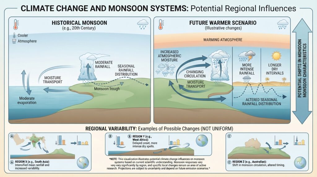
Monsoon systems are responding to a warming climate in ways that are not yet fully understood. Observational records indicate that monsoon precipitation is becoming more intense but less frequent in some regions—a pattern consistent with the thermodynamic expectation that a warmer atmosphere holds more moisture, intensifying precipitation when it occurs. At the same time, circulation changes driven by differential warming between the Arctic and tropics may alter jet stream positioning, with downstream effects on monsoon system behavior.
Understanding these shifts requires the integration of synoptic meteorology with climate science—a convergence that is reshaping how the field approaches monsoon research. As extreme rainfall events become more impactful and the consequences of monsoon variability grow in scale, the synoptic analysis of these systems will only grow in scientific and societal importance.
Concluding Perspectives on Monsoon Meteorology
Monsoon systems sit at the intersection of fundamental atmospheric physics and real-world human consequence. Their analysis through the lens of synoptic meteorology reveals a rich tapestry of interacting features—jets, pressure systems, convective disturbances, and large-scale circulations—that together produce one of Earth’s most powerful seasonal phenomena.
For meteorologists, improving the precision of monsoon forecasts remains both a scientific challenge and a humanitarian imperative. For policymakers and resource managers, understanding the synoptic drivers of monsoon variability offers a pathway to more resilient planning. And for anyone seeking to understand how the atmosphere works at its grandest scales, the monsoon offers a compelling and endlessly instructive case study.
The field continues to evolve rapidly, driven by better data, more powerful models, and sharper scientific questions. What remains constant is the monsoon itself—arriving each year with the reliability of the seasons, and the capacity to reshape landscapes, livelihoods, and scientific understanding all at once.