

Mid-latitude cyclones are large-scale, low-pressure weather systems that form between 30° and 60° latitude. Driven by temperature contrasts between polar and tropical air masses, these cyclones produce much of the precipitation and severe weather experienced across the temperate regions of Earth.
Few atmospheric phenomena shape the daily weather of the mid-latitudes more profoundly than mid-latitude cyclones. Spanning hundreds to thousands of kilometers in diameter, these powerful low-pressure systems are responsible for the stormy, changeable weather patterns that characterize regions such as the central United States, Western Europe, southern Australia, and large parts of Asia. Unlike their tropical counterparts—which derive energy from warm ocean water—mid-latitude cyclones are fueled by horizontal temperature gradients between contrasting air masses.
Understanding how these systems form, evolve, and eventually dissipate is essential not only for meteorologists but also for anyone interested in the physical processes that govern Earth’s climate. Mid-latitude cyclones transport heat from the equator toward the poles, balance the global energy budget, and deliver the rainfall and snowfall that sustain agriculture and freshwater resources across the temperate world. Their behavior influences aviation, shipping, agriculture, and emergency management on a daily basis.
This article provides a thorough overview of mid-latitude cyclones—from the atmospheric conditions that give rise to them, to the stages of their life cycle, the weather patterns they produce, and their broader significance within the Earth system.
The Atmospheric Setting for Mid-Latitude Cyclone Development
Mid-latitude cyclones develop within a zone of the atmosphere known as the mid-latitudes or the temperate zone, broadly defined as the band between approximately 30° and 60° north and south of the equator. This region is characterized by a persistent clash between cold polar air masses moving toward lower latitudes and warm tropical air masses advancing poleward. The boundary between these contrasting air masses is known as the polar front, and it is along this boundary that mid-latitude cyclones most commonly develop.
The polar front is not a static feature. It shifts seasonally—moving equatorward in winter as polar air masses strengthen and retreating poleward in summer. Along this boundary, the atmosphere is inherently unstable. Temperature contrasts generate strong horizontal pressure gradients and wind shear, creating the conditions necessary for cyclogenesis—the process by which a cyclone forms and intensifies.
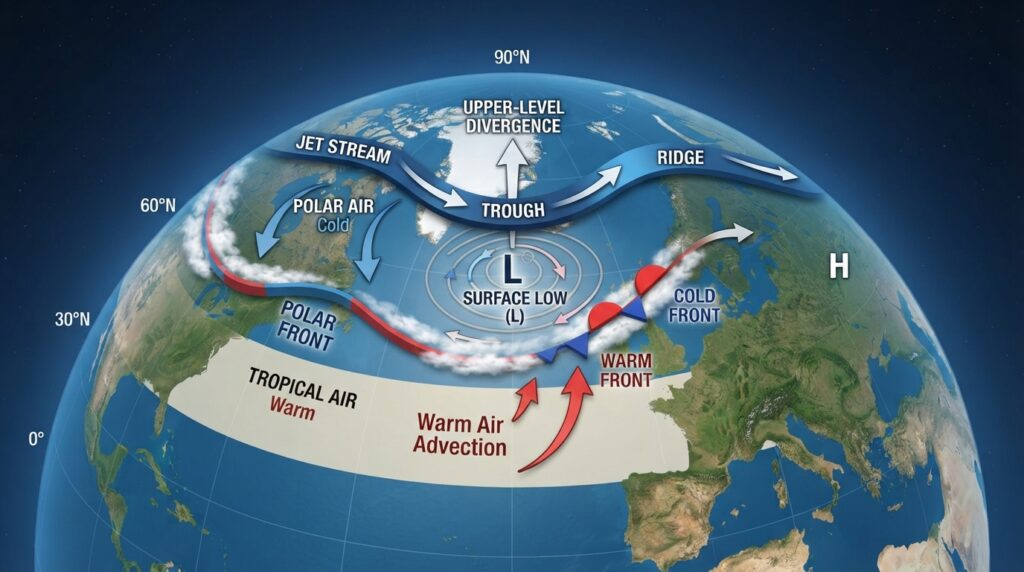
The jet stream, a fast-flowing current of air located in the upper troposphere, plays a critical role in guiding and intensifying mid-latitude cyclones. The jet stream flows in a wave-like pattern, with ridges (northward bulges) and troughs (southward dips). Surface cyclones typically develop beneath jet stream troughs, where upper-level divergence promotes the upward motion of air and the lowering of surface pressure.
The Polar Front Theory and Norwegian Cyclone Model
The foundational framework for understanding mid-latitude cyclone development was established by Norwegian meteorologists Jacob Bjerknes and Halvor Solberg in 1922. Their model, known as the Norwegian cyclone model, described the life cycle of an extratropical cyclone in terms of frontal boundaries and air mass interactions.
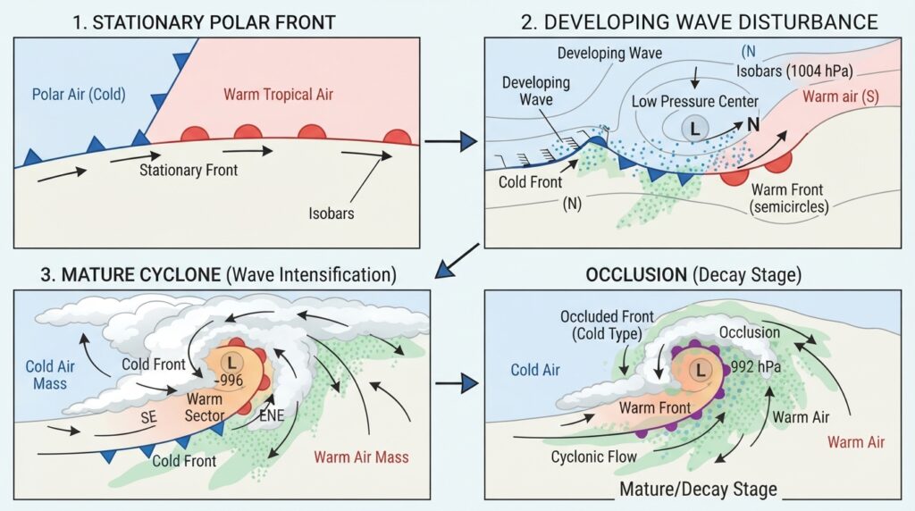
According to this model, a mid-latitude cyclone begins as a stationary or slow-moving frontal boundary between polar and tropical air. A small perturbation—triggered by upper-level dynamics or surface topography—initiates a wave-like disturbance along the front. As this wave amplifies, a counterclockwise circulation develops in the Northern Hemisphere (clockwise in the Southern Hemisphere) around a deepening center of low pressure.
Two distinct frontal boundaries emerge from this process: a cold front, where cold polar air advances beneath and displaces warm air, and a warm front, where warm air gradually rises over retreating cold air. Between these two fronts lies the warm sector—a wedge of warm, moist air that feeds the cyclone’s energy. The Norwegian model remains a foundational teaching tool in meteorology, though modern research has refined and expanded upon its principles.
The Life Cycle of a Mid-Latitude Cyclone
Mid-latitude cyclones progress through a well-defined series of developmental stages, each associated with distinct changes in structure, pressure, and weather.
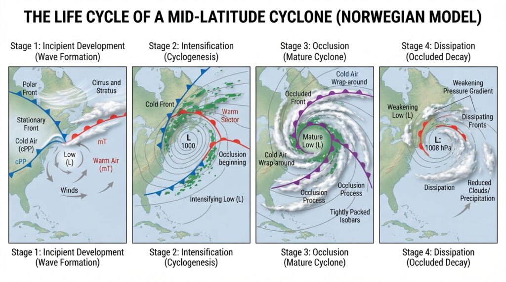
Stage 1: Incipient Development
The initial stage involves the formation of a small wave disturbance along the polar front. Surface pressure begins to fall at the developing center, and wind patterns start to organize around the low. At this stage, the system is relatively weak and its weather impacts are limited.
Stage 2: Intensification and Deepening
As upper-level divergence strengthens, the surface low deepens rapidly—a process sometimes called explosive cyclogenesis or a “weather bomb” when central pressure drops by 24 hectopascals or more within 24 hours. The cold front advances more rapidly than the warm front, and the warm sector narrows. Precipitation intensifies, with heavy rain or snow along the fronts and strong winds around the low center.
Stage 3: Occlusion
Eventually, the faster-moving cold front catches up with the warm front, lifting the warm sector air off the surface entirely. This process—known as occlusion—marks the beginning of the cyclone’s decay. The energy source that sustained the cyclone is cut off, and the system begins to fill (i.e., central pressure rises).
Stage 4: Dissipation
In the final stage, the cyclone weakens and loses its organized structure. The fronts become indistinct, wind speeds decrease, and precipitation tapers off. The remnant system may linger for several days before fully dissipating or merging with another weather feature.
Weather Patterns Associated with Mid-Latitude Cyclones
The weather produced by a mid-latitude cyclone varies significantly depending on a location’s position relative to the storm center and its associated fronts. Recognizing these patterns is fundamental to understanding weather forecasting across the temperate latitudes.
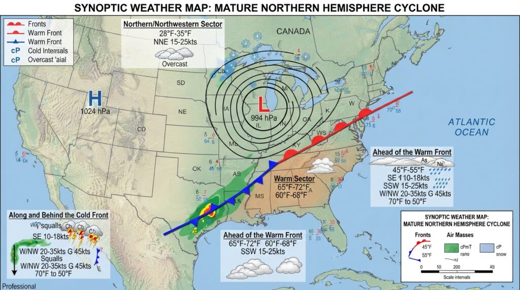
Ahead of the warm front, conditions typically include thickening cloud cover, gradually falling pressure, and steady precipitation—often light rain or snow that can persist for many hours. Visibility may be poor, and fog is common near the surface.
Within the warm sector, temperatures rise noticeably, humidity increases, and precipitation generally eases, though low cloud and drizzle may persist. Winds often shift to a southerly or southwesterly direction in the Northern Hemisphere.
Along and behind the cold front, conditions change rapidly. Towering cumulonimbus clouds can produce heavy precipitation, strong gusty winds, thunder, and occasionally severe weather including hail or tornadoes. As the cold front passes, temperatures fall sharply, pressure rises, and skies gradually clear.
To the north and northwest of the center (in the Northern Hemisphere), cold air is drawn southward, sometimes delivering heavy snowfall and bitter wind chills to affected regions.
The Role of Mid-Latitude Cyclones in the Global Climate System
Mid-latitude cyclones are not isolated weather events—they are integral components of the global atmospheric circulation. By transporting warm, moist air poleward and cold, dry air equatorward, these systems help redistribute the energy imbalance between the tropics and the poles. Without this poleward energy transport, equatorial regions would accumulate heat indefinitely while polar regions cooled without limit.
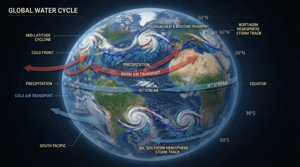
Mid-latitude cyclones are also major contributors to the global water cycle. A single well-developed cyclone can deliver enormous quantities of precipitation across a wide area, replenishing reservoirs, rivers, and groundwater systems. In semi-arid regions, storm tracks that bring cyclonic rainfall are closely monitored for their agricultural implications.
Climate scientists study mid-latitude cyclone activity as a key indicator of broader climate change. Research published in journals such as Nature Climate Change and Geophysical Research Letters has examined how rising global temperatures may alter the frequency, intensity, and geographic distribution of these systems. Some studies suggest a poleward shift in storm tracks under warmer climate conditions, with potential implications for precipitation patterns in both the mid-latitudes and polar regions.
Factors That Influence Mid-Latitude Cyclone Intensity and Track
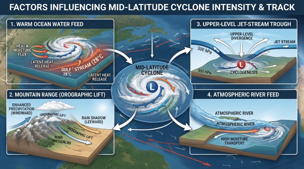
Several physical and dynamic factors govern how intense a mid-latitude cyclone becomes and the path it follows.
Sea surface temperatures significantly influence cyclones that develop over or track across ocean basins. Warmer ocean surfaces increase the supply of heat and moisture to the overlying atmosphere, potentially intensifying the system.
Orographic effects occur when cyclones interact with mountain ranges. As air is forced upward over elevated terrain, precipitation intensifies on the windward side, while dry, descending air produces rain shadows on the leeward side. The Rocky Mountains, the Alps, and the Southern Alps of New Zealand all exert notable orographic influences on passing cyclones.
Upper-level trough depth and jet stream configuration determine how much upper-level support a developing surface cyclone receives. Deep, amplified troughs tend to produce more intense cyclones, while flat jet stream patterns are associated with weaker, less organized systems.
Moisture availability is another critical variable. Cyclones drawing on a rich supply of moisture—often channeled from tropical regions via atmospheric rivers—can produce exceptional rainfall totals and flooding.
Mid-Latitude Cyclones and Severe Weather Risks
While mid-latitude cyclones are a routine feature of temperate weather, they can generate significant hazards under certain conditions. High winds associated with deep cyclones can cause structural damage, power outages, and dangerous maritime conditions. Blizzard conditions may develop when cold air, strong winds, and heavy snowfall combine on the northern or northwestern flank of a winter cyclone.
Flooding is another major risk. Slow-moving or stationary cyclones can deliver prolonged, heavy rainfall over the same area, overwhelming drainage systems and rivers. In the United States, extratropical cyclones—including nor’easters along the Atlantic coast—are among the most costly and impactful weather events of the year. The European windstorms that periodically affect the British Isles and northwestern Europe are also driven by intense mid-latitude cyclonic systems.
The Continuing Relevance of Cyclone Research and Forecasting
Advances in numerical weather prediction have dramatically improved the ability to forecast mid-latitude cyclones days in advance. Modern computer models—such as the European Centre for Medium-Range Weather Forecasts (ECMWF) model and the National Oceanic and Atmospheric Administration’s (NOAA) Global Forecast System (GFS)—simulate the atmosphere with remarkable accuracy, providing forecasters with detailed guidance on cyclone tracks, intensities, and associated weather.
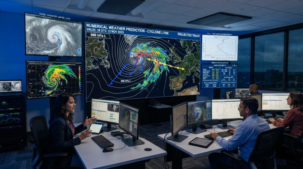
Satellite imagery, Doppler radar, weather balloons, and surface observation networks collectively provide the real-time data that feeds these models. Research continues to refine the understanding of cyclogenesis, frontal dynamics, and the interactions between mid-latitude cyclones and other atmospheric phenomena such as blocking high-pressure systems and atmospheric rivers.
The Enduring Significance of Mid-Latitude Cyclones
Mid-latitude cyclones represent one of the atmosphere’s most powerful and consequential phenomena. They shape the climate of the temperate zones, govern the seasonal rhythm of storms and calms, and play an irreplaceable role in redistributing energy and moisture across the planet. Their influence extends from daily weather forecasts to long-term climate projections, from agricultural planning to disaster preparedness.
A deeper understanding of these systems—how they form, how they evolve, and how they interact with a changing climate—remains one of the central challenges and priorities of atmospheric science. For students, professionals, and engaged citizens alike, mid-latitude cyclones offer a compelling window into the complexity and dynamism of Earth’s atmosphere.