

The jet stream is a fast-moving band of air in the upper atmosphere, typically flowing west to east at speeds of 100–250 mph. It shapes daily weather, steers storms, and influences seasonal climate patterns across the Northern and Southern Hemispheres. Climate change is disrupting its behavior, with wide-ranging consequences.
Few atmospheric phenomena shape life on Earth as quietly—or as powerfully—as the jet stream. Every storm system that rolls across a continent, every unexpected cold snap in spring, every heatwave that lingers far too long can often be traced back to this invisible river of wind. Yet despite its enormous influence, the jet stream remains poorly understood outside scientific circles.
This article breaks down what the jet stream is, how it forms, and why it matters—for weather forecasting, aviation, agriculture, and the future of the planet’s climate. Whether you’ve heard the term on the evening news or encountered it in a geography textbook, what follows will give you a clear, comprehensive understanding of one of nature’s most consequential forces.
The Definition and Basic Characteristics of the Jet Stream
The jet stream is a narrow band of fast-moving air that flows in a roughly west-to-east direction through the upper levels of the troposphere—the lowest layer of Earth’s atmosphere. Located at altitudes between 6 and 9 miles (approximately 10 to 15 kilometers) above the surface, jet streams travel at average speeds of 100 to 250 miles per hour (160 to 400 km/h), though they can occasionally exceed 275 mph during winter months.
Unlike surface winds, which are highly variable and influenced by local terrain, the jet stream operates on a planetary scale. Its core is relatively narrow—often just a few hundred miles wide—but it can extend for thousands of miles in length, encircling entire hemispheres in a wavy, meandering path.
Jet streams are not uniform tubes of air. They have a distinct core of maximum wind speed surrounded by slower-moving air on their edges. Meteorologists often represent them as elongated ribbons that shift position, intensify, and weaken depending on the time of year and prevailing atmospheric conditions.
The Formation of the Jet Stream
The jet stream forms as a direct consequence of temperature differences between air masses at different latitudes. The fundamental driver is simple: warm air near the equator and cold air near the poles create a significant temperature gradient. According to basic atmospheric physics, air flows from regions of high pressure to low pressure, and these large-scale temperature contrasts generate powerful pressure gradients high in the atmosphere.
As warm air rises near the tropics and cold air sinks near the poles, the atmosphere develops a system of circulation cells—the Hadley, Ferrel, and Polar cells—that organize the flow of air around the planet. The jet stream forms at the boundaries between these circulation cells, where sharp temperature contrasts intensify atmospheric pressure differences and accelerate wind speeds.
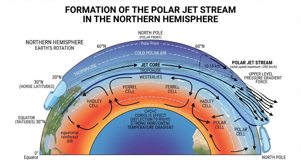
Earth’s rotation also plays a decisive role. The Coriolis effect—a consequence of the planet’s spin—deflects moving air to the right in the Northern Hemisphere and to the left in the Southern Hemisphere. This deflection transforms what might otherwise be a direct north-south flow of air into the characteristic west-to-east motion of the jet stream. The combination of steep temperature gradients and Coriolis deflection produces the concentrated, fast-moving channels of air we identify as jet streams.
The Different Types of Jet Streams
There are four primary jet streams on Earth, organized by hemisphere and latitude.
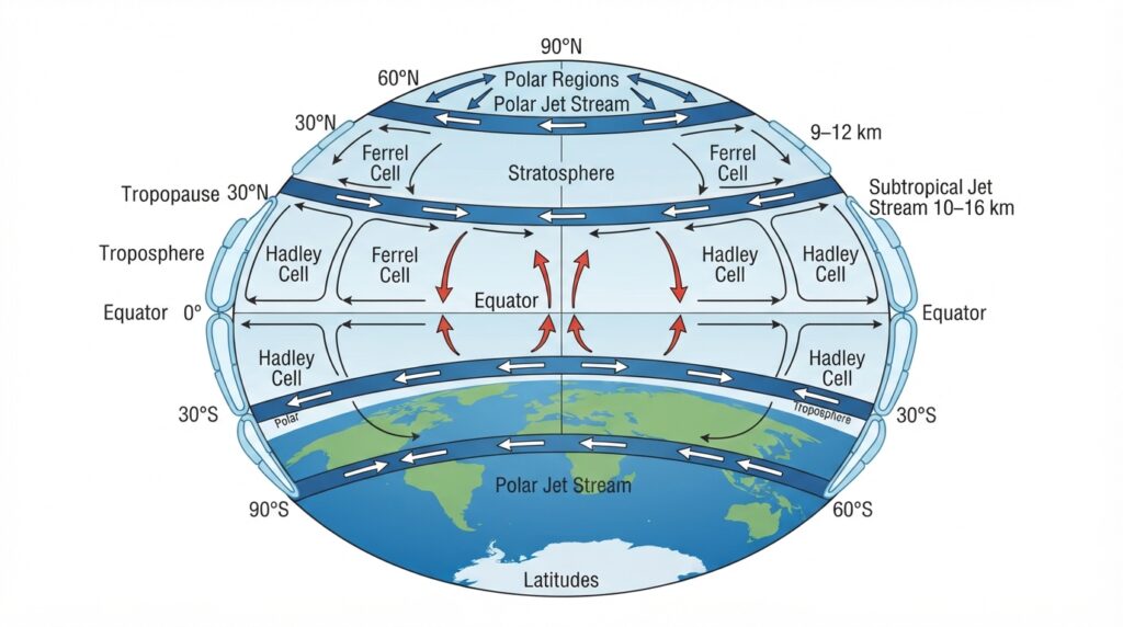
The Polar Jet Streams are the most influential in terms of daily weather. Found in both the Northern and Southern Hemispheres at latitudes between 50° and 60°, polar jet streams form at the boundary between cold polar air and warmer mid-latitude air. These are the most intense and variable jet streams, particularly in the Northern Hemisphere, where they regularly dip as far south as the subtropics during winter.
The Subtropical Jet Streams form closer to the equator, typically between 20° and 30° latitude in both hemispheres. They are generally weaker and more consistent in position than polar jet streams. The subtropical jet stream plays a significant role in the transport of moisture and heat between tropical and mid-latitude regions.
Each of these systems behaves differently across seasons. In winter, jet streams intensify and move equatorward as temperature contrasts between the equator and poles sharpen. In summer, they weaken and shift poleward as the temperature gradient moderates. This seasonal oscillation has profound consequences for weather across continents.
The Role of the Jet Stream in Weather Systems
The jet stream’s influence on surface weather is both direct and far-reaching. Because it flows high above the surface, it acts as a conveyor belt for weather systems, steering storms, redirecting moisture, and separating warm and cold air masses.
Storm tracks are among the most significant effects. Low-pressure systems—the engines of precipitation and wind—tend to develop along or just below the jet stream’s core, where wind shear (the change in wind speed and direction with altitude) is greatest. These storms then follow the jet stream’s path as they travel across a continent, which is why forecasters track jet stream position as a primary indicator of where storms will develop and move.
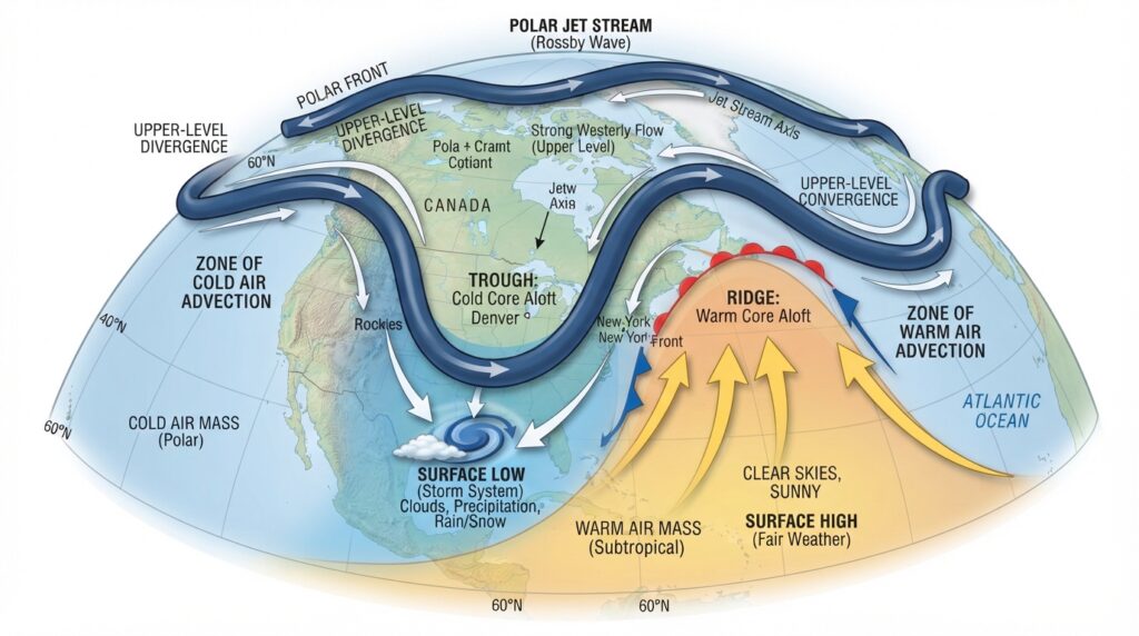
The jet stream also acts as a boundary between contrasting air masses. When the polar jet stream dips far south, it allows cold Arctic air to pour into mid-latitudes, producing sharp temperature drops and winter storms. When it retreats north, warm tropical air surges poleward, bringing unusually mild conditions or even drought.
The waviness of the jet stream—its tendency to form large north-south meanders called Rossby waves—is a critical factor in determining weather extremes. When Rossby waves amplify into large, persistent loops, weather patterns can stagnate. A region sitting beneath a deep trough receives prolonged cold and precipitation, while an area under a persistent ridge bakes in dry, warm conditions. Extended blocking events of this kind are responsible for many of history’s most severe weather episodes, including prolonged droughts, heat domes, and extended cold snaps.
The Jet Stream’s Impact on Aviation
The jet stream has shaped commercial aviation since airlines first recognized its potential in the mid-20th century. Pilots and dispatchers routinely plan routes to take advantage of tailwinds from the jet stream when flying west to east, and to avoid its powerful headwinds when flying in the opposite direction.
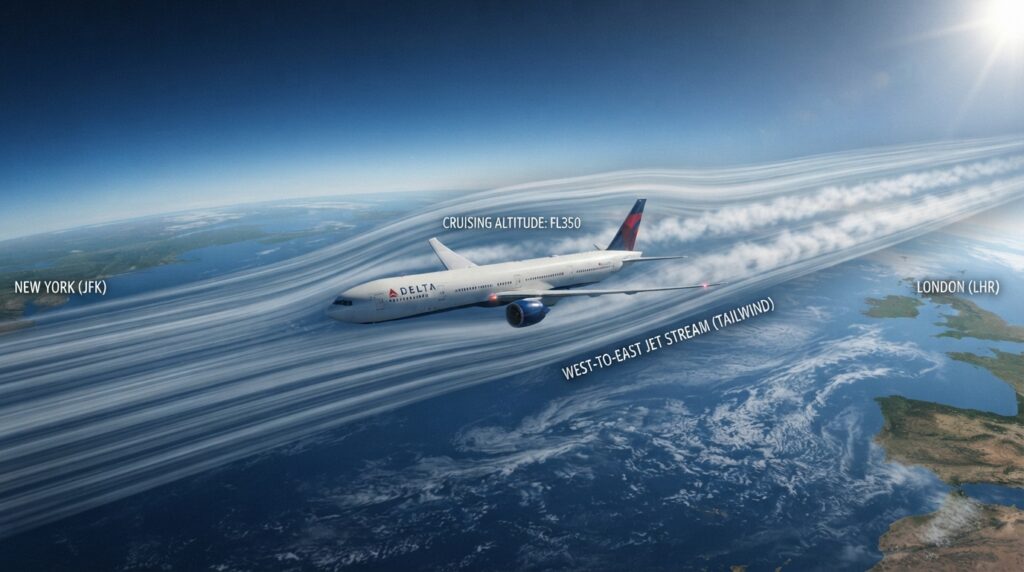
The practical savings are considerable. A transatlantic flight from New York to London benefits enormously from favorable jet stream positioning, with flight times often reduced by 30 to 60 minutes compared to the return journey. This translates directly into fuel savings and reduced emissions. According to the UK’s National Air Traffic Services, airlines save millions of gallons of fuel annually by optimizing flight paths around jet stream conditions.
However, the jet stream also presents hazards. Clear-air turbulence—the abrupt, invisible turbulence that occurs away from clouds and storm systems—is most common near the edges of the jet stream, where wind shear is pronounced. As climate change alters the jet stream’s behavior, research published in Geophysical Research Letters suggests that incidents of severe clear-air turbulence over the North Atlantic have increased significantly in recent decades.
Climate Change and the Disruption of the Jet Stream
The relationship between climate change and the jet stream is an active area of research and one with significant implications for future weather patterns. The core concern centers on Arctic amplification—the phenomenon by which the Arctic is warming two to four times faster than the global average, according to the National Oceanic and Atmospheric Administration (NOAA).
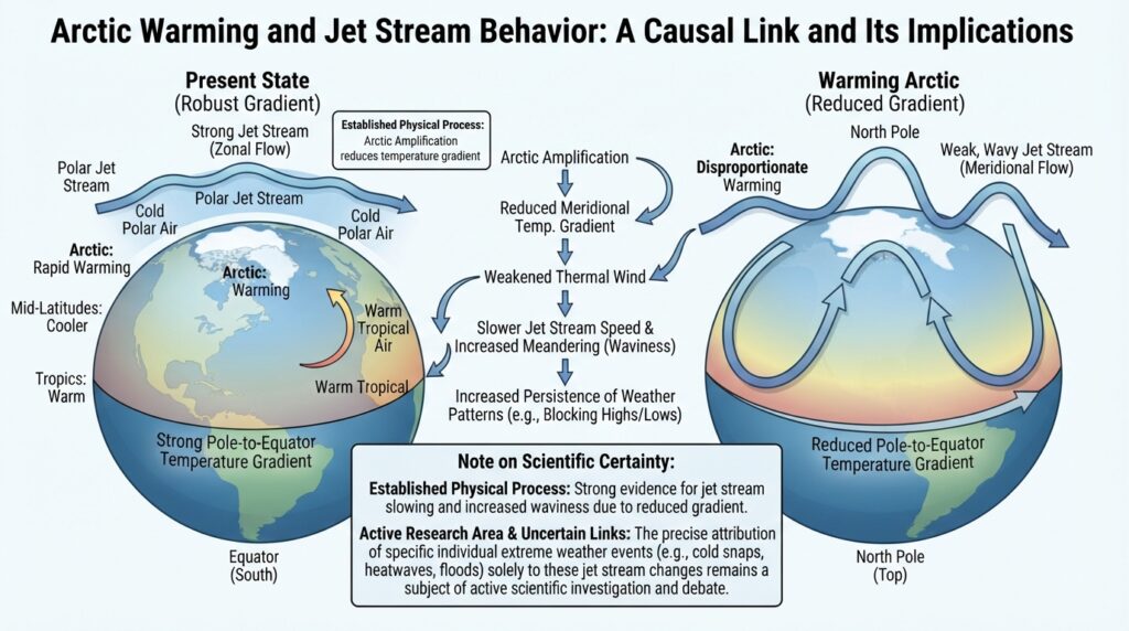
The jet stream’s intensity depends on the temperature difference between the poles and the tropics. As the Arctic warms disproportionately, this temperature gradient weakens. A weaker gradient translates to a slower, more meandering jet stream—one that forms larger, more amplified Rossby waves that tend to persist for longer periods.
Research led by scientists at the Potsdam Institute for Climate Impact Research has suggested that this increased waviness is linked to a greater frequency of extreme weather events. Prolonged heatwaves, such as the devastating European heat wave of 2003 and the Pacific Northwest heat dome of 2021, have been associated with stalled jet stream patterns that trapped hot, dry air over large regions for extended periods. Similarly, recurring cold air outbreaks into the central United States have been linked to a destabilized polar vortex, which interacts closely with the polar jet stream.
It is important to note that the scientific community has not reached full consensus on every aspect of this relationship. Some studies argue that natural variability in jet stream behavior makes it difficult to isolate human-driven changes from long-term oscillations. What is broadly agreed upon, however, is that the Arctic’s rapid warming introduces new dynamics into the polar jet stream that were not present in earlier climate periods.
The Agricultural and Societal Significance of the Jet Stream
The jet stream’s effects extend beyond weather forecasting and aviation into agriculture, water supply, and economic planning. Monsoon systems in South Asia, rainfall distribution in the American Great Plains, and drought cycles in sub-Saharan Africa are all influenced, directly or indirectly, by the positioning and behavior of jet streams.
In North America, the position of the polar jet stream determines whether the Great Plains receive adequate winter snowpack and spring rainfall. Prolonged northward displacement of the jet stream during summer has been associated with drought conditions in the western United States, while an equatorward shift can bring excessive precipitation to the Midwest. For farmers who plan seasons, plant crops, and manage irrigation based on climate expectations, these shifts carry measurable economic consequences.
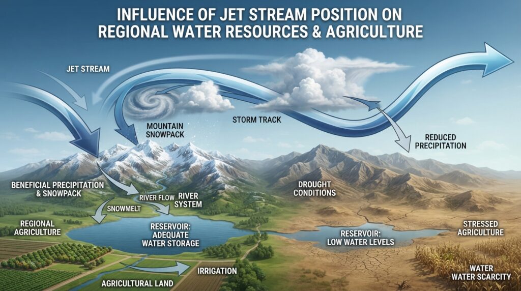
Water resource managers in regions dependent on mountain snowpack face similar challenges. The timing of snowmelt, which sustains rivers and reservoirs through dry summer months, is closely tied to late-winter jet stream behavior. Disruptions to this pattern can compress or extend the snowmelt season in ways that strain water supply infrastructure.
The Ongoing Study of Jet Streams
Atmospheric scientists continue to refine their understanding of jet stream dynamics through a combination of satellite observation, weather balloon data, and high-resolution climate modeling. Improvements in numerical weather prediction have made jet stream forecasting significantly more accurate over the past two decades, extending reliable forecast windows from three or four days to seven or more.
Organizations including NOAA, the European Centre for Medium-Range Weather Forecasts (ECMWF), and the UK Met Office invest substantial resources in monitoring and modeling jet stream behavior. Their work underpins not only daily weather forecasts but also seasonal climate outlooks that inform agriculture, energy demand planning, and disaster preparedness.
Advanced reanalysis datasets now allow scientists to reconstruct historical jet stream patterns over the past century, providing a baseline against which current changes can be measured. This retrospective analysis has confirmed that jet stream behavior in recent decades differs in measurable ways from historical norms—a finding that reinforces the need for continued research and monitoring.
The Jet Stream’s Lasting Relevance in an Evolving Climate
The jet stream is not simply a meteorological curiosity—it is a foundational driver of Earth’s weather and climate. From the trajectory of winter storms to the persistence of summer heat waves, from transatlantic flight times to the adequacy of spring rains, its influence touches nearly every dimension of life in the mid-latitudes.
As the planet warms and the Arctic continues its accelerated transformation, the behavior of the jet stream will remain one of the most consequential—and closely watched—variables in atmospheric science. Understanding how this great river of air operates, how it responds to a warming world, and how its shifts ripple through ecosystems and economies is not an academic exercise. It is essential knowledge for navigating the climate challenges that lie ahead.
Staying informed about jet stream science means engaging with reliable sources: NOAA’s Climate.gov, the ECMWF’s public forecasting tools, and peer-reviewed journals such as Nature Climate Change and Journal of Climate all offer accessible entry points for readers who want to go deeper into this subject.