

Hurricanes rank among the most powerful and destructive weather systems on Earth. Each year, they reshape coastlines, displace millions, and cause billions of dollars in damage—yet the atmospheric processes that create them are surprisingly precise. A hurricane doesn’t just appear. It builds, step by step, when a specific set of oceanic and atmospheric conditions align in exactly the right way.
This article breaks down the science of hurricane formation from start to finish. You’ll learn what conditions are necessary for a tropical cyclone to develop, how it intensifies into a full-scale hurricane, and why certain regions of the world are more vulnerable than others. Whether you’re a student, a weather enthusiast, or simply someone who wants to understand the forces behind the headlines, this guide offers a thorough and accessible explanation.
The Fundamental Ingredients for Hurricane Development
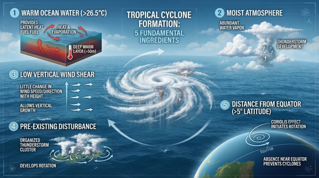
Not every storm becomes a hurricane. For a tropical cyclone to form, several environmental conditions must come together simultaneously. Remove any one of them, and the storm either weakens or fails to develop altogether.
The primary ingredients include:
- Warm ocean water: Sea surface temperatures must be at least 26°C (79°F) to a depth of around 50 meters. This warm water serves as the energy source for the developing storm.
- Atmospheric moisture: High humidity in the lower and middle levels of the atmosphere provides the fuel that keeps convection—rising, warm air—ongoing.
- Low wind shear: Wind shear refers to the change in wind speed and direction at different altitudes. High wind shear disrupts a storm’s vertical structure, while low wind shear allows it to organize and strengthen.
- A pre-existing weather disturbance: Hurricanes almost always begin life as a cluster of thunderstorms or a tropical wave—a disturbance in the atmosphere that provides the initial rotation.
- A location away from the equator: The Coriolis effect, which results from Earth’s rotation, is needed to give the storm its spin. This effect is essentially zero at the equator, which is why hurricanes rarely form within 5 degrees of it.
When all five conditions are present, the atmosphere becomes capable of sustaining and amplifying a developing storm.
The Role of Warm Ocean Water in Fueling a Hurricane
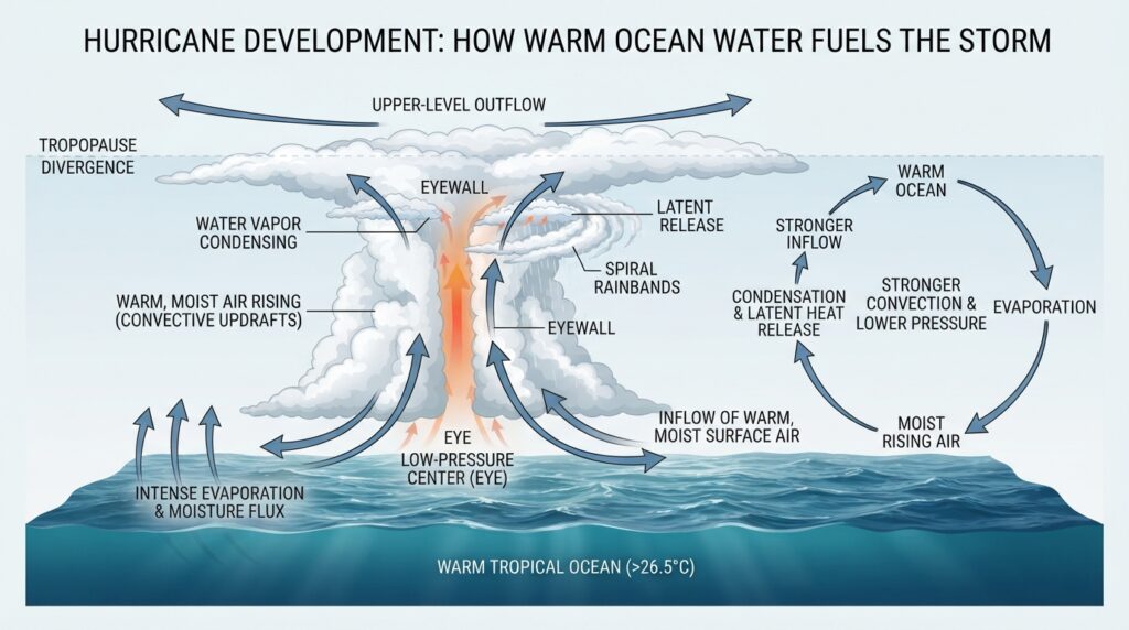
Ocean heat is the engine that drives hurricane formation. When warm, moist air rises from the ocean surface, it creates an area of lower pressure below. Surrounding air rushes in to fill that pressure gap, picks up heat and moisture from the ocean, and rises in turn. This cycle—evaporation, condensation, and heat release—is known as convection, and it’s the core mechanism of hurricane development.
As water vapor rises and cools, it condenses into clouds and releases latent heat. This latent heat warms the surrounding air, making it even more buoyant and causing it to rise further. The result is a self-reinforcing feedback loop: the warmer the ocean, the more energy gets fed into the storm, and the more intense the storm becomes.
This is also why hurricanes weaken rapidly when they move over cooler water or make landfall. Cut off from their oceanic heat source, they lose the energy that sustains them.
From Tropical Disturbance to Tropical Storm: The Stages of Development
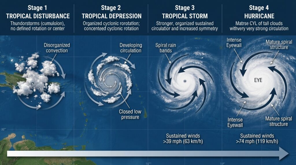
Meteorologists classify tropical cyclones into distinct developmental stages based on wind speed and organization. Understanding these stages helps illustrate how a loose cluster of thunderstorms can evolve into one of nature’s most fearsome phenomena.
Tropical Disturbance
Everything begins with a tropical disturbance—an unorganized mass of thunderstorms with little surface wind circulation. These disturbances frequently develop from African easterly waves, which are atmospheric disturbances that move westward off the African continent into the Atlantic Ocean. According to the National Oceanic and Atmospheric Administration (NOAA), roughly 60 named tropical storms in the Atlantic originate from these easterly waves each decade.
Tropical Depression
When the disturbance becomes more organized and develops a closed circulation pattern with sustained winds of up to 38 mph (61 km/h), it is classified as a tropical depression. At this stage, meteorologists begin tracking it closely and assigning it a number.
Tropical Storm
Once sustained winds reach 39 mph (63 km/h), the system is upgraded to a tropical storm and receives a name. The storm now has a more defined structure, with spiral rain bands beginning to wrap around a developing center of circulation.
Hurricane
A tropical storm becomes a hurricane when sustained winds reach 74 mph (119 km/h) or higher. At this point, the storm has a clearly defined eye—a calm, nearly cloud-free center—surrounded by the eyewall, which contains the most intense winds and rainfall of the entire system.
The Structure of a Mature Hurricane
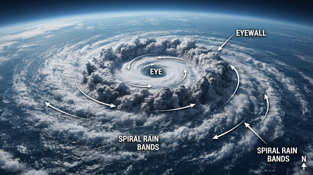
A fully developed hurricane is a remarkably organized system, despite the chaos it produces. Three structural components define a mature hurricane:
The Eye: The eye is the calm, clear center of the storm, typically ranging from 20 to 40 miles (32 to 64 km) in diameter. Pressure inside the eye reaches its lowest point here, and winds are relatively light. The clear skies can be deceiving—the most dangerous part of the storm lies just beyond the eye’s edge.
The Eyewall: Surrounding the eye is the eyewall, a ring of towering thunderstorms. This region contains the hurricane’s strongest winds, highest rainfall rates, and most destructive energy. The eyewall is where the storm’s updrafts are most vigorous, and it’s directly tied to the ocean’s heat input.
The Rain Bands: Extending outward from the eyewall are spiral bands of clouds and thunderstorms called rain bands. These can stretch hundreds of miles from the center and produce heavy rain, strong winds, and tornadoes as the storm makes landfall.
How Hurricanes Intensify: Rapid Intensification and the Eyewall Replacement Cycle
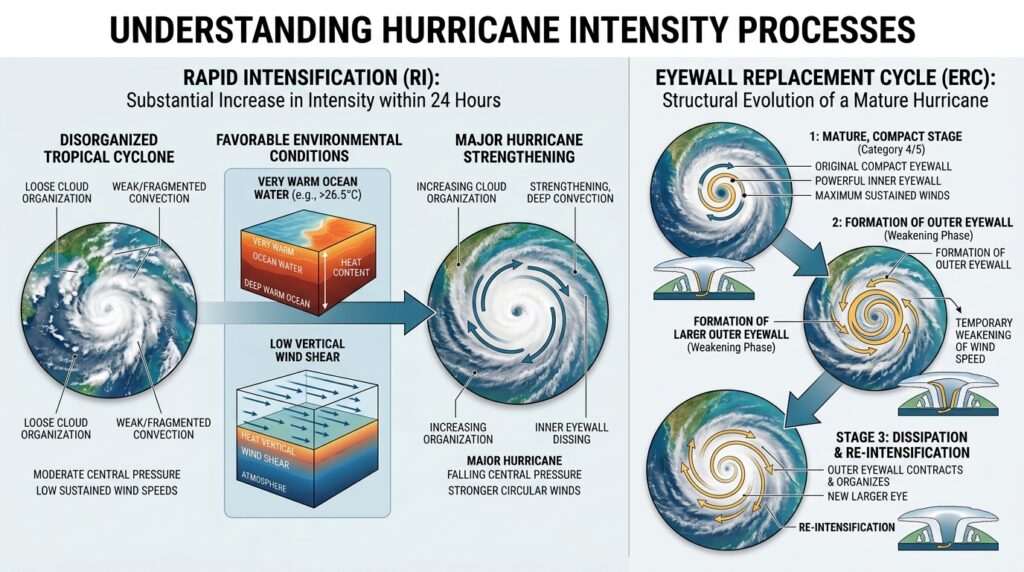
Hurricane intensity is not static. Storms can strengthen or weaken dramatically within short periods, often catching forecasters and communities off guard.
Rapid intensification is defined by the National Hurricane Center (NHC) as an increase in maximum sustained winds of at least 35 mph (56 km/h) within 24 hours. This phenomenon typically occurs when a hurricane moves over exceptionally warm water with low wind shear and high atmospheric moisture. In recent decades, the frequency of rapidly intensifying hurricanes has increased, a trend that climate scientists have linked to rising sea surface temperatures.
Another fascinating process is the eyewall replacement cycle. In strong hurricanes, the outer rain bands can organize into a new eyewall that gradually contracts inward, choking off the original eyewall. During this process, the storm temporarily weakens as the original eyewall dissipates. Once the new eyewall contracts and takes over, the hurricane can re-intensify—sometimes to greater intensity than before.
Geographic Distribution and the Hurricane Season
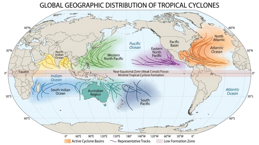
Tropical cyclones occur in multiple ocean basins around the world, where they go by different regional names. In the North Atlantic and eastern North Pacific, they are called hurricanes. In the western North Pacific, they are known as typhoons. In the Indian Ocean and South Pacific, they are referred to as cyclones.
The Atlantic hurricane season officially runs from June 1 to November 30, with peak activity occurring between mid-August and mid-October. According to NOAA, September is statistically the most active month, as sea surface temperatures in the Atlantic reach their annual peak and atmospheric conditions become most favorable for development.
The Gulf of Mexico, Caribbean Sea, and western Atlantic are particularly prone to hurricane activity due to persistently warm waters and favorable atmospheric dynamics. Coastal regions of the Gulf Coast, Florida, and the eastern seaboard of the United States face the greatest hurricane risk in North America.
The Influence of Climate Change on Hurricane Formation
Scientific research has established a clear connection between climate change and several aspects of hurricane behavior. While climate change does not directly increase the total number of tropical storms that form each year, it does influence their characteristics in significant ways.
According to a 2020 study published in the Proceedings of the National Academy of Sciences, the proportion of tropical cyclones reaching Category 3 strength or higher has increased globally over the past four decades. Warmer ocean temperatures driven by climate change provide more energy for storms, while a moister atmosphere allows them to carry and dump more rainfall.
Additionally, rising sea levels amplify the storm surge—the wall of ocean water pushed ashore by hurricane winds—making coastal flooding increasingly severe even from storms that don’t reach the highest wind thresholds. The combination of more intense storms and higher baseline sea levels represents one of the most significant climate-related risks facing coastal communities worldwide.
How Hurricanes Dissipate
Just as specific conditions are required for a hurricane to form, the absence of those conditions causes it to weaken and eventually dissipate. The most common causes of weakening include:
- Landfall: Moving over land cuts the storm off from its oceanic heat source. Friction with the land surface also disrupts the storm’s circulation.
- Cold water upwelling: A slow-moving storm can churn up cooler water from deeper in the ocean, reducing the surface temperature and starving itself of heat.
- Increased wind shear: High-altitude winds that vary strongly in direction or speed can tear apart the storm’s organized structure.
- Dry air intrusion: If dry air from the surrounding environment gets pulled into the storm’s circulation, it suppresses convection and causes the storm to weaken.
Most Atlantic hurricanes that make landfall along the U.S. coast dissipate within a day or two of moving inland, though their remnants can continue producing heavy rainfall and flooding far from the coast.
The Science Behind One of Nature’s Most Powerful Forces
Hurricanes are a product of Earth’s atmosphere and oceans working together in a precise, self-sustaining cycle. Warm ocean water provides the energy. Atmospheric moisture fuels the convection. Low wind shear allows organized structure to develop. The Coriolis effect gives the storm its spin. And once the cycle begins, it can sustain itself for days or weeks—crossing thousands of miles of open ocean before finally losing the conditions it needs to survive.
Understanding how hurricanes form is more than academic. As climate change continues to alter ocean temperatures and atmospheric dynamics, accurate knowledge of hurricane formation mechanisms is essential for improving forecast models, informing public policy, and helping communities prepare for the storms ahead.
Meteorological agencies like NOAA and the National Hurricane Center publish real-time tracking, forecasts, and preparedness resources throughout the hurricane season. Staying informed—and understanding what’s behind the forecast—remains one of the most effective tools available to anyone living in a hurricane-prone region.