

High and low pressure systems are the primary drivers of Earth’s weather patterns. High pressure systems bring stable, clear conditions, while low pressure systems generate clouds, precipitation, and storms. Their continuous interaction—shaped by temperature, geography, and the Coriolis effect—determines regional climate and daily weather across the globe.
Meteorology rests on a deceptively simple foundation: differences in atmospheric pressure drive virtually every significant weather event on Earth. From a calm, sunny afternoon to a devastating hurricane, the forces at work can almost always be traced back to the behavior of high and low pressure systems and how they interact with one another.
Understanding these systems is not merely an academic exercise. Farmers, pilots, sailors, emergency managers, and climate scientists all rely on pressure system dynamics to make critical decisions. At the core of this understanding lies the movement of air masses—vast bodies of atmosphere that carry heat, moisture, and kinetic energy across continents and oceans. Grasping how these systems form, behave, and collide unlocks a far deeper appreciation of why the sky looks the way it does on any given day.
This article explores the mechanics of high and low pressure systems, their defining characteristics, and the complex interactions that shape weather patterns across the planet.
The Nature of Atmospheric Pressure
Atmospheric pressure is the weight of the air column above any given point on Earth’s surface. Measured in millibars (mb) or hectopascals (hPa), standard sea-level pressure sits at approximately 1013.25 hPa. Deviations from this baseline—whether upward or downward—define the pressure systems that meteorologists track on synoptic weather charts.
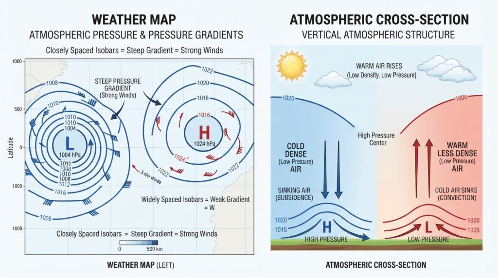
Pressure gradients, or the rate of pressure change across a horizontal distance, determine wind speed. Tightly packed isobars (lines of equal pressure on a weather map) signal steep gradients and strong winds. Widely spaced isobars indicate gentle, gradual pressure transitions and calmer conditions. This gradient acts as the fundamental engine that sets air in motion.
Temperature plays a decisive role in creating pressure differences. Warm air is less dense than cold air and tends to rise, reducing surface pressure. Cold air is denser and sinks, increasing surface pressure. This temperature-density relationship explains why pressure systems form where they do and why they behave so differently from one another.
Characteristics of High Pressure Systems
A high pressure system, or anticyclone, forms when air sinks toward Earth’s surface from higher altitudes. As this descending air compresses, it warms—a process governed by adiabatic heating. Warming suppresses cloud formation, which is why high pressure systems are strongly associated with clear skies, sunshine, and dry conditions.
At the surface, air flows outward from the center of a high pressure system. Due to the Coriolis effect—caused by Earth’s rotation—this outward flow moves clockwise in the Northern Hemisphere and counterclockwise in the Southern Hemisphere. This rotational pattern is one of the defining signatures of anticyclones on weather maps.
High pressure systems tend to be slow-moving and persistent. They can dominate a region’s weather for days or even weeks, leading to extended periods of settled conditions. During summer, prolonged anticyclones can cause heatwaves. In winter, the same clear skies that accompany high pressure allow heat to radiate away from the surface at night, producing sharp frosts and below-freezing temperatures.
Two broad categories of high pressure systems exist. Thermal highs develop over cold land masses where surface air cools, becomes dense, and sinks. Dynamic highs, by contrast, form through upper-level convergence in the atmosphere—air piling up at altitude and descending as a result. The subtropical highs that dominate regions like the Sahara Desert and the American Southwest are prime examples of dynamic, semi-permanent high pressure systems.
Characteristics of Low Pressure Systems
A low pressure system, or cyclone, develops when surface air converges and rises. As air ascends, it cools at a rate determined by the environmental lapse rate. Cooling air loses its capacity to hold water vapor, leading to condensation, cloud formation, and precipitation. This is why low pressure systems are synonymous with unsettled, wet, and often stormy weather.
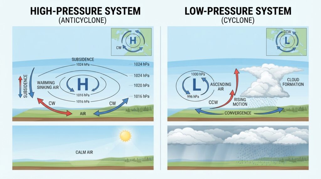
Surface winds spiral inward toward the low pressure center. The Coriolis effect deflects this inflow counterclockwise in the Northern Hemisphere and clockwise in the Southern Hemisphere—the opposite rotation from high pressure systems. The tight pressure gradient near an intense low can accelerate winds dramatically, producing gales or even hurricane-force conditions.
Low pressure systems are generally more dynamic and faster-moving than their high pressure counterparts. They draw energy from temperature contrasts and moisture content, which is why they intensify most readily over warm ocean surfaces and along sharp temperature boundaries known as fronts.
Extratropical cyclones—the mid-latitude low pressure systems familiar to residents of Europe, North America, and southern Australia—form along polar fronts where cold polar air meets warmer subtropical air. Tropical cyclones, including hurricanes and typhoons, derive their energy almost entirely from warm ocean water, sustaining themselves through a continuous cycle of evaporation and condensation.
The Role of Fronts in Pressure System Dynamics
Fronts are the boundaries between contrasting air masses, and they are inseparable from the behavior of pressure systems. Four primary frontal types exist: cold fronts, warm fronts, occluded fronts, and stationary fronts. Each produces a distinct weather sequence that meteorologists use to forecast conditions with considerable accuracy.
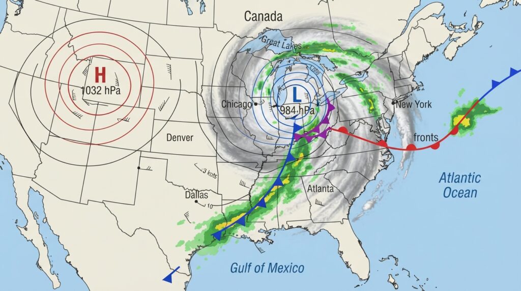
A cold front marks the leading edge of advancing cold air. As cold, dense air pushes under warmer air ahead of it, the warm air is forced to rise rapidly. This sharp uplift produces cumulonimbus clouds, heavy rainfall, thunderstorms, and a sudden drop in temperature following the front’s passage. Cold fronts move quickly and tend to bring the most dramatic short-term weather changes.
A warm front, by contrast, represents the leading edge of advancing warm air sliding over retreating cold air. The ascent is gentler and more gradual, producing a sequence of cloud types—from high cirrus to lower stratus—followed by prolonged, steady rain or drizzle. Warm fronts generally move more slowly than cold fronts and precede a milder, more humid air mass.
When a cold front catches up to a warm front—a common occurrence in the lifecycle of mid-latitude cyclones—an occluded front forms. The resulting weather can be complex, combining elements of both cold and warm frontal precipitation. Stationary fronts, as their name implies, stall between contrasting air masses and can bring persistent precipitation over a fixed area for extended periods.
The Interaction Between High and Low Pressure Systems
High and low pressure systems do not exist in isolation. Their interactions are continuous, dynamic, and responsible for the majority of significant weather events that affect human populations.
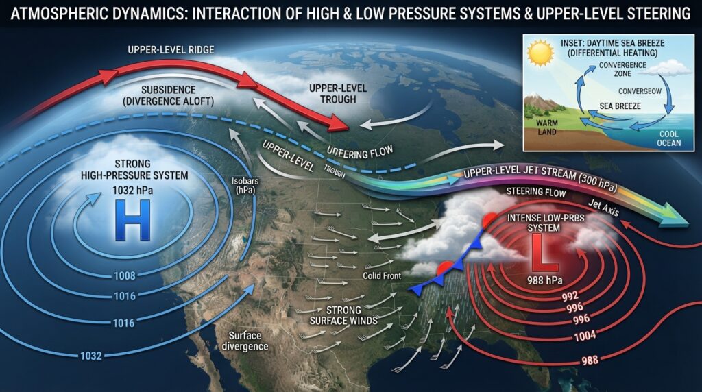
Pressure gradients between adjacent systems drive wind flow at the surface. When a strong high pressure system sits adjacent to an intense low, the pressure difference between them can generate powerful winds. This pairing is a common precursor to severe weather events, including nor’easters along the US East Coast, where cold Canadian highs interact with deepening Atlantic lows.
The jet stream—a band of fast-moving air at upper atmospheric levels—plays a crucial mediating role in these interactions. The jet stream steers surface pressure systems, guiding their tracks and influencing their intensity. Ridges of high pressure in the upper atmosphere slow or block the eastward progression of weather systems, creating what meteorologists call blocking patterns. These blocks can cause persistent weather anomalies, trapping a low pressure system over one region while another bakes under a stagnant high.
Thermal contrasts between land and sea also modulate how high and low pressure systems interact. Sea breezes develop when daytime heating creates a thermal low over land and a relative high over cooler water, drawing air onshore. At night, the pattern reverses as land cools faster than the ocean. On a larger scale, monsoon systems operate through the same principle—seasonal shifts in pressure driven by the differential heating of continents and oceans.
Regional and Seasonal Pressure Patterns
Earth’s pressure distribution is not random. Semi-permanent pressure systems anchor themselves to specific geographic locations and shift modestly with the seasons, shaping the climate of entire regions.
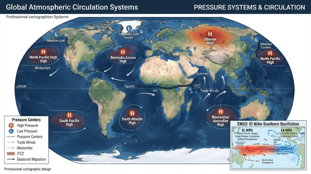
The Bermuda-Azores High, a subtropical anticyclone positioned over the North Atlantic, steers tropical storms toward the US East Coast during summer and autumn while suppressing rainfall across parts of Europe. The Siberian High, an intense cold-season anticyclone that builds over central Asia each winter, drives frigid air outbreaks across East Asia and influences precipitation patterns as far afield as the Indian subcontinent.
The Intertropical Convergence Zone (ITCZ) is a belt of low pressure near the equator where trade winds from the Northern and Southern Hemispheres converge. Its seasonal migration north and south follows the Sun’s position, triggering wet and dry seasons across tropical regions from West Africa to Southeast Asia.
El Niño–Southern Oscillation (ENSO), one of the most studied climate phenomena on Earth, involves large-scale shifts in sea surface temperatures and atmospheric pressure across the tropical Pacific. During El Niño events, weakened trade winds and warmer Pacific waters alter pressure patterns globally, shifting storm tracks, intensifying droughts in some regions, and producing flooding in others.
Forecasting and the Practical Significance of Pressure Systems
Modern weather forecasting depends heavily on tracking the development and movement of pressure systems. Numerical weather prediction models, which solve millions of mathematical equations representing atmospheric physics, simulate how pressure gradients, temperature fields, and moisture interact over time. Improvements in computing power and observational data—drawn from satellites, weather balloons, ocean buoys, and ground stations—have made five-day forecasts nearly as accurate as two-day forecasts were just three decades ago.
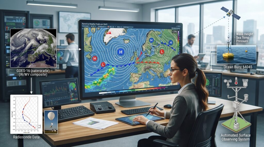
For the general public, understanding pressure systems transforms the ability to interpret weather maps and forecasts. Recognizing that a falling barometer signals the approach of a low pressure system—and the unsettled weather it carries—provides actionable information, whether one is planning a hiking trip or preparing for a potential storm. A rising barometer, conversely, indicates improving conditions as high pressure rebuilds.
The Broader Significance of Pressure System Science
The study of high and low pressure systems sits at the intersection of physics, chemistry, geography, and environmental science. These systems distribute heat and moisture around the planet, moderate temperature extremes, and sustain the precipitation cycles that all terrestrial life depends upon. As global temperatures rise due to anthropogenic climate change, the behavior of pressure systems is shifting in measurable ways—altering storm intensities, shifting rainfall patterns, and lengthening the persistence of blocking events that drive extreme heat and drought.
Understanding how high and low pressure systems form and interact is therefore not simply a matter of academic curiosity. It is foundational knowledge for anyone seeking to understand the atmosphere’s behavior, anticipate weather hazards, or grasp the mechanisms behind a changing climate. The sky, in all its complexity, follows rules—and atmospheric pressure lies at the heart of them.