

A weather front is a boundary between two air masses with different temperatures, humidity levels, and densities. The four main types—cold, warm, occluded, and stationary—each produce distinct weather patterns. Understanding these fronts explains much of the day-to-day weather variability experienced across mid-latitude regions.
Weather is rarely random. The sudden drop in temperature on an otherwise warm afternoon, the persistent drizzle that lingers for days, or the violent thunderstorms that roll in without much warning—all of these phenomena can be traced back to a single atmospheric concept: the weather front.
Fronts are the boundaries where the atmosphere’s great air masses collide, and understanding them is fundamental to meteorology. For students, science enthusiasts, and anyone curious about why the sky behaves the way it does, a clear explanation of frontal systems offers a window into the mechanics of our planet’s climate engine.
This article covers each of the four major front types in detail—how they form, what distinguishes them, and what weather conditions they produce. It also examines how these systems interact and why they matter for both daily forecasting and long-term climate patterns.
The Concept of Air Masses and Frontal Boundaries
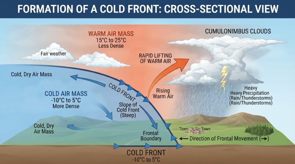
Before diving into individual front types, it helps to understand what an air mass actually is. An air mass is a large volume of air—often spanning hundreds or thousands of kilometers—that has acquired uniform temperature and humidity characteristics from the surface below it. When an air mass sits over a cold polar ocean for days or weeks, it becomes cold and dry. When it stews over a warm tropical sea, it becomes warm and moist.
The planet’s atmosphere is constantly moving these air masses around, driven by pressure gradients, the Coriolis effect from Earth’s rotation, and the uneven heating of the surface. When two air masses with different properties meet, they do not simply mix together. Instead, they form a boundary—a front—where the contrasting characteristics clash and produce distinctive weather.
The four recognized types of weather fronts are cold fronts, warm fronts, occluded fronts, and stationary fronts. Each is classified by the direction of movement and the temperature relationship between the advancing and retreating air masses.
Cold Fronts: Rapid and Dramatic Atmospheric Changes
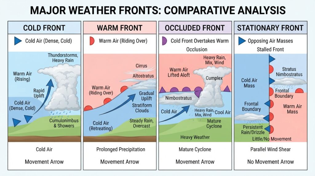
A cold front forms when a mass of cold, dense air advances and displaces warmer, lighter air ahead of it. Because cold air is denser than warm air, it moves along the surface like a wedge, forcing the warmer air steeply upward. This rapid lifting is the defining characteristic of a cold front—and the source of its dramatic weather.
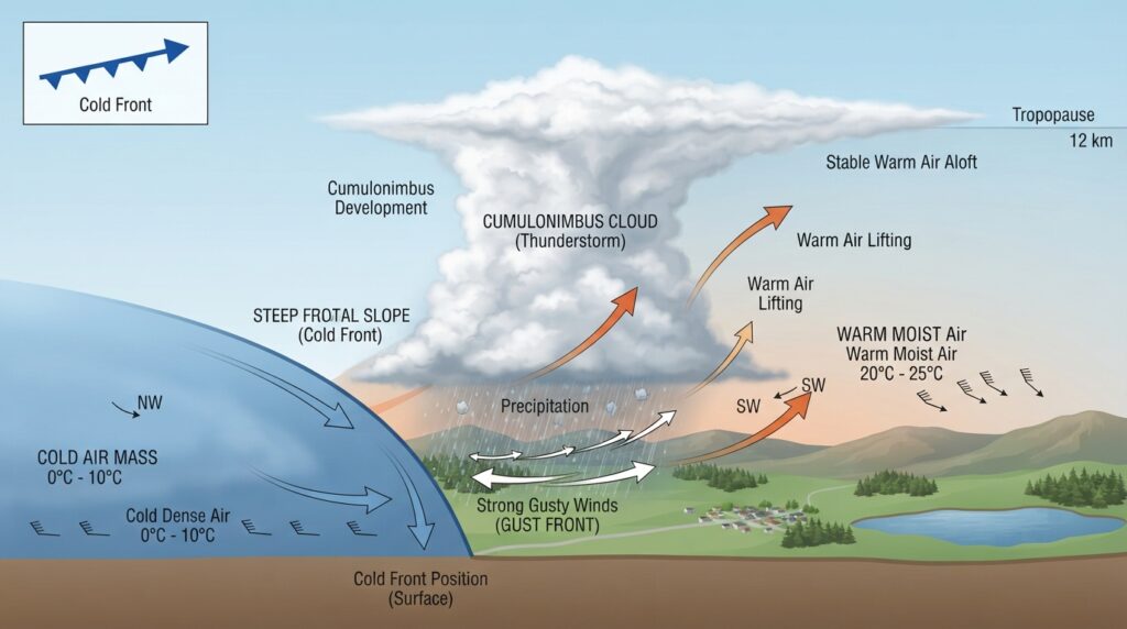
The steep slope of a cold front triggers fast, intense convection. Moisture in the rapidly rising warm air condenses quickly, forming towering cumulonimbus clouds capable of producing heavy rain, hail, strong gusty winds, and even tornadoes in extreme cases. These conditions tend to develop suddenly and pass through relatively quickly, typically within a matter of hours.
On a weather map, a cold front is represented by a solid blue line with triangular points (called pips) that indicate the direction of movement. In the Northern Hemisphere, cold fronts most often move from northwest to southeast, driven by the prevailing westerly winds.
After a cold front passes, conditions change sharply. Temperatures drop, sometimes by 10°C or more within an hour. Pressure rises, winds shift direction—often from southwesterly to northwesterly—and skies clear as the cold air mass settles in. The contrast between pre-frontal and post-frontal conditions is one of the most recognizable patterns in mid-latitude weather.
Warm Fronts: Gradual Transitions and Prolonged Precipitation
A warm front develops when a warm air mass advances and gradually overrides cooler air that is retreating ahead of it. Unlike the steep angle of a cold front, the slope of a warm front is gentle—typically around 1:150 to 1:200. This means the warm air rises slowly over a very long distance, sometimes extending hundreds of kilometers ahead of the surface front location.
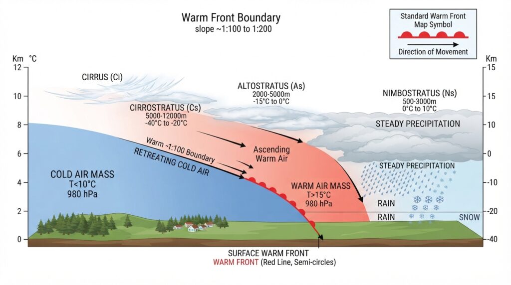
The gradual ascent of warm, moist air over the cool surface air produces a distinctive sequence of cloud types as the front approaches. High cirrus clouds appear first, often a day or more before the surface front arrives. These give way to cirrostratus, then altostratus, and finally the thick nimbostratus layer that brings steady, prolonged rain or snow. Fog is also common ahead of and at the surface front, particularly in cool seasons.
On a weather map, a warm front is drawn as a solid red line with semicircular bumps pointing in the direction of movement. The weather associated with a warm front is generally less violent than that of a cold front, but it is more persistent. Precipitation can last for 12 to 24 hours or longer, making warm fronts significant contributors to regional rainfall totals.
Once the warm front passes, temperatures rise noticeably, humidity increases, winds veer (typically from southeasterly to southwesterly in the Northern Hemisphere), and pressure stabilizes. The region behind the warm front and ahead of the following cold front is called the warm sector—a zone of relatively warm, moist, and often hazy air.
Occluded Fronts: The Mature Stage of a Frontal System
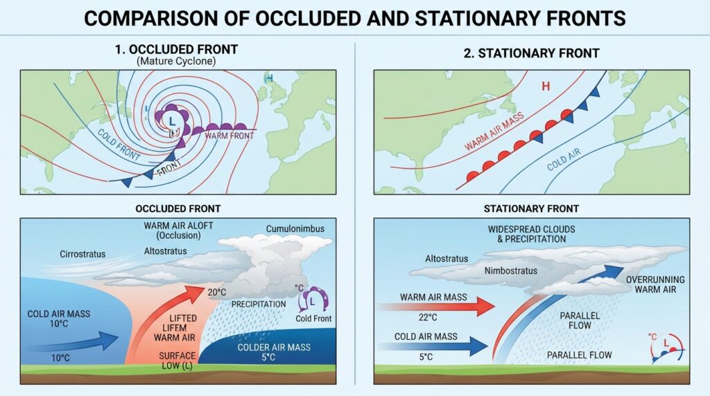
An occluded front is the product of a frontal system reaching its mature stage. In a typical mid-latitude cyclone, a cold front and a warm front extend from a central low-pressure area. Cold fronts move faster than warm fronts. Over time, the cold front catches up to the warm front, lifting the warm sector off the ground entirely. This process is called occlusion.
Two types of occluded fronts exist, depending on the relative temperatures of the air masses involved. A cold occlusion occurs when the air behind the cold front is colder than the air ahead of the retreating warm front. In this case, the cold front undercuts both the warm air and the cool air ahead of the warm front, lifting everything upward. A warm occlusion occurs when the air behind the cold front is less cold than the air ahead of the warm front, causing it to override the cooler surface air rather than undercut it.
Occluded fronts are represented on weather maps by a purple line with alternating triangular and semicircular pips. The weather they produce is a blend of both cold and warm frontal characteristics—prolonged cloud cover, moderate to heavy precipitation, and gradually changing temperatures. Because they form at the peak of a cyclone’s lifecycle, occluded fronts are often associated with the most intense and widespread precipitation events in a given system.
As the occlusion process progresses, the low-pressure center begins to weaken and fill. The frontal system gradually dissipates, and the associated weather becomes less organized. Understanding occlusion helps meteorologists track the lifecycle and predict the eventual decay of storm systems.
Stationary Fronts: Persistent Boundaries and Regional Weather Patterns
A stationary front forms when two contrasting air masses meet but neither has sufficient momentum to displace the other. The boundary essentially stalls in place, sometimes persisting for days at a time. During this period, the front may oscillate slightly north and south, but it maintains its general position.
The weather produced by a stationary front depends largely on which side of the boundary a given location sits on. The warm, moist air slowly rises over the cooler air along the entire length of the front, generating persistent cloud cover and prolonged light to moderate precipitation. Regions near a stationary front can experience days of continuous rain or drizzle, making these systems significant contributors to flooding events, particularly when slow-moving weather patterns block the front from progressing.
On weather maps, a stationary front appears as alternating red semicircular bumps and blue triangular pips, each pointing in the opposite direction to reflect the lack of dominant movement. The opposing symbols represent the two air masses pushing against each other with roughly equal force.
Stationary fronts can eventually be set in motion if one air mass gains energy. A stationary front that begins moving becomes either a cold front or a warm front, depending on which air mass ultimately advances. In some cases, however, they simply dissipate as the air masses gradually mix and lose their contrasting characteristics.
Frontal Systems and Mid-Latitude Weather Patterns
The four front types do not exist in isolation—they are components of larger weather systems that shape the climate of mid-latitude regions, including much of the United States, Europe, and East Asia. The mid-latitude cyclone model, also known as the Norwegian cyclone model (developed by meteorologists at the Bergen School in Norway in the early 20th century), describes how cold and warm fronts develop together around a central low-pressure system.
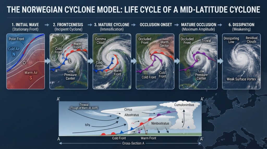
In this model, a wave of instability along the polar front—the boundary between cold polar air and warmer mid-latitude air—triggers the development of a low-pressure center. Cold air wraps around the back of the low while warm air advances ahead of it, creating the characteristic comma-shaped cloud pattern visible in satellite imagery. As the system matures, occlusion occurs and the storm eventually weakens.
This cyclone lifecycle repeats dozens of times each year across the mid-latitudes, driving the week-to-week variability in temperature, precipitation, and wind that residents of these regions experience throughout the year. Modern weather forecasting relies heavily on tracking these frontal systems using satellite data, weather balloons, surface observations, and numerical weather prediction models.
The Practical Importance of Understanding Weather Fronts
Weather fronts have direct consequences for agriculture, transportation, public safety, and water resource management. Farmers depend on accurate frontal forecasts to time planting and harvesting. Aviation authorities monitor fronts to avoid turbulence and icing conditions. Emergency managers use frontal forecasts to prepare for flooding, severe storms, and temperature extremes.
For the general public, awareness of frontal systems transforms weather forecasting from a guessing game into an interpretable pattern. Knowing that a cold front is approaching means expecting sharp clearing and temperature drops after a period of storms. Seeing a warm front on the forecast map signals days of gradual warming preceded by persistent cloud and rain. Recognizing a stationary front explains why the same soggy weather has been stuck in place all week.
The Atmospheric Boundaries That Shape Our Weather
Weather fronts are among the most consequential and well-understood phenomena in atmospheric science. Cold fronts bring intensity and rapid change. Warm fronts bring gradual transitions and sustained precipitation. Occluded fronts mark the climactic stage of a storm system’s life. Stationary fronts bring persistence and patience-testing drizzle.
Together, these four frontal types account for a significant portion of the weather variability that defines life in the mid-latitudes. Meteorologists have studied fronts for over a century, and while forecast models have grown extraordinarily sophisticated, the fundamental principles of frontal analysis remain central to how weather is understood and communicated today.
The next time the forecast calls for a frontal passage, you’ll know exactly what to expect—and why.