

El Niño–Southern Oscillation, commonly known as ENSO, is one of the most powerful and far-reaching climate phenomena on Earth. Originating in the tropical Pacific Ocean, ENSO influences weather patterns across virtually every continent, triggering droughts in some regions, flooding in others, and reshaping agricultural output, water availability, and disaster risk on a global scale.
Understanding ENSO is no longer the exclusive domain of climatologists and oceanographers. Policymakers, farmers, insurers, urban planners, and public health officials all rely on ENSO forecasts to make critical decisions—months in advance. As climate change continues to alter the frequency and intensity of ENSO events, the need for public literacy on this topic has never been greater.
This article provides a comprehensive overview of ENSO: what it is, how it works, what its phases mean for the planet, and how scientists track and predict it.
The Science Behind ENSO
ENSO describes a recurring cycle of ocean temperature and atmospheric pressure changes in the central and eastern tropical Pacific Ocean. The phenomenon has two primary components that operate in tandem: the oceanic component (El Niño and La Niña) and the atmospheric component (the Southern Oscillation).
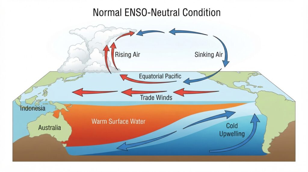
Under normal conditions, trade winds blow westward along the equator, pushing warm surface water toward the Indo-Pacific region and causing cooler, nutrient-rich water to upwell along the South American coast. This baseline state supports distinct regional climates—wet conditions in Southeast Asia and Australia, dry conditions along the west coast of South America.
ENSO disrupts this equilibrium. When the system shifts significantly enough in either direction, the result is a measurable, sustained departure from normal climate conditions across a vast portion of the globe.
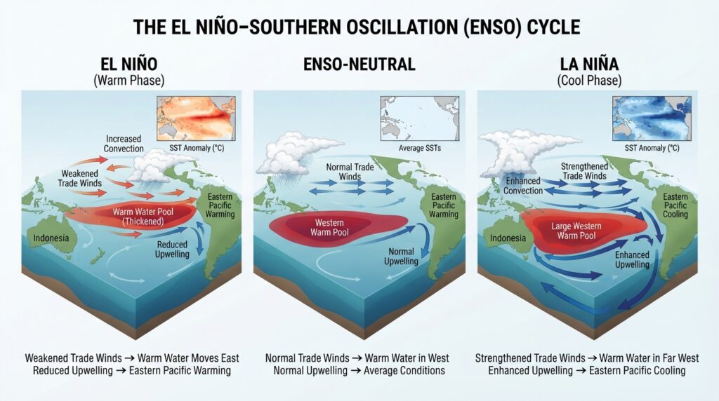
The Three Phases of ENSO
El Niño: The Warm Phase
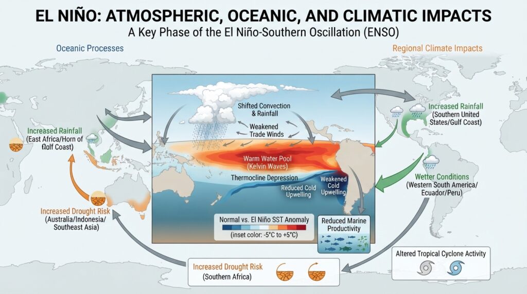
El Niño occurs when sea surface temperatures (SSTs) in the central and eastern tropical Pacific warm by at least 0.5°C above the long-term average for a sustained period—typically five overlapping three-month periods, as defined by NOAA’s Oceanic Niño Index (ONI). During El Niño events, the trade winds weaken or even reverse, allowing warm water to slosh eastward across the Pacific.
The consequences are widespread. Rainfall patterns shift dramatically: parts of South America, the southern United States, and East Africa receive above-average precipitation, while Australia, Southeast Asia, and southern Africa often experience severe drought. The 1997–1998 El Niño event—widely regarded as one of the strongest on record—caused an estimated $45 billion in damages and was linked to approximately 23,000 deaths worldwide, according to data reviewed by NOAA.
El Niño also suppresses Atlantic hurricane activity while increasing the frequency and intensity of storms in the central and eastern Pacific. Ocean ecosystems along the South American coast suffer when the upwelling of cold, nutrient-rich water diminishes, devastating fish populations and the industries that depend on them.
La Niña: The Cool Phase
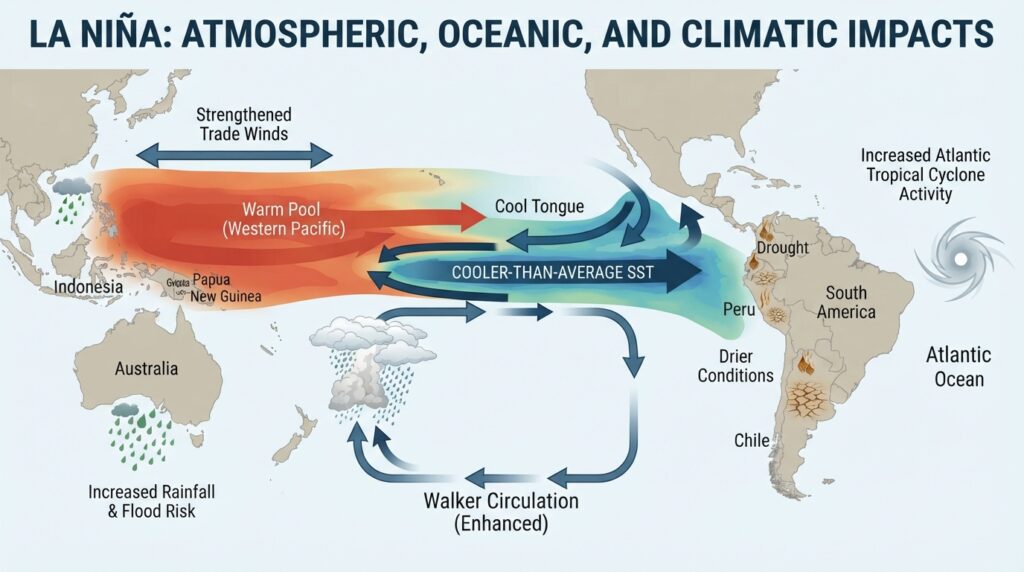
La Niña is the counterpart to El Niño. It occurs when SSTs in the central and eastern tropical Pacific fall at least 0.5°C below average. Trade winds intensify during La Niña, pushing warm water further westward and enhancing the upwelling of cold water off South America.
The climatic effects of La Niña are broadly opposite to those of El Niño. Australia and Southeast Asia tend to experience above-normal rainfall and an elevated risk of flooding. East Africa and parts of South America face drier conditions. The Atlantic hurricane season typically becomes more active during La Niña years, as reduced wind shear allows storms to develop and intensify more readily.
The 2010–2011 La Niña was among the strongest in decades and contributed to catastrophic flooding in Queensland, Australia, severe drought in the Horn of Africa, and record-breaking rainfall across Colombia and Pakistan.
ENSO-Neutral: The Baseline State
Between El Niño and La Niña episodes, the tropical Pacific often returns to a neutral state in which SSTs are close to average and trade winds maintain their typical strength and direction. ENSO-neutral periods can last months or even years, and while they lack the dramatic regional impacts of the active phases, they represent the baseline from which future departures are measured.
The Southern Oscillation: The Atmospheric Dimension
The term “Southern Oscillation” refers to the atmospheric pressure seesaw between the eastern and western tropical Pacific. This pressure difference is quantified by the Southern Oscillation Index (SOI), which measures the standardized difference in air pressure between Tahiti (representing the eastern Pacific) and Darwin, Australia (representing the western Pacific).
During El Niño events, atmospheric pressure rises over Australia and the western Pacific while falling over the eastern Pacific—producing a negative SOI. La Niña produces the opposite pattern: lower pressure over Australia and a positive SOI. The coupling between SST anomalies and this atmospheric pressure pattern is what makes ENSO a self-reinforcing feedback system, at least in its early stages.
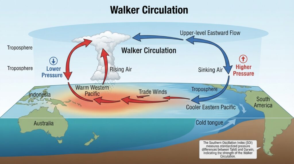
The discovery of this connection between oceanic and atmospheric variables is largely credited to Sir Gilbert Walker, a British mathematician who analyzed surface pressure data in the early 20th century. Decades later, meteorologist Jacob Bjerknes demonstrated that the Walker Circulation—the large-scale loop of rising air over the warm western Pacific and sinking air over the cooler east—was intricately linked to SST variations. This insight laid the groundwork for modern ENSO science.
Global Teleconnections and Regional Impacts
One of the most scientifically significant aspects of ENSO is its ability to affect climate conditions thousands of kilometers from the tropical Pacific through atmospheric pathways called teleconnections. These are statistical relationships between weather patterns in distant regions, mediated by shifts in large-scale atmospheric circulation.
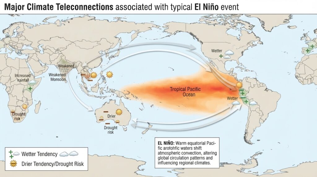
In North America, El Niño winters tend to bring wetter and cooler conditions to the southern United States and milder temperatures to the northern states and Canada. In India, El Niño events have been historically associated with weakened summer monsoons, posing risks to agricultural production across the subcontinent. Sub-Saharan Africa experiences reduced rainfall during El Niño, increasing food insecurity in already vulnerable communities.
The breadth of ENSO’s influence means that its impacts rarely occur in isolation. Regional food production, hydroelectric power generation, disease transmission rates (particularly for malaria and cholera), and water resource management are all shaped, to varying degrees, by the state of ENSO in any given season.
ENSO Monitoring and Prediction
Modern ENSO forecasting relies on an integrated network of observational systems. The Tropical Atmosphere Ocean (TAO) array—now known as the TAO/TRITON array—consists of approximately 70 moored ocean buoys stretching across the tropical Pacific, continuously measuring ocean temperatures, winds, and currents at various depths. Satellite-based instruments complement this data by tracking SSTs, sea surface height, and outgoing longwave radiation from space.
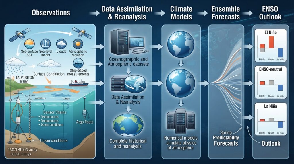
Numerical climate models—both statistical and dynamical—are used to translate this observational data into ENSO forecasts. NOAA’s Climate Prediction Center (CPC), the International Research Institute for Climate and Society (IRI), and the European Centre for Medium-Range Weather Forecasts (ECMWF) all issue regular ENSO outlooks that extend several months into the future.
Forecast skill is highest during boreal spring, when ENSO tends to develop or intensify. However, the so-called “spring predictability barrier” makes it difficult to reliably predict ENSO state beyond six to nine months in advance. Despite this limitation, even seasonal forecasts offer enormous value to agricultural planners, humanitarian organizations, and disaster preparedness agencies.
ENSO and Climate Change: An Evolving Relationship
The relationship between ENSO and long-term climate change is an area of active research and ongoing scientific debate. Global warming is altering the baseline conditions of the tropical Pacific, raising average SSTs and potentially modifying the frequency, duration, and intensity of ENSO events.
Several studies published in peer-reviewed journals—including research appearing in Nature Climate Change and Geophysical Research Letters—suggest that extreme El Niño events may become more frequent as the planet warms. The physical reasoning centers on the idea that a warmer mean state amplifies the SST contrasts that trigger strong El Niño episodes. However, model projections vary significantly, and uncertainty remains substantial.
What is more broadly accepted is that the impacts of any given ENSO event will be amplified in a warmer world. Stronger background warming means that the additional heat brought by El Niño will push temperatures even further above historical thresholds. Heavier background precipitation means that La Niña flooding events may become more severe. In this sense, ENSO does not operate in isolation from the broader trajectory of climate change—the two systems interact in ways that compound risk for communities already dealing with the consequences of a changing climate.
The Broader Significance of ENSO Research
ENSO research sits at the intersection of oceanography, atmospheric science, ecology, economics, and public health. Its significance extends well beyond academic inquiry. Governments in ENSO-sensitive regions use forecast information to pre-position food aid, adjust planting calendars, manage reservoir levels, and coordinate disaster response. International organizations such as the World Meteorological Organization (WMO) and the Food and Agriculture Organization (FAO) actively integrate ENSO outlooks into humanitarian planning cycles.
The economic stakes are substantial. A 2021 analysis published in Science estimated that a single strong El Niño event can reduce global GDP by trillions of dollars over the following years, with the heaviest losses concentrated in tropical countries least equipped to absorb the shock. Improved seasonal forecasting, therefore, delivers measurable economic and humanitarian value—making continued investment in ENSO monitoring and research a matter of practical necessity, not just scientific curiosity.
The Ongoing Importance of ENSO Literacy
ENSO is not a distant abstraction confined to scientific journals or government climate bulletins. Its fingerprints appear in harvest yields, flood insurance premiums, malaria outbreak patterns, and the cost of electricity in countries that rely on hydropower. Awareness of ENSO—how it forms, how it evolves, and what it means for specific regions—equips communities, governments, and institutions to respond more effectively to one of nature’s most consequential cycles.
As climate science continues to advance and observational networks grow more sophisticated, ENSO forecasting will only improve. But the value of that improved knowledge depends entirely on how well it is understood, communicated, and applied by the people and organizations who stand to benefit most from it.