

Blocking highs are persistent high-pressure systems that disrupt normal atmospheric flow, causing prolonged weather extremes. Omega patterns are a specific type of blocking configuration shaped like the Greek letter Ω. Both phenomena can last days to weeks, triggering heatwaves, floods, and droughts across large regions.
Few atmospheric phenomena carry as much meteorological weight as blocking highs and omega patterns. While most weather systems drift predictably across the globe, these large-scale pressure structures can grind normal circulation to a halt—sometimes for weeks at a time—with consequences that range from record-breaking heatwaves to devastating floods.
Understanding these patterns matters well beyond the academic. The 2021 Pacific Northwest heat dome, which pushed temperatures in Portland, Oregon to 116°F (46.7°C), was driven by an exceptionally strong blocking high. The 2002 European floods, which caused billions in damage across Central Europe, were similarly tied to a persistent blocking configuration. As climate change reshapes atmospheric dynamics, blocking events are attracting increased attention from researchers and forecasters alike.
This article provides a thorough examination of blocking highs and omega patterns—what they are, how they form, how meteorologists identify them, and why they matter for both weather forecasting and climate science.
The Fundamentals of Atmospheric Blocking
The term “blocking” refers to the interruption of the prevailing westerly winds in the mid-latitudes. Under normal conditions, the jet stream guides weather systems from west to east across the Northern and Southern hemispheres. Blocking occurs when a large, quasi-stationary high-pressure system becomes entrenched in the jet stream’s path, deflecting it around the obstacle rather than through it.

This disruption is not subtle. A blocking high can redirect the jet stream significantly northward or southward, channeling cold Arctic air deep into the mid-latitudes on one side while trapping warm air on the other. The result is a pronounced and prolonged departure from typical weather conditions across a broad geographic area.
Blocking events are defined by their persistence. Meteorologists generally classify a high-pressure system as a blocking high when it remains stationary or nearly stationary for at least five days—though many blocking events last two to four weeks. This longevity is what separates blocking patterns from ordinary high-pressure ridges, which tend to drift eastward with the prevailing flow.
The Physical Mechanisms Behind Blocking High Formation
The exact mechanisms driving blocking high formation remain an active area of research, but several contributing factors are well established.
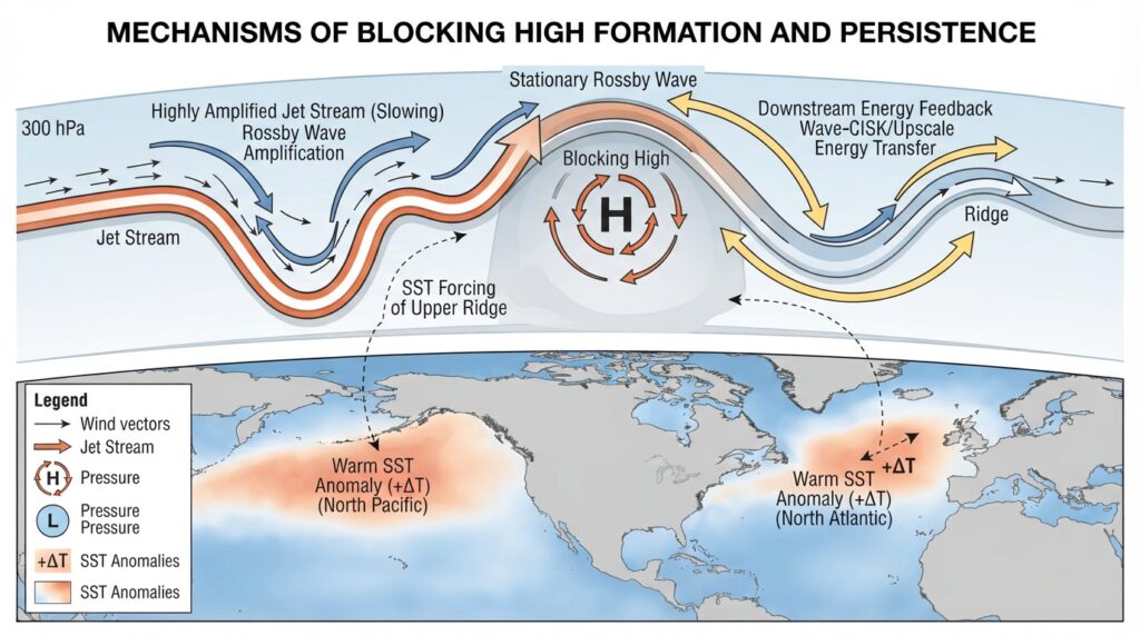
Large-scale Rossby wave amplification plays a central role. Rossby waves are slow-moving, planetary-scale waves embedded in the upper atmosphere. When these waves amplify—often in response to thermal contrasts between land and ocean, or between polar and tropical air masses—they can develop pronounced ridges of high pressure. If the wave’s phase speed slows sufficiently, the ridge can become stationary, marking the onset of a blocking event.
Energy dispersion from downstream systems also contributes. Research published in journals such as the Journal of the Atmospheric Sciences has demonstrated that breaking Rossby waves downstream of an existing trough can feed energy back into an upstream ridge, reinforcing and sustaining it. This feedback mechanism helps explain why blocking events often persist long after the initial atmospheric impulse that triggered them.
Sea surface temperature anomalies in the Pacific and Atlantic oceans can precondition the atmosphere for blocking. Warmer-than-usual ocean temperatures increase the thermal contrast available to amplify Rossby waves, raising the likelihood of blocking development. This connection has made ocean temperature monitoring a valuable tool in extended-range forecasting.
The Omega Pattern: Structure and Identification
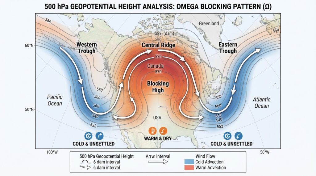
The omega blocking pattern is named for its striking resemblance to the Greek letter Ω when viewed on an upper-level weather map, typically at the 500 millibar pressure level.
In an omega configuration, a large ridge of high pressure is flanked on both sides by deep troughs of low pressure. The central ridge forms the peak of the Ω shape, while the two lateral troughs form the curved lower ends. This arrangement is not merely visually distinctive—it has important dynamical implications.
The central ridge of an omega pattern is typically an exceptionally robust high-pressure system. The flanking troughs act as anchors, limiting the ridge’s eastward progression and locking the entire configuration in place. Cold, unsettled weather tends to dominate the regions beneath the troughs, while the area under the ridge experiences warm, dry, and often cloudless conditions.
On a practical level, meteorologists identify omega patterns by examining contour maps of 500 millibar geopotential height. The Ω shape becomes apparent when the central ridge extends well poleward and the surrounding troughs dip significantly equatorward. Numerical weather prediction models—including the Global Forecast System (GFS) and the European Centre for Medium-Range Weather Forecasts (ECMWF) model—routinely highlight these configurations during forecast briefings.
Weather Impacts Associated with Blocking Highs and Omega Patterns
The weather consequences of atmospheric blocking are among the most severe that mid-latitude regions can experience, precisely because they are sustained over extended periods.
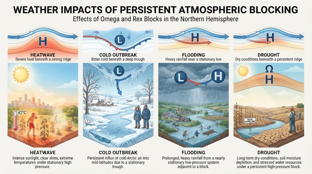
Heatwaves are the most commonly cited impact. Beneath the ridge of a blocking high, sinking air suppresses cloud formation and promotes intense surface warming. With little cloud cover to limit incoming solar radiation and no frontal systems to provide relief, temperatures can rise dramatically over days and weeks. The European heatwave of 2003, which caused an estimated 70,000 excess deaths across the continent according to the European Journal of Epidemiology (2008), was associated with a persistent summer blocking pattern over Western Europe.
Cold outbreaks occur in the regions beneath the flanking troughs of an omega pattern. As the jet stream dips far southward on either side of the central ridge, Arctic air can surge into temperate zones. North America, for example, has experienced several such events, including the polar vortex disruptions of recent winters, where blocking patterns allowed frigid air to plunge deep into the central and eastern United States.
Flooding results from slow-moving or stationary low-pressure systems trapped adjacent to a blocking high. When a trough associated with a blocking pattern becomes nearly stationary, the continuous influx of moisture-laden air into the same geographic region can produce days of persistent, heavy precipitation. The 2002 Elbe River floods in Germany and Central Europe, which caused damages exceeding €15 billion, occurred under precisely these conditions.
Drought is a longer-term consequence of prolonged blocking. Regions consistently under the influence of a blocking high receive little precipitation for weeks or months, depleting soil moisture and stressing water resources.
The Role of the Jet Stream in Sustaining Blocking Events
The relationship between blocking highs and the jet stream is bidirectional. The jet stream’s behavior influences whether blocking develops, and once established, a blocking high significantly alters the jet stream’s structure.
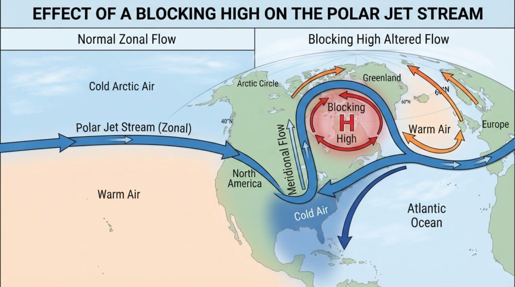
Under normal conditions, the polar jet stream in the Northern Hemisphere flows in a broadly zonal pattern—roughly west to east—with relatively modest north-south excursions. This zonal flow efficiently transports heat and moisture around the globe and drives the regular progression of weather systems.
When a blocking high establishes itself, the jet stream is forced into a strongly meridional (north-south) pattern. This has cascading effects: weather systems move more slowly, temperature contrasts between adjacent regions intensify, and the overall atmospheric circulation becomes less efficient at redistributing heat. Research by Jennifer Francis at Rutgers University (published in Geophysical Research Letters, 2012) suggested that reduced Arctic sea ice may be weakening the jet stream’s zonal flow, potentially increasing the frequency and persistence of blocking events—though this hypothesis remains debated within the scientific community.
Forecasting Challenges Presented by Blocking Patterns
Blocking events represent some of the most difficult scenarios for numerical weather prediction. Modern forecast models perform reasonably well for the first five to seven days, but accurately predicting the onset, intensity, and breakdown of blocking events at longer lead times remains a significant challenge.
Several factors contribute to this difficulty. Blocking patterns are sensitive to small errors in the initial atmospheric state—a slight misrepresentation of a trough upstream can lead to large forecast errors downstream. Additionally, the physical processes that sustain blocking, particularly the interactions between Rossby waves and synoptic-scale eddies, are not fully resolved in current operational models.
Ensemble forecasting has become an essential tool for communicating blocking-related uncertainty. Rather than issuing a single deterministic forecast, ensemble systems run dozens of model simulations with slightly varied initial conditions. When a large proportion of ensemble members agree on the development of a blocking pattern, forecasters gain confidence in the prediction. When members diverge significantly, that spread itself conveys important information about forecast uncertainty.
The ECMWF ensemble system, widely regarded as the world’s leading operational forecast model, has demonstrated measurable skill in detecting blocking onset at lead times of up to 10 days under favorable conditions. However, breakdown of blocking—the transition back to normal westerly flow—remains harder to predict, often with useful skill limited to three to five days.
Blocking Events and Climate Change
The intersection of atmospheric blocking and climate change is one of the most actively researched topics in contemporary meteorology and climatology.
As Arctic temperatures rise at roughly two to four times the global average rate—a process known as Arctic amplification—the thermal gradient between the equator and the poles weakens. This weakening is theorized to reduce the jet stream’s speed and increase its tendency to develop large-amplitude meanders, potentially creating more favorable conditions for blocking. However, the evidence is mixed. Some modeling studies support increased blocking frequency under future climate scenarios; others suggest little change or even a reduction in blocking over certain regions.
What is more clearly established is that the impacts of blocking events are intensifying. A blocking high that would have produced a heatwave in a pre-industrial climate now operates in an atmosphere that is roughly 1.2°C warmer globally, according to the Intergovernmental Panel on Climate Change (IPCC) Sixth Assessment Report (2021). This baseline warming amplifies the temperature anomalies associated with blocking events, pushing heat extremes to unprecedented levels with greater frequency.
The Broader Significance of Blocking in Atmospheric Science
Blocking highs and omega patterns represent more than isolated meteorological curiosities. They sit at the intersection of daily weather and long-term climate, connecting the behavior of the upper atmosphere to tangible impacts on agriculture, water resources, public health, and infrastructure.
For operational meteorologists, recognizing a developing blocking pattern is a signal to issue extended-range guidance with elevated confidence—and appropriate caveats. For climate scientists, blocking events serve as natural experiments in extreme weather dynamics, illuminating how the atmosphere responds to both internal variability and external forcing. For policymakers and emergency managers, the lesson is increasingly clear: the capacity for a single persistent pressure pattern to reshape weather across an entire continent demands serious attention in adaptation planning.
As observational networks improve, forecast models become more sophisticated, and understanding of the jet stream deepens, the science of atmospheric blocking will continue to advance. The atmosphere, however, will keep generating new surprises—and blocking highs will remain among its most dramatic and consequential expressions.