

An air mass is a large body of air with uniform temperature and humidity, shaped by the surface it forms over. Air masses are classified by source region—arctic, polar, tropical, or equatorial—and by moisture content. Their movement drives most of the world’s weather patterns, from cold snaps to tropical storms.
Few forces shape daily weather as powerfully as air masses. These vast bodies of air—stretching hundreds to thousands of kilometers across—carry the temperature, moisture, and pressure characteristics of the regions where they form. When they move, they carry those characteristics with them, colliding with contrasting air masses to produce fronts, storms, and dramatic shifts in weather.
Understanding air masses is fundamental to meteorology. It explains why a sudden cold snap can sweep across a continent in a matter of days, why coastal cities experience dense fog, and why the interior of large landmasses tends toward weather extremes. For students, weather enthusiasts, and anyone curious about what drives the atmosphere, air masses provide one of the clearest frameworks for understanding how weather actually works.
This article covers the essential science of air masses—how they form, how they are classified, how they move, and how their interactions shape the weather patterns that affect billions of people every day.
The Formation of Air Masses
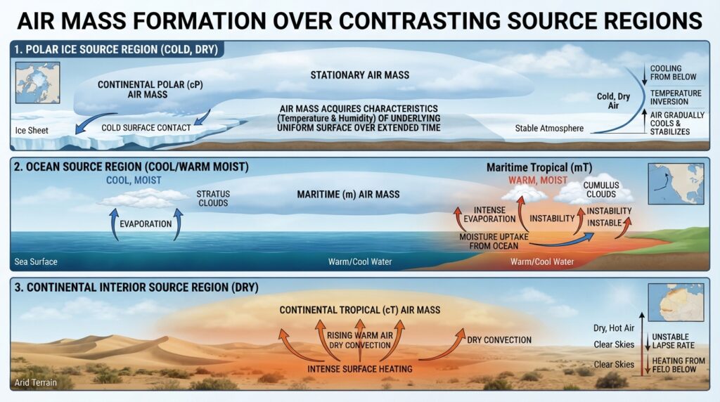
An air mass forms when a large body of air remains stationary—or moves very slowly—over a uniform surface for an extended period. This period of stagnation allows the air to gradually acquire the temperature and moisture characteristics of the surface beneath it. The region where this occurs is called the source region.
For a location to function effectively as a source region, it must meet two conditions. First, it must be sufficiently uniform in surface type—whether that is open ocean, polar ice, or tropical forest. Second, the atmosphere above it must be relatively stable, allowing the lower layers of air to absorb surface properties without excessive vertical mixing disrupting the process.
The most productive source regions on Earth are found at the poles, over large subtropical ocean basins, and across the broad interiors of continents. Each produces air masses with distinct characteristics that remain identifiable long after the air has moved away from its origin point.
The Classification of Air Masses
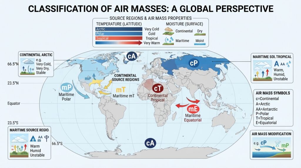
Meteorologists classify air masses using a two-part system based on latitude (which determines temperature) and surface type (which determines moisture content).
Classification by Latitude
Arctic (A) and Antarctic (AA) air masses form over the polar ice caps. These are the coldest air masses on Earth, characterized by extremely low temperatures and very low moisture content due to the cold, dry conditions of their source regions.
Polar (P) air masses originate at higher latitudes—roughly between 50° and 60° North or South—over both continental interiors and ocean surfaces. They are cold but less extreme than arctic air masses, and they play a central role in the weather of mid-latitude regions.
Tropical (T) air masses develop over subtropical regions, generally between 20° and 35° latitude. These air masses are warm to hot, and their moisture content varies depending on whether they form over land or ocean.
Equatorial (E) air masses form near the equator and are consistently warm and moist. They are closely associated with the Intertropical Convergence Zone (ITCZ) and contribute significantly to tropical rainfall patterns.
Classification by Surface Type
Continental (c) air masses form over land. Because land surfaces do not retain moisture the way oceans do, continental air masses tend to be drier than their maritime counterparts.
Maritime (m) air masses develop over large bodies of water and absorb substantial moisture as they form. These air masses are typically more humid and, because ocean temperatures change slowly, they also tend to be more moderate in temperature.
Combining these two sets of descriptors produces the standard classification system used in meteorology:
- cA – Continental Arctic: Extremely cold and dry
- cP – Continental Polar: Cold and dry
- cT – Continental Tropical: Hot and dry
- mP – Maritime Polar: Cold and moist
- mT – Maritime Tropical: Warm and moist
- mE – Maritime Equatorial: Hot and very moist
Each of these types produces predictable weather conditions when it moves over populated areas.
The Major Air Mass Types and Their Weather Characteristics
Continental Arctic and Continental Polar Air Masses
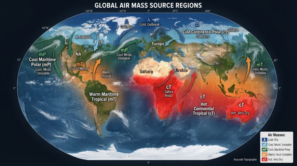
Continental arctic (cA) and continental polar (cP) air masses are the primary drivers of cold weather outbreaks across the Northern Hemisphere. During winter, these air masses build over Siberia, northern Canada, and the Arctic basin, accumulating extremely low temperatures over weeks of radiative cooling.
When the polar vortex weakens—a phenomenon that has received increasing attention in recent decades—these air masses can push far southward, producing dangerous wind chills across the central United States, Eastern Europe, and northern Asia. Continental polar air masses are responsible for the classic “Alberta Clippers” that sweep across North America, bringing sharp temperature drops and light snow.
Because these air masses originate over cold, dry land, they carry little moisture. The snowfall they produce is typically light and powdery rather than heavy and wet.
Maritime Polar Air Masses
Maritime polar (mP) air masses form over the cold northern and southern ocean basins—the North Pacific, North Atlantic, and the seas around Antarctica. Unlike their continental counterparts, they arrive laden with moisture absorbed from the ocean surface.
On the west coasts of continents, mP air masses are responsible for persistent cloud cover, drizzle, and moderate temperatures. The Pacific Northwest of North America, the British Isles, and coastal Norway all experience weather dominated by maritime polar air. When these moist air masses are forced to rise over coastal mountain ranges—a process called orographic lifting—they can deliver exceptionally heavy precipitation on windward slopes.
Maritime Tropical Air Masses
Maritime tropical (mT) air masses are among the most weather-active on Earth. Forming over warm subtropical ocean waters—the Gulf of Mexico, the Caribbean Sea, and the western Pacific—they carry warm, moisture-rich air that fuels some of the most intense weather systems known.
In North America, maritime tropical air from the Gulf of Mexico flows northward across the Great Plains, where it frequently encounters cold, dry continental polar air. The boundary between these two contrasting air masses is one of the most storm-prone zones on the planet, generating the severe thunderstorms and tornadoes for which Tornado Alley is well known.
Maritime tropical air masses also play a critical role in the development of tropical cyclones. When sea surface temperatures exceed approximately 26.5°C (79.7°F), mT air masses gain sufficient energy and moisture to support hurricane formation, as documented by the National Oceanic and Atmospheric Administration (NOAA).
Continental Tropical Air Masses
Continental tropical (cT) air masses develop over hot, arid land surfaces such as the Sahara Desert, the Arabian Peninsula, and the interior of Australia during summer. These are the driest and hottest of the major air mass types.
When cT air moves into adjacent regions, it brings heat waves and drought conditions. The Saharan air layer—a warm, dusty layer that frequently crosses the Atlantic Ocean—is a well-documented example of continental tropical air influencing weather far from its source region. Research published by the American Meteorological Society has linked Saharan dust outbreaks to suppressed Atlantic hurricane activity, as the dry, stable air inhibits storm development.
The Movement of Air Masses
Air masses do not remain stationary indefinitely. Once the general circulation of the atmosphere sets them in motion, they travel away from their source regions, modifying both themselves and the areas they pass over.
The Role of Pressure Systems and Wind Belts
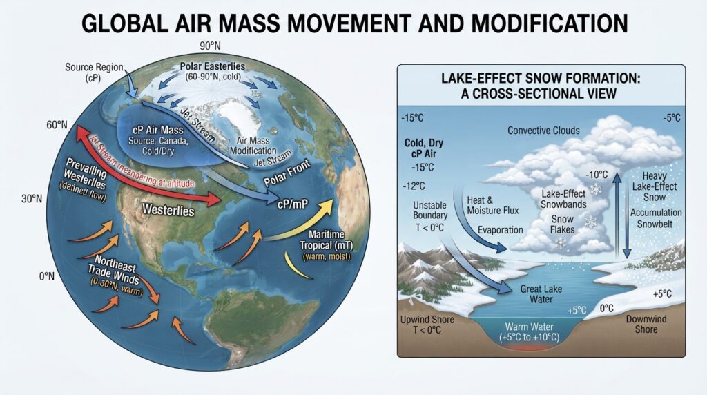
The primary driver of air mass movement is the global pressure gradient—the difference in atmospheric pressure between regions. Air flows from areas of high pressure toward areas of low pressure, and this flow is organized by the major wind belts of the Earth: the trade winds, the westerlies, and the polar easterlies.
In the mid-latitudes, the westerlies dominate. Most air masses affecting North America, Europe, and Asia travel broadly from west to east, steered by the jet stream—a narrow band of fast-moving air in the upper troposphere. The position and strength of the jet stream determine how far north or south air masses penetrate, and shifts in the jet stream are closely associated with prolonged spells of extreme weather.
Air Mass Modification
As an air mass travels across different surfaces, it undergoes modification. A cold, dry continental polar air mass moving over the Great Lakes in autumn, for example, absorbs moisture evaporated from the relatively warm lake surfaces. This process—known as lake-effect snow—can transform a relatively dry air mass into one capable of depositing several feet of snow on downwind shorelines.
Similarly, a maritime tropical air mass moving northward over cooler land surfaces gradually loses its warmth and moisture through radiative cooling and precipitation. By the time it reaches the northern United States or Canada, it may retain only a fraction of its original humidity.
The rate of modification depends on the contrast between the air mass and the surface it is crossing, as well as the length of time the air mass spends in transit.
The Formation of Fronts
The most meteorologically significant events occur when two air masses meet. Because air masses with different densities do not mix readily, they form a boundary called a front. Fronts are zones of sharp weather contrast and are responsible for most of the precipitation and severe weather in the mid-latitudes.
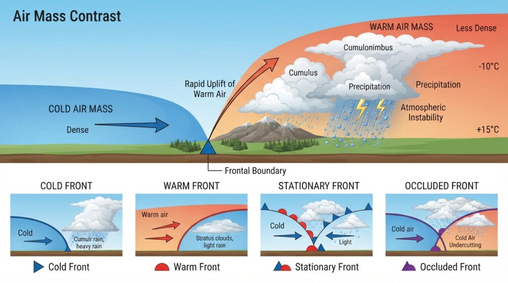
A cold front forms when a cold air mass advances and undercuts a warmer one, forcing warm air sharply upward. This rapid lifting produces cumulonimbus clouds, heavy rain, gusty winds, and sometimes severe thunderstorms. Cold fronts tend to move quickly—typically at 25 to 50 kilometers per hour—and the weather associated with them, while intense, often passes within a few hours.
A warm front occurs when a warm air mass advances over a retreating cold air mass. The warm air rises gradually along the gently sloping frontal boundary, producing broad areas of stratiform cloud and steady precipitation that can persist for a day or more before the front passes.
Stationary fronts develop when two air masses meet but neither has sufficient momentum to displace the other. These boundaries can stall over a region for several days, producing prolonged cloudy, rainy conditions.
Occluded fronts form when a faster-moving cold front catches up with a warm front, lifting the warm air entirely off the surface. They are common in mature mid-latitude cyclones and are typically associated with extensive cloud cover and precipitation.
The Broader Impact of Air Masses on Regional Climates
Beyond individual weather events, air masses exert a profound influence on the long-term climate of regions they frequently affect. The continental interiors of North America and Eurasia experience extreme seasonal temperature swings precisely because they are alternately dominated by cold polar air in winter and hot continental tropical air in summer, with maritime air rarely penetrating far enough inland to moderate conditions.
Coastal regions benefit from the moderating influence of maritime air masses. The mild, wet winters of the Pacific Northwest, the temperate summers of Western Europe, and the high humidity of the Gulf Coast all reflect the dominance of maritime air in those areas.
The monsoon systems of South Asia and West Africa represent seasonal reversals in the dominant air mass type over a region. During the South Asian summer monsoon, moist maritime equatorial and maritime tropical air replaces the dry continental air of winter, delivering the rainfall on which billions of people depend for agriculture and water supply. According to the World Meteorological Organization (WMO), the South Asian monsoon accounts for approximately 70–90% of annual rainfall across much of the Indian subcontinent.
Air Masses and the Changing Atmosphere
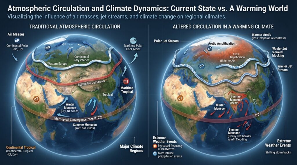
Climate change is altering the behavior of air masses in measurable ways. Arctic warming—occurring at approximately two to four times the global average rate, a phenomenon known as Arctic amplification—is reducing the temperature contrast between polar and mid-latitude regions. Research published in Nature Climate Change suggests that this reduced contrast weakens the jet stream, causing it to develop larger meanders that allow cold polar air masses to plunge further south and warm tropical air masses to push further north than historical averages.
These shifts have practical consequences. Prolonged cold outbreaks in mid-latitude regions, extended heat waves, and disrupted precipitation patterns are all linked, at least in part, to changes in how air masses form, move, and interact under a warming climate.
The Science That Underpins Everyday Weather
Air masses are not abstract meteorological concepts. They are the physical explanation behind every cold snap, heat wave, foggy morning, and summer thunderstorm. By understanding where an air mass comes from, what surface it formed over, and where it is heading, meteorologists can make accurate forecasts days in advance—forecasts that protect lives, guide agricultural decisions, and inform energy demand planning.
The classification system developed in the early twentieth century by Norwegian meteorologists Vilhelm Bjerknes and his colleagues remains the foundation of modern synoptic meteorology. It is a reminder that some of the most powerful explanatory frameworks in science are also among the most elegantly structured. The next time the weather shifts dramatically overnight, the explanation almost certainly lies in the movement of an air mass from somewhere far away—carrying the memory of the surface that shaped it.