

Synoptic meteorology—the large-scale analysis of atmospheric conditions—forms the scientific backbone of modern severe weather forecasting. By examining pressure systems, frontal boundaries, wind patterns, and upper-level dynamics simultaneously, meteorologists can predict dangerous weather events hours or even days before they occur, protecting lives and infrastructure.
Every tornado warning, hurricane track forecast, and flash flood advisory begins the same way: with a meteorologist studying the big picture. That big picture has a name—synoptic meteorology—and understanding it is key to appreciating how modern severe weather prediction actually works.
Synoptic meteorology is the branch of atmospheric science concerned with analyzing weather patterns at a large spatial scale, typically spanning hundreds to thousands of kilometers. The word “synoptic” comes from the Greek synoptikos, meaning “seeing everything together.” And that’s precisely what this discipline demands: a simultaneous view of pressure systems, air masses, frontal zones, moisture fields, and upper-level winds across entire continents, all at the same point in time.
This kind of broad-scale analysis isn’t just academic. It is operationally critical. Without a synoptic understanding of the atmosphere, identifying where severe weather is most likely to develop becomes an educated guess rather than a scientifically grounded forecast. Meteorologists at national weather services, emergency management agencies, and broadcast outlets rely on synoptic tools every day to issue the timely warnings that save lives.
This article explores the foundations of synoptic meteorology, the tools and techniques it employs, and the ways it drives modern severe weather prediction—from tornadoes and derechos to winter storms and tropical cyclones.
The Foundations of Synoptic Meteorology
Synoptic meteorology took shape in the mid-nineteenth century when the invention of the telegraph made it possible to collect weather observations from multiple distant locations simultaneously. Before that, meteorologists could only analyze the atmosphere one location at a time. The telegraph changed everything—suddenly, an observer in New York could know within minutes what the sky looked like in Chicago, Boston, and New Orleans.
The next major leap came with the Bergen School of Meteorology in Norway during the early twentieth century. Vilhelm Bjerknes and his colleagues—including Jacob Bjerknes, Halvor Solberg, and Tor Bergeron—developed the concept of air masses and frontal systems that remains central to synoptic analysis today. Their polar front theory explained how the collision of warm and cold air masses generates the storm systems that dominate mid-latitude weather.
These ideas gave meteorologists a conceptual framework for understanding large-scale atmospheric behavior. Combined with systematic surface observation networks and, later, upper-air soundings from weather balloons, synoptic meteorology became the dominant approach to operational weather forecasting throughout the twentieth century.
Air Masses and Frontal Boundaries
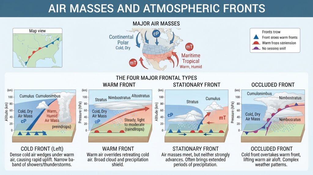
At the core of synoptic analysis is the concept of the air mass—a large body of air with relatively uniform temperature and humidity characteristics. Air masses acquire these characteristics from the surface over which they form. Continental polar air, for example, is cold and dry, originating over northern Canada and Siberia. Maritime tropical air is warm and moisture-laden, flowing northward from subtropical ocean surfaces.
Frontal boundaries form where two air masses of different densities meet. Because cold air is denser than warm air, it does not mix easily with warmer air at the boundary; instead, it undercuts or overrides it. The result is a zone of sharp temperature, pressure, and wind contrasts that is highly favorable for the development of clouds and precipitation.
Cold fronts, warm fronts, stationary fronts, and occluded fronts each produce distinct weather signatures. Cold fronts, for instance, are typically associated with narrow but intense bands of convective weather, including thunderstorms and, in favorable environments, tornadoes. Warm fronts tend to produce broad areas of stratiform precipitation, including snow and freezing rain during winter months. Understanding frontal structure and movement is therefore one of the first steps in any severe weather forecast.
The Role of Pressure Systems and Atmospheric Flow
Synoptic-scale pressure systems organize the large-scale flow of air across the atmosphere. Low-pressure systems, also known as cyclones or lows, are areas where the atmosphere converges near the surface and air rises. This upward motion encourages cloud formation and precipitation. High-pressure systems, or anticyclones, promote descending air and generally clear, dry conditions.
The behavior of these systems is strongly influenced by the jet stream—a narrow, fast-moving band of upper-level winds typically found between 8 and 12 kilometers above Earth’s surface. The jet stream steers surface weather systems, determines how quickly storms develop and decay, and plays a critical role in setting up the atmospheric patterns that favor severe weather outbreaks.
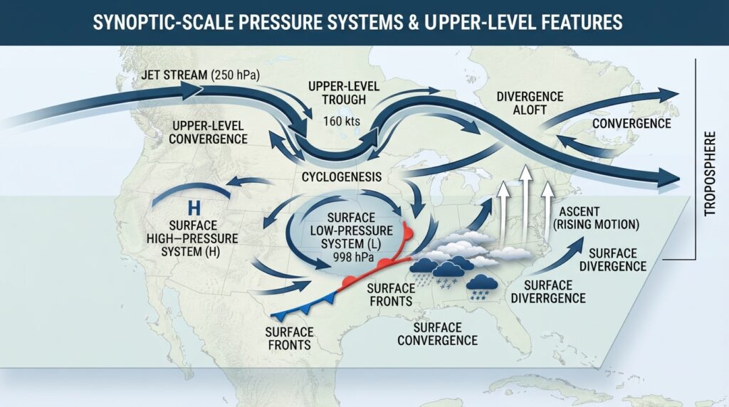
When the jet stream dips southward in a pronounced trough configuration, it creates conditions that support cyclogenesis—the development or intensification of low-pressure systems. These rapidly deepening lows can draw warm, moist air northward at low levels while simultaneously pulling cold air southward at upper levels, establishing the kind of thermodynamic contrast that fuels explosive storm development.
Upper-Level Dynamics and Severe Weather Potential
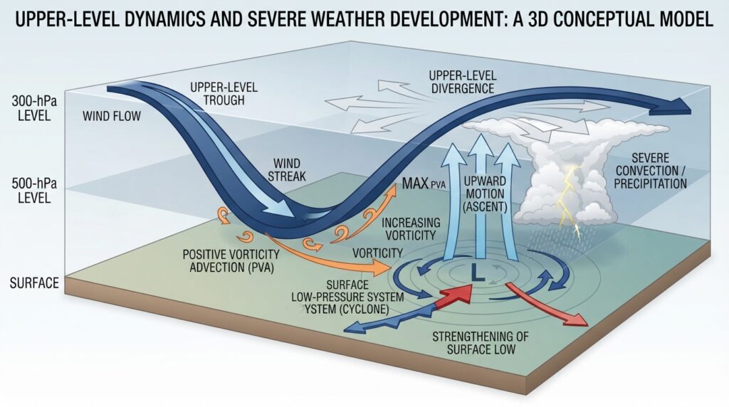
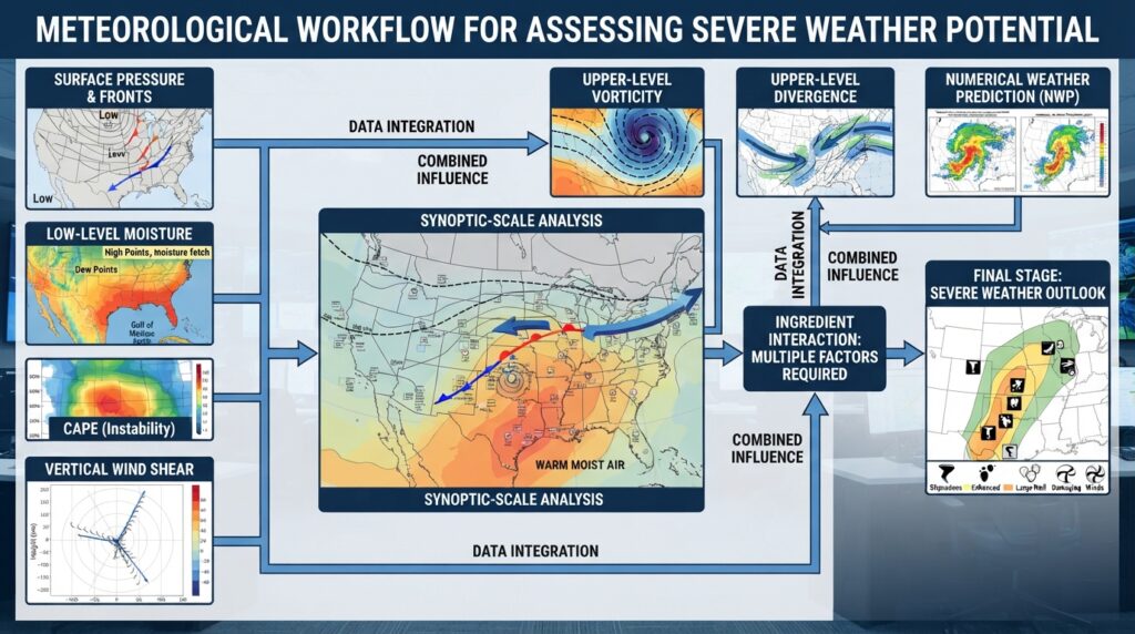
Surface observations tell meteorologists what is happening at ground level, but severe weather is fundamentally driven by processes throughout the depth of the troposphere. Upper-level analysis, particularly the examination of 500-millibar and 300-millibar charts, reveals the behavior of the jet stream, the presence of short-wave troughs, and the distribution of vorticity—a measure of atmospheric rotation that plays a key role in storm intensification.
Positive vorticity advection—the transport of rotating air into a region—promotes rising motion in the atmosphere. When this coincides with surface convergence along a frontal boundary and strong low-level moisture, the ingredients for severe thunderstorm development align. Synoptic meteorologists look for precisely these overlapping signals when assessing the potential for significant weather events.
Divergence at upper levels is equally important. When air diverges aloft, it essentially removes air from the upper atmosphere, which draws more air upward from below, reinforcing surface low development and encouraging sustained convective activity. Recognizing areas of upper-level divergence on synoptic charts allows forecasters to anticipate where the atmosphere will be most dynamically active.
Thermodynamic Parameters and the Synoptic Setup
While synoptic meteorology focuses on large-scale patterns, its outputs directly inform the calculation of thermodynamic parameters used in severe weather forecasting. Atmospheric sounding data from weather balloons—collected twice daily at locations worldwide—provide vertical profiles of temperature, moisture, and wind. These profiles are analyzed using meteorological indices that quantify the atmosphere’s potential to support severe weather.
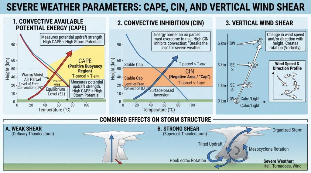
Convective Available Potential Energy (CAPE) measures how much energy is available to a rising parcel of air. High CAPE values indicate an atmosphere that can sustain powerful updrafts, capable of generating large hail, damaging winds, and tornadoes. Convective Inhibition (CIN) measures the energy required to initiate convection—a lid that prevents storm development until conditions become favorable enough to break through it.
Wind shear, the change in wind speed and direction with height, is another parameter of critical importance. Environments with strong vertical wind shear support supercell thunderstorms—the storm type most commonly associated with significant tornadoes and very large hail. The synoptic setup determines whether the necessary shear exists across a region before any individual storm even develops.
Numerical Weather Prediction as a Synoptic Tool
Modern synoptic meteorology would be unrecognizable without numerical weather prediction (NWP)—the use of mathematical models to simulate the future state of the atmosphere. These models solve complex equations governing atmospheric dynamics and thermodynamics, initialized with observations from surface stations, weather balloons, satellites, and radar.
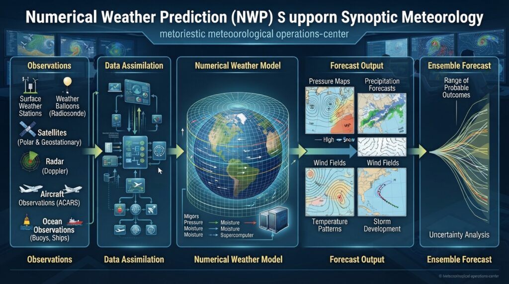
Global models such as the GFS (Global Forecast System) and the ECMWF (European Centre for Medium-Range Weather Forecasts) provide synoptic-scale guidance several days into the future. Regional models like the NAM (North American Mesoscale Model) and the HRRR (High-Resolution Rapid Refresh) offer more detailed, higher-resolution output at shorter time ranges, bridging the gap between synoptic forecasting and mesoscale analysis.
Ensemble forecasting—running multiple versions of a model with slightly varied initial conditions—has become an essential tool for capturing forecast uncertainty. Rather than relying on a single deterministic solution, meteorologists study the spread of ensemble members to assess confidence levels and identify scenarios in which severe weather outcomes could be significantly worse than the primary forecast.
Synoptic Meteorology in Operational Forecasting
At operational weather centers, synoptic analysis is the starting point for every severe weather forecast cycle. Meteorologists begin by examining the current synoptic pattern—where the surface lows and fronts are, how the jet stream is configured, and what the upper-level flow looks like. They then assess how this pattern is expected to evolve over the next one to seven days using model guidance.
The Storm Prediction Center (SPC) in the United States, for example, issues convective outlooks that classify areas by their probability of experiencing severe weather. These outlooks are grounded in synoptic analysis. A Day 3 outlook issued for the central plains might highlight an area where a developing surface low, advancing cold front, and favorable upper-level pattern are expected to coincide with high-CAPE, high-shear conditions later in the week.
Similar frameworks operate in other parts of the world. The European Severe Storms Laboratory (ESSL), the Met Office in the United Kingdom, and the Japan Meteorological Agency all employ synoptic-based forecasting frameworks adapted to their respective regional climates.
Synoptic Meteorology and Tropical Weather Systems
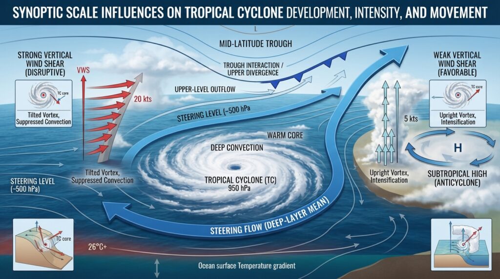
Tropical cyclone forecasting also relies heavily on synoptic analysis. While tropical systems are driven primarily by sea surface temperatures and latent heat release, their formation, intensification, and track are significantly influenced by the broader synoptic environment.
The presence or absence of upper-level wind shear—determined largely by the synoptic-scale flow—is one of the most important factors in tropical cyclone intensity. Strong shear disrupts the vertical structure of a storm, ventilating the warm core and inhibiting intensification. Conversely, a low-shear environment supported by a favorable synoptic pattern allows a tropical system to rapidly intensify, sometimes reaching major hurricane status within 24 to 48 hours.
The steering flow—the large-scale wind pattern that determines where a tropical cyclone moves—is a direct product of synoptic analysis. Forecasters track the position and strength of subtropical high-pressure ridges, mid-latitude troughs, and other features that guide storms toward or away from populated areas.
The Continued Relevance of Synoptic Thinking
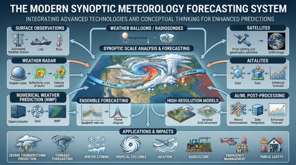
Advances in computing power, satellite remote sensing, and machine learning have transformed the tools available to meteorologists. High-resolution modeling, artificial intelligence-based post-processing, and real-time radar analysis have all expanded forecasting capabilities in remarkable ways. Yet the conceptual framework of synoptic meteorology has not been displaced—it has been enhanced.
The fundamental questions that synoptic analysis addresses remain unchanged: Where is the energy in the atmosphere concentrated? What processes are organizing the large-scale flow? Under what synoptic regime will local weather develop? These questions require the kind of broad, integrative thinking that synoptic meteorology uniquely provides. No algorithm answers them in isolation; they require contextual understanding built from decades of scientific development.
Severe weather prediction will continue to evolve, but the synoptic perspective—seeing everything together—will remain at its foundation.
The Science That Stands Between Storms and Society
Synoptic meteorology is not simply a technical discipline confined to weather offices and academic journals. Its applications touch every sector of society that is vulnerable to weather extremes—agriculture, aviation, emergency management, energy, transportation, and public health.
Accurate severe weather forecasting buys time. A tornado warning issued 15 minutes before a twister strikes gives families time to reach shelter. A well-forecast winter storm allows highway departments to pre-treat roads and emergency managers to position resources. A correctly predicted hurricane track gives coastal communities days to prepare or evacuate. All of these outcomes trace back, in some measure, to a meteorologist studying a synoptic map and reading the signals written across the atmosphere.
Investing in the science of synoptic meteorology—through education, research, and operational infrastructure—is therefore an investment in societal resilience. The atmosphere does not wait, and neither can the science that seeks to understand it.