

Egypt occupies a singular place on the world map, anchored in the northeastern corner of Africa while extending into Asia through the Sinai Peninsula. This transcontinental position, combined with the presence of the Nile River, the Mediterranean and Red Sea coastlines, and the Suez Canal, has made Egypt one of the most geographically consequential countries on Earth. Its physical geography is a study in contrasts: a nation that is overwhelmingly desert, yet home to one of the densest concentrations of population and agriculture found anywhere in the world, all squeezed into the narrow ribbon of the Nile Valley and the fan-shaped expanse of the Nile Delta.
Understanding Egypt geography means understanding how a single river system has organized nearly every dimension of national life—settlement patterns, agriculture, transportation, history, and economic development—against a backdrop of vast, arid desert. It also means recognizing Egypt’s regional importance as a bridge linking Africa, the Middle East, and the Mediterranean world, reinforced by the Suez Canal’s role in global shipping. The following overview examines Egypt’s physical landscapes, geology, water resources, population patterns, economic activities, and environmental challenges in order to present a complete geographical profile of this distinctive country.
Geographical Location and Regional Setting
Egypt sits in the northeastern quadrant of the African continent, bordered by the Mediterranean Sea to the north and the Red Sea to the east. Libya lies along its western border, while Sudan borders it to the south. To the northeast, the Sinai Peninsula extends Egyptian territory into Asia, creating a direct land connection with Israel and the Palestinian territories and giving Egypt a foothold on two continents.
This dual-continent character places Egypt simultaneously within North Africa and at the doorstep of the Middle East, making it a pivotal link between Africa, Asia, and, through Mediterranean trade routes, Europe. According to World Bank data, Egypt’s total surface area is approximately 1.001 million square kilometers, and its population reached an estimated 118.4 million in 2025.
The country’s coastlines are extensive, with roughly 1,000 kilometers along the Mediterranean and approximately 1,800 kilometers along the Red Sea, including the Gulf of Suez and Gulf of Aqaba. These coastlines, combined with the Suez Canal’s position connecting the two seas, give Egypt exceptional strategic weight in global maritime trade. Few countries combine river valley agriculture, desert vastness, dual sea access, and a transcontinental land bridge within a single national territory, and this combination defines Egypt’s geographical identity.

Physical Geography and Major Landforms
Egypt’s landscape divides into several distinct physical regions: the Nile Valley, the Nile Delta, the Western Desert, the Eastern Desert, and the Sinai Peninsula. Although these regions differ dramatically in terrain and ecology, they share a common theme—extreme aridity punctuated by narrow zones of water availability.
The Nile Valley forms a narrow green corridor running from Egypt’s southern border north to Cairo, flanked on both sides by desert plateaus and cliffs. North of Cairo, the Nile spreads into its Delta, a broad triangular floodplain reaching the Mediterranean. West of the river lies the Western Desert, an immense expanse of sand seas, gravel plains, and isolated depressions, including the dramatic Qattara Depression and the Siwa oasis region. East of the Nile Valley, the Eastern Desert rises into the rugged Red Sea Hills before descending to the Red Sea coastal plain. The Sinai Peninsula, a wedge-shaped landmass, contains some of Egypt’s highest mountains alongside coastal plains along the Gulf of Suez and Gulf of Aqaba.

This arrangement produces a striking geographical contrast: more than ninety percent of Egypt’s land area consists of desert, yet the vast majority of the population lives within the Nile Valley and Delta, which together cover only a small fraction of the country’s total territory. Landforms directly shape where people settle, where crops grow, how water is distributed, and how goods and people move across the country. Desert plateaus have historically isolated communities and limited agricultural expansion, while the flat, fertile Nile floodplain has supported dense settlement and intensive farming for millennia. Wadis—dry riverbeds that occasionally flood—cut through both deserts and serve as natural transportation corridors as well as sources of episodic water supply.
Geology and Tectonic Setting
Egypt’s geological foundation consists of ancient Precambrian basement rocks, most prominently exposed in the Eastern Desert and southern Sinai, overlain in much of the country by younger sedimentary formations. The Western Desert is underlain by extensive sedimentary basins containing layers of sandstone, limestone, and shale deposited over hundreds of millions of years as shallow seas repeatedly advanced and retreated across the region.
The Nile Valley itself developed through a combination of tectonic downwarping and fluvial erosion and deposition, with the river cutting its course through limestone plateaus and depositing thick layers of silt that form the fertile agricultural soils of the valley and Delta today. The Eastern Desert and Sinai contain crystalline basement rocks associated with the Arabian-Nubian Shield, a geological province formed through ancient volcanic and tectonic activity.
Egypt’s geology is closely tied to the broader tectonic framework of the Red Sea Rift, where the African and Arabian tectonic plates are gradually separating. This rifting process, which began tens of millions of years ago, created the Red Sea basin itself and continues to influence faulting and uplift in the Eastern Desert and Sinai Peninsula, where mountain ranges have been pushed upward along fault lines. These geological processes carry significant practical importance: the sedimentary basins of the Western Desert, Nile Delta, and offshore Mediterranean host substantial petroleum and natural gas reserves, while the crystalline rocks of the Eastern Desert and Sinai contain valuable mineral deposits, including gold and phosphate. Groundwater aquifers trapped within these sedimentary layers also sustain desert oases far from the Nile.

The Nile River and Drainage System
No discussion of Egypt geography can proceed without emphasizing the Nile River, which functions as the country’s lifeline. The Nile reaches Egypt as a single channel formed far upstream by the convergence of the White Nile and Blue Nile in Sudan. Within Egyptian territory, the river flows northward through a narrow valley bordered by desert escarpments before fanning out into the Delta as it approaches the Mediterranean.
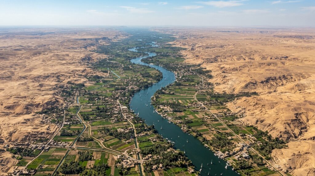
The construction of the Aswan High Dam, completed in 1970, transformed the Nile’s role in Egypt by creating Lake Nasser, one of the largest reservoirs in the world. This engineering achievement allowed for year-round water storage and flood control, replacing the river’s historic seasonal flooding with managed irrigation delivered through an extensive network of canals and drainage channels. These engineered systems now sustain agriculture across virtually the entire cultivated area of the country.
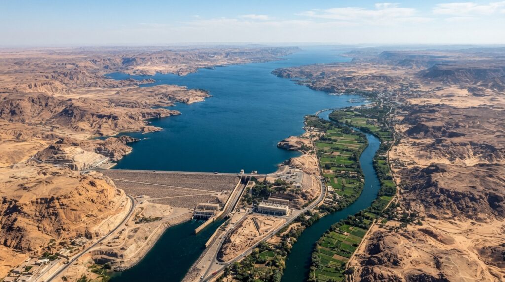
The Nile’s importance to Egypt extends across nearly every sector of life. It supplies the overwhelming majority of the country’s freshwater for drinking, irrigation, and industrial use. It supports inland fisheries and sustains riverine ecosystems, while also serving as a historic transportation corridor linking Upper and Lower Egypt. It is essential to distinguish Egypt’s domestic Nile geography—the stretch of river, valley, and Delta within Egyptian borders—from the geography of the broader Nile Basin, which includes major tributary systems and watershed areas across multiple countries in East and Central Africa. Egypt depends almost entirely on water that originates far beyond its own borders, a reality that shapes much of its water resource planning.
Nile Delta and Mediterranean Coastal Region
The Nile Delta represents one of the most agriculturally and demographically significant landscapes in Egypt. Formed over thousands of years as the river deposited sediment upon reaching the flatter terrain near the Mediterranean, the Delta spreads out in a fan shape bounded by two main distributaries, the Rosetta and Damietta branches, along with numerous smaller canals and waterways.
The Delta’s fertile soils support intensive agriculture, while its network of coastal lagoons and wetlands provides important habitat for fish and migratory birds. Major urban centers have grown along its margins and waterways, including Alexandria on the Mediterranean coast, along with Port Said, Damietta, and Rosetta, all of which combine historical significance with modern roles in fishing, trade, and industry. Alexandria in particular functions as Egypt’s principal Mediterranean port and a major center of commerce and culture.

The Delta faces mounting environmental pressures. Its low elevation makes it acutely vulnerable to sea-level rise and coastal erosion, while land subsidence—the gradual sinking of the delta plain due to both natural sediment compaction and reduced sediment supply following the construction of the Aswan High Dam—compounds these risks. Saltwater intrusion into coastal aquifers and agricultural soils threatens freshwater supplies and crop productivity, while dense population growth and pollution place additional strain on wetlands and water quality. As one of the most intensively used and densely populated landscapes in Egypt, the Nile Delta illustrates the close interdependence between physical geography and human activity.
Western Desert
The Western Desert, sometimes referred to historically as part of the Libyan Desert, extends across more than two-thirds of Egypt’s total land area, yet it is far from a uniform expanse of sand. Its terrain includes rocky plateaus, gravel plains, extensive sand seas such as the Great Sand Sea along the Libyan border, and several significant depressions.
The Qattara Depression, one of the lowest points in Africa, drops well below sea level and spans a vast salt-marsh and dune landscape unsuitable for settlement. In contrast, the Siwa, Bahariya, Farafra, Dakhla, and Kharga oases rely on groundwater drawn from deep aquifers to support agricultural communities amid otherwise extreme aridity. These oases have historically served as important stops along desert trade and travel routes and continue to sustain distinct agricultural and cultural communities today, cultivating dates, olives, and other crops through groundwater irrigation. The presence of accessible groundwater, rather than surface water, is what allows human settlement to persist in these isolated pockets within an otherwise inhospitable desert environment.

Eastern Desert and Red Sea Region
Between the Nile Valley and the Red Sea lies the Eastern Desert, a rugged landscape dominated by the Red Sea Hills, a mountainous spine running roughly parallel to the coast. This region differs markedly from the sandy expanses of the Western Desert, featuring exposed crystalline rock formations, steep wadis, and mineral-rich geology that has historically supported mining activity, including gold extraction dating back to ancient times.
The Eastern Desert narrows toward the Red Sea coastal plain, where mountains give way to flatter terrain before meeting the shoreline. The Red Sea itself is renowned for its clear waters and extensive coral reef systems, which support rich marine ecosystems and have made coastal towns such as Hurghada and Safaga major centers for tourism, diving, and recreational activity. The Eastern Desert functions as a geographical transition zone, connecting the agricultural heartland of the Nile Valley with the maritime economy of the Red Sea coast, while also providing transportation routes and mineral resources that contribute to the national economy.

Sinai Peninsula
The Sinai Peninsula holds a distinctive place in Egypt geography as the only portion of the country situated in Asia rather than Africa, bridging the two continents at the northeastern edge of Egyptian territory. The peninsula is bounded by the Gulf of Suez to the west and the Gulf of Aqaba to the east, both arms of the Red Sea, with the Mediterranean Sea along its northern coast.
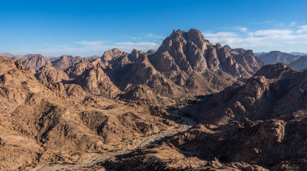
Sinai divides geographically into a northern region characterized by coastal plains and sand dunes, and a southern region dominated by a rugged, mountainous plateau. The highest elevations in Egypt are found here, including Mount Catherine, which rises to approximately 2,629 meters, along with the nearby Mount Sinai. These mountains create a dramatically different climate and landscape from the surrounding deserts, with cooler temperatures at higher elevations. Wadis cut through the Sinai interior, while the coastal zones along both gulfs support important marine ecosystems, coral reefs, and tourism development, particularly around the southern tip of the peninsula. Sinai’s combination of desert terrain, mountain scenery, and coastal environments gives it considerable ecological and touristic significance within Egypt’s broader geography, in addition to its role as a transportation link between the African mainland and the Asian continent.
Climate and Weather Patterns
Egypt’s climate is predominantly arid to hyper-arid, classified broadly as a desert climate across most of the country, with a narrow strip of Mediterranean influence along the northern coast. Rainfall is minimal throughout the vast majority of Egyptian territory, with many interior desert areas receiving only a few millimeters annually, while coastal cities like Alexandria receive modestly higher winter precipitation due to Mediterranean weather systems.
Temperature patterns vary by region and season. Summers are intensely hot across the country, particularly in the desert interior and Upper Egypt, where daytime temperatures frequently exceed 40 degrees Celsius. Winters are considerably milder, especially along the Mediterranean coast, while desert regions can experience significant temperature swings between day and night due to low humidity and clear skies. The Sinai’s mountainous interior experiences cooler conditions, including occasional winter snowfall at higher elevations, a notable contrast to the surrounding lowland deserts.
Seasonal winds known as the Khamsin bring hot, dry conditions and occasional dust and sandstorms, typically during spring months, reducing visibility and affecting daily life and transportation. Although rainfall is rare, intense localized storms can trigger flash floods within desert wadis, posing hazards to settlements and infrastructure built in or near these channels. Egypt’s climate is shaped by its low latitude, extensive desert geography, limited elevation outside Sinai, and distance from major moisture sources, producing one of the driest national climates in the world.

Soils, Vegetation, and Ecosystems
Egypt’s ecosystems are closely tied to the availability of water. The Nile Valley and Delta contain the country’s most fertile soils, built up over millennia through river-deposited silt, and these support the bulk of Egyptian agriculture. Oasis soils in the Western Desert, while less extensive, similarly depend on groundwater to sustain cultivation.
Outside these zones, desert soils dominate, generally sandy or rocky and low in organic content, supporting only sparse, drought-adapted vegetation such as scattered shrubs and grasses that appear briefly after rare rainfall events. Along the Mediterranean coast, slightly higher rainfall supports somewhat denser vegetation patterns compared to the deep interior desert. The Nile Delta’s wetlands and coastal lagoons form ecologically rich habitats, supporting reed beds, aquatic plants, and large populations of resident and migratory birds. Along the Red Sea coast, the marine environment features extensive coral reef ecosystems that rank among the most biologically diverse in the region, supporting a wide array of fish and invertebrate species.
The relationship between water, soil, and vegetation in Egypt is direct and unforgiving: wherever water is available, whether through the Nile, groundwater, or coastal moisture, vegetation and human settlement follow; everywhere else, desert conditions prevail. The Nile Delta wetlands and Red Sea coral ecosystems stand out as particularly significant ecological assets, supporting both biodiversity and economic activities such as fishing and tourism.
Wildlife and Biodiversity
Egypt’s biodiversity reflects its range of environments, from riverine and desert habitats to Mediterranean, Sinai mountain, and Red Sea marine ecosystems. Desert regions support hardy mammals such as gazelles and the small, large-eared fennec fox, alongside various reptile species adapted to extreme heat and aridity. The Nile Valley and Delta wetlands provide critical habitat for numerous bird species, including both resident populations and migratory birds that use Egypt as a stopover along major flyways between Europe, Asia, and Africa.

The Red Sea stands out for its coral reef biodiversity, hosting a wide variety of fish, mollusks, and other marine organisms within one of the world’s notable reef systems. The Sinai Peninsula’s mountainous terrain and coastal zones add further ecological variety, supporting species adapted to both highland and arid coastal conditions. Protected areas across these environments play an important role in conserving habitat for desert wildlife, wetland birds, and marine life, helping to safeguard biodiversity amid pressures from development, tourism, and climate change.
Population and Settlement Geography
Egypt’s population distribution is exceptionally uneven, a direct consequence of its water-dependent geography. The overwhelming majority of Egyptians live within the Nile Valley and Delta, a region comprising only a small percentage of the country’s total land area, while the extensive desert territories remain sparsely inhabited. According to World Bank data, Egypt’s population stood at approximately 116.5 million in 2024, rising to an estimated 118.4 million in 2025.
Cairo, Egypt’s capital and largest metropolitan area, anchors the southern apex of the Delta and has grown into one of the largest urban agglomerations in Africa and the Middle East, encompassing Giza and surrounding urban areas. Alexandria remains the country’s second-largest city and principal Mediterranean port. Beyond these major centers, population clusters along the Nile Valley in Upper Egypt, within Delta towns and cities, and increasingly in newly planned urban communities developed in desert areas to relieve pressure on the crowded Nile corridor.
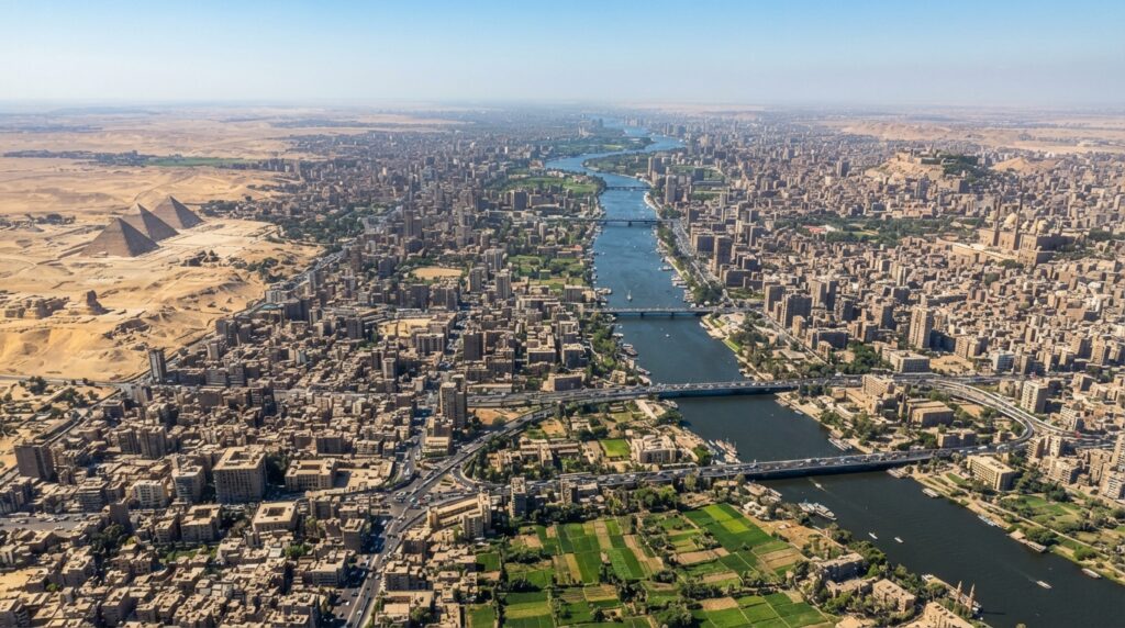
Oasis settlements in the Western Desert, communities in Sinai, and coastal towns along the Red Sea represent smaller but geographically significant population centers located outside the Nile system. This settlement pattern produces extremely high population density within inhabited zones, placing considerable pressure on agricultural land, housing, and infrastructure, even as desert urbanization initiatives attempt to redistribute growth away from the overburdened Nile Valley and Delta.
Peoples, Languages, and Cultural Geography
Egypt’s cultural geography reflects a long history of settlement, migration, and regional connection. The majority of Egyptians identify with Egyptian Arab cultural identity and speak Egyptian Arabic, a distinct dialect within the broader Arabic language family, alongside Modern Standard Arabic used in formal and written contexts. Coptic heritage, rooted in Egypt’s pre-Islamic Christian history, remains an important cultural thread, particularly within certain communities in Upper Egypt and urban centers.
Nubian communities, historically associated with the southern Nile Valley near Aswan and the Sudanese border, maintain distinct linguistic and cultural traditions shaped by the river environment. Bedouin communities inhabit parts of the Sinai Peninsula and Eastern Desert, with lifestyles historically adapted to desert and semi-arid conditions, while oasis communities in the Western Desert have developed distinct agricultural and social patterns shaped by isolation and reliance on groundwater. Urban centers such as Cairo and Alexandria display more cosmopolitan cultural patterns shaped by trade, migration, and historical interaction with Mediterranean and Middle Eastern societies, in contrast to more traditional rural patterns found in Delta and Upper Egypt villages. This cultural diversity has been shaped over centuries by the unifying presence of the Nile, the isolating effect of surrounding deserts, and Egypt’s long-standing role as a crossroads for trade and migration between Africa, the Middle East, and the Mediterranean world.
Historical Geography
Egypt’s physical geography has shaped its historical trajectory since antiquity. Ancient Egyptian civilization developed directly along the Nile Valley and Delta, where predictable seasonal flooding once deposited fertile silt, enabling organized agriculture, food surpluses, and the rise of complex urban centers and monumental construction. Major ancient settlements, including Memphis and Thebes, were positioned to take advantage of the river’s resources and transportation capabilities.
Subsequent periods of Hellenistic and Roman rule capitalized on Egypt’s Mediterranean access and agricultural productivity, integrating the country into broader Mediterranean trade networks, with Alexandria emerging as a major center of commerce and scholarship. Christian and Coptic Egypt developed during the Roman and Byzantine periods, followed by the Islamic conquest, which brought Egypt into new political and cultural networks centered on Cairo, founded as a new capital that capitalized on its strategic position near the Delta’s apex. The Ottoman period maintained Egypt’s role as a key trade and administrative center linking Africa, the Middle East, and the Mediterranean.
The construction of the Suez Canal in the nineteenth century dramatically elevated Egypt’s geopolitical and economic significance by creating a direct maritime link between the Mediterranean and Red Seas, reshaping global shipping routes and drawing substantial British strategic interest. Following independence, modern Egypt continued to build upon these same geographical foundations—the Nile, the Delta, the Mediterranean, and the Suez Canal—as the basis for agricultural, industrial, and economic development. Throughout these historical periods, the enduring geographical realities of river, desert, and sea have consistently shaped patterns of trade, settlement, defense, and cultural exchange.
Agriculture and Rural Geography
Agriculture in Egypt remains deeply tied to the Nile Valley and Delta, where irrigation from the river sustains the cultivation of crops including wheat, maize, rice, cotton, sugarcane, vegetables, fruits, and dates. Reclaimed desert lands, developed through extended irrigation infrastructure, have gradually expanded the agricultural footprint beyond the traditional floodplain, supporting livestock raising and diversified crop production.
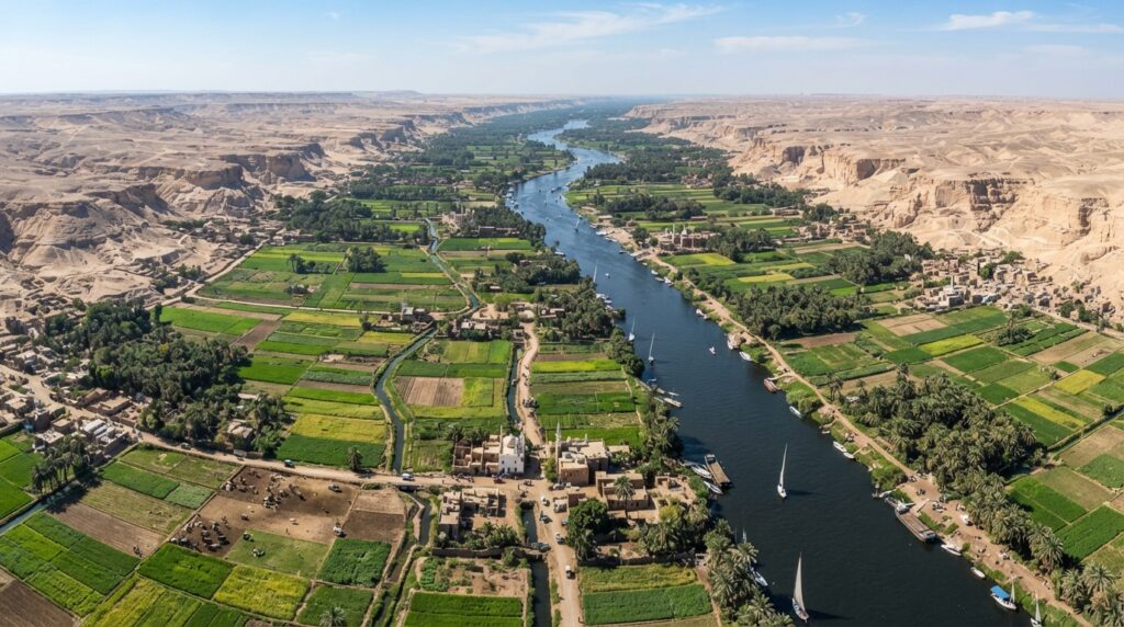
Despite these efforts, Egypt’s arable land remains limited relative to its large and growing population, creating significant pressure on agricultural resources. Soil fertility within the Nile Valley and Delta remains generally high due to historical silt deposition, though modern irrigation practices require careful management to avoid soil salinity, a growing concern in parts of the Delta. Land fragmentation, resulting from inheritance practices and population pressure, has reduced average farm sizes over time, while ongoing efforts to reclaim and irrigate desert land aim to offset the loss of agricultural area to urban expansion. Fisheries, both along the Nile and within coastal and lake environments, contribute additional agricultural output, while oasis agriculture in the Western Desert adds further, if limited, productive capacity.
Water Resources and Water Security
Egypt’s dependence on the Nile River for water resources is nearly absolute, with the river supplying the vast majority of the country’s needs for irrigation, drinking water, and industrial use. This dependence is compounded by the fact that the Nile originates largely outside Egyptian territory, making the country reliant on a transboundary river system shared with multiple upstream nations within the broader Nile Basin.
Egypt has developed groundwater extraction in desert oases and increasingly looked to desalination and water reuse technologies to supplement its freshwater supply, particularly along the Red Sea coast and in areas distant from the Nile. However, the Nile remains overwhelmingly dominant as a water source. Rising agricultural demand, industrial growth, and continued population increase place sustained pressure on available water resources, reinforcing the importance of efficient irrigation practices and water management within Egypt’s own borders. While Egypt’s water security is closely connected to broader Nile Basin geography, the country’s domestic water management—its irrigation networks, reservoirs, and distribution systems—operates as a distinct system built around the water that reaches Egyptian territory each year.
Natural Resources and Economic Geography
Egypt possesses a varied natural resource base that supports significant sectors of its economy. Petroleum and natural gas are extracted from several geological basins, including the Western Desert, the Nile Delta, offshore fields in the Mediterranean, and the Gulf of Suez, making energy production an important component of the national economy. Additional mineral resources include gold, primarily mined in the Eastern Desert, along with phosphate, iron ore, limestone, and manganese deposits distributed across various geological formations.
Beyond subsurface resources, Egypt’s extensive desert expanses offer considerable potential for solar energy generation due to high levels of sustained sunlight, while coastal and desert wind patterns, particularly near the Gulf of Suez, support growing wind-energy development. Fisheries along the Nile, Mediterranean, and Red Sea coasts, along with the agricultural output of the Nile Valley and Delta, round out Egypt’s natural resource profile. The geographical distribution of these resources closely aligns with the country’s major economic zones, with energy and mineral extraction concentrated in desert basins and coastal waters, and agricultural production centered on the Nile corridor.
Energy Geography
Egypt’s energy sector draws on a combination of oil, natural gas, and a growing renewable energy base. Natural gas production, particularly from offshore Mediterranean fields and Delta basins, has become an increasingly significant component of the national energy mix, supporting both domestic electricity generation and export potential through established pipeline and liquefied natural gas infrastructure.
Electricity generation relies on a mix of natural gas, hydropower from the Aswan High Dam, and an expanding share of solar and wind capacity, reflecting the country’s substantial renewable energy potential given its desert sunlight and favorable wind corridors. Egypt’s position linking Africa, the Middle East, and Mediterranean markets enhances its potential role as a regional energy hub, with existing and planned pipeline and transmission infrastructure supporting cross-border energy trade. This combination of hydrocarbon resources, renewable potential, and strategic geographic location positions Egypt as a significant player in regional energy geography.
Suez Canal and Transportation Geography
The Suez Canal stands as one of the most geographically and economically significant features in Egypt, and indeed the world, providing a direct maritime link between the Mediterranean Sea and the Red Sea. This artificial waterway eliminates the need for ships traveling between Europe and Asia to navigate around the southern tip of Africa, making it a cornerstone of global shipping and trade routes.
The Suez Canal Zone encompasses key cities including Port Said at the Mediterranean entrance, Suez at the Red Sea terminus, and Ismailia along the canal’s midpoint, all of which have developed substantial economic activity connected to canal operations, shipping services, and associated industry. The canal generates significant revenue for Egypt through transit fees paid by the thousands of vessels that pass through it annually, reinforcing the country’s strategic position in global maritime commerce.
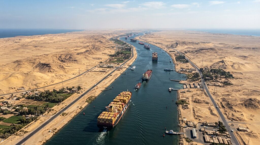
Beyond the canal itself, Egypt’s broader transportation geography includes an extensive network of roads and railways connecting the Nile Valley, Delta, and major urban centers, along with international airports serving Cairo and other key cities. Nile river transportation continues to serve certain domestic needs, while Mediterranean and Red Sea ports support both international trade and regional shipping. Transportation corridors across the Sinai Peninsula further link Egypt’s African mainland with its Asian territory, reflecting the country’s role as a physical bridge between continents.
Industry, Trade, and Economic Geography
Egypt’s economic geography reflects a diversified structure spanning agriculture, manufacturing, energy, tourism, transportation, and services, with Suez Canal operations contributing a notable share of national revenue. Industrial activity is geographically concentrated around Cairo, Alexandria, the Suez Canal region, and parts of the Nile Delta, where access to transportation infrastructure, labor, and urban markets supports manufacturing and processing industries.
Upper Egypt, while historically more agriculturally oriented, has also seen industrial and infrastructure development, though economic activity remains more heavily concentrated in the north. Major ports along both the Mediterranean and Red Sea coasts facilitate international trade, reinforcing Egypt’s position as a regional hub for commerce and logistics. The geographical concentration of industry and trade around key urban and coastal centers mirrors the broader population distribution pattern, with economic activity clustering wherever infrastructure, water access, and transportation networks converge.
Tourism and Geographical Significance
Tourism in Egypt draws directly on the country’s remarkable geographical diversity. Ancient archaeological landscapes along the Nile Valley, including sites in Luxor and Aswan, attract visitors interested in Egypt’s historical geography and monumental heritage, while Cairo offers access to nearby ancient sites alongside its role as a major urban center. Alexandria provides a distinct Mediterranean coastal identity shaped by centuries of historical and cultural exchange.
The Red Sea coast, including resort areas such as Hurghada and Sharm El-Sheikh in southern Sinai, draws tourism centered on marine environments, coral reefs, and warm-water recreation. Desert tourism, including visits to oases such as Siwa and other Western Desert locations, offers access to Egypt’s less-visited arid landscapes and oasis communities. This combination of river valley heritage sites, Mediterranean coastal cities, Red Sea marine environments, and desert and mountain landscapes in Sinai creates a geographically varied tourism sector that draws on nearly every physical region described throughout this profile.
Environmental Challenges
Egypt faces a range of environmental challenges rooted in its arid geography and concentrated population pattern. Water scarcity remains a central concern, given the country’s near-total dependence on the Nile for freshwater amid rising demand. Desertification and land degradation threaten agricultural productivity at the margins of cultivated areas, while soil salinity, driven partly by irrigation practices, reduces yields in parts of the Delta and Nile Valley.
Agricultural land loss to urban expansion compounds pressure on a already limited base of arable land, while rapid urban growth in cities such as Cairo contributes to air pollution, water pollution, and waste management challenges. Wetland degradation within the Nile Delta threatens important bird and fish habitats, and coastal erosion along the Mediterranean shoreline further reduces usable land and infrastructure stability. Groundwater stress in desert oases, resulting from extraction rates that sometimes exceed natural recharge, threatens the long-term viability of these isolated agricultural communities. These challenges are closely interconnected, each stemming from the fundamental tension between a growing population and a geographically constrained resource base.
Climate Change and Geographic Vulnerability
Climate change poses distinct risks across Egypt’s various geographic regions. Rising temperatures and more frequent heat extremes are expected to intensify conditions in a country already characterized by extreme desert heat, while shifting rainfall patterns could affect the limited precipitation received along the Mediterranean coast. Water scarcity concerns are likely to deepen as both climate variability and upstream Nile Basin dynamics affect river flow reaching Egypt.
The Nile Delta faces particular vulnerability due to its low elevation, dense population, intensive agricultural use, and coastal location. World Bank climate assessments identify Egypt’s Mediterranean coastal areas, especially the Delta, as vulnerable to sea-level rise, which threatens to accelerate coastal erosion, increase saltwater intrusion into agricultural soils and aquifers, and displace populations in low-lying areas. Desertification pressures may intensify at the margins of cultivated land, while flash flood risk in desert wadis could increase with more intense, if infrequent, rainfall events. Red Sea coral reef ecosystems also face stress from rising sea temperatures, with potential consequences for marine biodiversity and the tourism industry that depends on healthy reef systems. These interconnected vulnerabilities underscore how closely Egypt’s geography and climate resilience are intertwined.

Protected Areas and Conservation
Egypt has established a network of protected areas spanning its diverse geographic regions. In the Western Desert, Wadi El Rayan protects a unique lake and waterfall system amid surrounding arid terrain, while areas near Siwa safeguard oasis and desert landscapes. Along the Sinai Peninsula, Ras Mohammed and Nabq protect significant marine and coastal ecosystems at the peninsula’s southern tip, while Saint Katherine preserves the mountainous interior, including the area surrounding Mount Sinai.
Wadi El Gemal along the Red Sea coast protects marine habitats alongside coastal desert terrain, and the White Desert showcases distinctive chalk rock formations within the Western Desert’s broader landscape. Lake Qarun, located within the Fayoum Depression, supports important wetland habitat, while various protected areas along the Nile safeguard riverine and wetland ecosystems. Collectively, these protected areas conserve representative samples of Egypt’s desert ecosystems, wetlands, mountain environments, and Red Sea marine habitats, supporting both biodiversity conservation and the preservation of culturally significant archaeological landscapes.
Regional Geographic Importance
Egypt occupies a position of substantial regional significance across North Africa, the Mediterranean world, the Red Sea region, the Nile Basin, and the broader Middle East. Its geographic relationships with Libya and Sudan connect it to North and Northeast African political and economic networks, while its proximity to Israel and the Palestinian territories across the Sinai Peninsula links it directly to Middle Eastern geography.
Within the Nile Basin, Egypt’s position as the most downstream major user of Nile waters ties its interests closely to the broader hydrological and economic geography of upstream countries. Its Mediterranean coastline integrates it into regional trade and transportation networks connecting North Africa and southern Europe, while its Red Sea coastline links it to shipping routes serving the Arabian Peninsula and broader Indian Ocean trade. The Suez Canal remains the single most significant element of Egypt’s regional geographic importance, anchoring its role in global and regional maritime commerce. Combined with its extensive agricultural land along the Nile, its energy resources, and its transportation corridors spanning two continents, Egypt’s strategic geographic position continues to shape its economic and regional significance well beyond its own borders.
Key Geographic Facts
|
Category |
Details |
|---|---|
|
Official Name |
Arab Republic of Egypt |
|
Capital |
Cairo |
|
Region |
Northeastern Africa, with Sinai Peninsula in Asia |
|
Location |
Bordered by the Mediterranean Sea (north), Red Sea (east), Libya (west), Sudan (south), and Israel/Palestinian territories (northeast, via Sinai) |
|
Land Area |
Approximately 1.001 million km² (World Bank) |
|
Population |
Approximately 118.4 million (2025, World Bank estimate) |
|
Population Density |
Highly concentrated in the Nile Valley and Delta; sparse across desert regions |
|
Highest Point |
Mount Catherine, Sinai Peninsula, approximately 2,629 meters |
|
Major Rivers |
Nile River (White Nile and Blue Nile converge upstream in Sudan) |
|
Major Lakes and Reservoirs |
Lake Nasser, Lake Qarun |
|
Major Geographic Regions |
Nile Valley, Nile Delta, Western Desert, Eastern Desert, Sinai Peninsula |
|
Major Deserts |
Western Desert (Libyan Desert), Eastern Desert |
|
Climate |
Predominantly desert; Mediterranean influence along the northern coast |
|
Mediterranean Coastline |
Approximately 1,000 km |
|
Red Sea Coastline |
Approximately 1,800 km (including Gulf of Suez and Gulf of Aqaba) |
|
Major Natural Resources |
Petroleum, natural gas, gold, phosphate, iron ore, limestone |
|
Major Agricultural Products |
Wheat, maize, rice, cotton, sugarcane, vegetables, fruits, dates |
|
Major Economic Activities |
Agriculture, energy production, manufacturing, tourism, Suez Canal trade and transit services |
|
Currency |
Egyptian Pound (EGP) |
|
Independence |
1922 (from the United Kingdom); Republic declared 1953 |
|
Major Geographical Features |
Nile River and Delta, Suez Canal, Sinai Peninsula, Qattara Depression, Red Sea Hills, Great Sand Sea |